Friday Evening Update

January 29, 2016

11pm Friday…

Time for the weekend!  In this case it means showers, sunbreaks, and maybe some hail/thunder for Saturday.  Could be an active day…that after a slow January (post-snow).

We ran a story tonight saying Crater Lake NP had huge attendance last year.  A good chunk of that was due to the terrible snowpack that melted quickly.  Earlier Rim Drive opening = more people!

I checked the stats and indeed the snowpack numbers look good down there

MarkSnowpackMeadows_SkiArea

January has been an interesting month…one that started cold with some snow at the lower elevations, but then the 2nd half was extremely warm.  Most of the month we saw frequent, but weak, pacific systems moving onshore.  These were generally mild systems so the snowpack didn’t change much through the month.  As a result the percentage of normal has dropped a bit below average on Mt. Hood and the huge numbers to the south have decreased a bit.

nora_snowpack

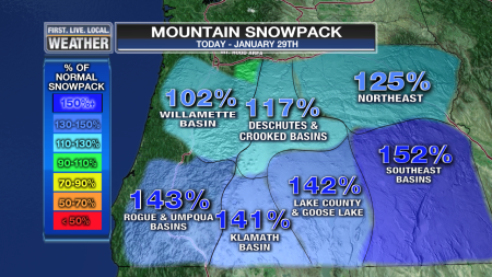
Compare these numbers to one month ago:

MarkSnowpack_Oregon_PlusFacts

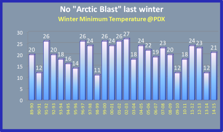
Still MUCH better than the disaster last year!  Note this graphic is from LAST YEAR…

MarkSnowpack_Oregon_PlusFacts

Looking ahead, we’ll see lowering snow levels over the weekend.  Sunday morning I could see it sticking down to around 1,500′ and down around 1,000′ Monday morning.  That said, it looks mainly dry Monday morning.  After that snow levels rise again so whatever we see in the lowlands Sunday and Monday should be “Conversational Snow”.  That means lots of us see snow showers or snow/rain mixed, but it doesn’t affect our daily lives.  But we tell friends about it and Tweet/Facebook it.

Have a great weekend!

Chief Meteorologist Mark Nelsen


ECMWF Monthly Run Maps

January 28, 2016

3pm Thursday…

Time for another run of the ECMWF out to 32 days.  This one says “winter is over” after the middle of next week.  Yes, I know I’m being dramatic but at least I didn’t put it in the headline for click-bait!

One map for each of the next 4 weeks showing average 500mb height among the 51 ensemble members along with departure from average for this time of the year.  The first week is a little misleading because we have a cold trough over us to start and then a ridge (NEXT weekend) so they average out to near normal.  Basically a change is occurring midway through the week.

500za_week1_bg_NA

Beyond that it’s saying we get ridging through much of February.  Remember, it’s just one extended run of one model, although the message is similar to what it was showing 3 days ago.  At first it’s a full-latitude ridging (dry in California too), then it morphs more into ridging up north and wetter south.


Speaking of next week…

With a colder airmass Sunday night and Monday a weak surface low is shown on the WRF-GFS moving down the coastline.  This can be a good setup for snow to very low elevations.  Someone at a business lunch today said they heard it was going to snow Sunday.  Not sure where that came from because we’d be lucky to get sticking snow below 2,000′ on Sunday.  The ECMWF doesn’t show the low and is drier; but it’s something to keep an eye on for Monday.

There is also the possibility of snow/ice in the Gorge the middle of next week IF moisture returns and IF easterly flow sets up.  Not a good possibility for now, but keeping an eye on it.

Chief Meteorologist Mark Nelsen


Have We Seen the Coldest Of Winter?

January 27, 2016

11pm Wednesday…

Whew, a busy day for the news folks.  That means not much focus on the weather despite record highs at Salem and Roseburg.

PLOT_Highs_ORWA

Here in Portland there was just enough easterly flow to keep us “cool” at 54 degrees…two degrees below the record for the date.  Note that the 47 degree low “today” (calendar day) is the warmest low temperature since early January.  We haven’t seen frost in almost 3 weeks here in the city either.  A very mild 2nd half of January for sure after a nice and chilly start!

That brings up the question people often ask me this time of year (when temps start to warm).  “Has the coldest weather of winter passed on by?“.  I think that’s quite possible this year.  First, we’ve dropped to 24 at PDX twice in late November.  Then and again in early January the colder suburbs dropped into the upper teens.  Compare that with the past few years:

MarkColdestNightLows_Yearly

If we only have a low of 24 that’ll be a bit on the warm side, although not too unusual.  Look at the low temperatures over the past 20 years.  The title refers to last winter, although it may end up being correct for this winter too.

MarkWinter_ColdestDay

Take a look at a neat graphic from Climate Matters, showing the average date of the coldest winter temperature

2016ColdestDays_CONUS

We already know our coldest winter temperatures are often in late December, but you can see here it tends to be later in the winter in the Eastern USA, especially in the northern areas.  That’s because widespread mid/late winter snow cover reflects the sunlight well over there.  A wide open path for arctic airmasses to move south over the snow-covered terrain doesn’t hurt either.

The last two big El Ninos featured mild January/February weather so I think it’s UNLIKELY we have anything colder than 24 in the next 5-6 weeks.  Of course we know it’s POSSIBLE this late, but it seems unlikely this year.

Chief Meteorologist Mark Nelsen


The Big Picture: Warm, Cool, Warm Next 16 Days

January 26, 2016

3pm Tuesday…

Time for a look at the general weather pattern.  During the past 30 days the West Coast has slipped into a much more typical El Nino pattern with a bit drier than normal weather north of Oregon and wetter than normal down in northern/central California with most jet stream energy directed to our south.  Sytems have been quite weak (splitting jet stream), but still coming inland with enough frequency to boost our rainfall to average or a bit above in western Oregon.  Cool colors are wetter than normal.  Parts of central California have seen almost double the typical January rain/snow.

anomimage

We haven’t seen much rain in far southern California…they would probably like some more down there.

Temperatures have been a bit cooler than average across large parts of the West.  We started very cool here in Oregon but now are moving above average the last few days of the month.

anomimage (1)

We’ll end up a little above normal, but not like the 3 degree warm anomaly last month.

Looking ahead to the next 2 weeks…

  1. No sign of an arctic blast for the Pacific Northwest on any model.
  2. Rain should be near normal.
  3. There is no obvious “snow pattern” in the lowlands the next 14 days.  Except for one 24 hour period;  snow levels will be quite low from Sunday night through Monday .night.  But it looks like just dry to me.  That’ll be something to keep a close eye on.
  4. Mild temps continue before that time and return about 10 days from now.


Models have been doing very well (forecasting big picture) lately and are in excellent agreement on pattern changes over the next two weeks.  Warm ridging over us now (it rained at the ski resorts today), then a cold trough over/east of us from Sunday through sometime later next week.   Note the ECMWF 500mb height anomaly Sunday; some overdue chilly air.  It’ll feel like January again:

ecmwf_sundayanomaly

This is not a very wet pattern and sure enough the ECMWF is basically dry from Sunday through late next week:

ecmwf_meteogram

The latest GFS (18z) isn’t nearly as dry, but not exactly a soaker either for next week:

gfs_18zmeteogram

The first week of February will be cool though…note those high temperatures drop about 10 degrees from what we’re seeing now.

Then ridging or at least flatter westerly flow returns for the 2nd week of February.  The 500mb height anomaly from ensembles from the ECMWF/GEM/GFS models today for February 10th.  Actually the GEFS is a 5 day average ending on the 10th:

Since I haven’t shown enough maps, here are the 4 weekly ensemble charts from Sunday night’s ECMWF run.  They look “ridgier” in the last two weeks and could be quite warm (fork time).  That said, the actual operational run showed a very chilly airmass over us around Valentine’s Day and beyond with northerly flow.  It showed the ridging farther west.   We’ll see.

Chief Meteorologist Mark Nelsen


Skiing: Best Next Weekend

January 24, 2016

10pm Sunday…

What timing!  It rained part of last week at the ski resorts, then snow showed up just in time for the weekend.  It looked like this at 9am from our camera at the top of Mt. Hood Skibowl

Timelapse2

The same sequence repeats for the last 7 days of the month…warmer and occasionally rainy weather Tuesday-Thursday.  Then much cooler Friday-Sunday.  Yes, looks like another great weekend of skiing ahead

MarkSnow_MtHoodFcst

Here in the lowlands it’s pretty obvious the dry days are going to be Monday and Wednesday.  A surface low could bring a one day return to “December-like” conditions either late Thursday or Friday.  I’ll be keeping an eye on that.

Chief Meteorologist Mark Nelsen


Decent Skiing This Weekend

January 22, 2016

The 2nd half of this week was quite warm, we hit 59 in Portland today and Government Camp was in the 40s the last two days.

PLOT_Highs_ORWA

But good news for skiing, a cooler airmass moves inland Saturday and temperatures cool.  I expect 2-4″, all above Government Camp’s 4000′ elevation.  By night ski time the sticking snow level should finally drop down to around 4,000.

Colder temperatures Sunday mean a pretty good weekend for skiing, especially considering I see another round of warm rains Tuesday-Thursday this coming week.

MarkSkiWeekend_MtHood

There will be another, cooler, period of 3-5 days starting next Saturday.  All models are in agreement with a cool trough moving through the West.  Unfortunately they all show mild westerly flow returning in early February.  Here are the ECMWF ensembles; the top section shows maximum temperatures for each 12 hour period.

KPDX_2016012212_pnx_360

Note the low point around February 1st.  I have noticed in cool patterns these numbers are a little low for PDX.  But mid 40s sound good.  The lower section shows minimums for each 12 hour period.  Looks like frost will return for a few days with the cool spell.  I’m feeling more confident the 24 degree low in November will be our coldest temperature of this winter…

Chief Meteorologist Mark Nelsen


First 70 of the Year

January 21, 2016

6pm Thursday…

I see North Bend hit 70 degrees this afternoon, as far as I’m aware that’s the first 70 of the season.  Many areas along the Coast made it into the 60s and Eugene was close to 60.  I see a good chunk of the Clackamas county foothills (Beavercreek, Colton) were around 60 as well.

MarkFirst70Oregon

In most of the metro area highs made it into the 50s, kept “down” by the typical January low-level inversion and cool easterly wind.

PLOT_Highs_Metro

January has been an interesting month with respect to temperatures.  We were cold and sunny then cold and cloudy/wet during the first 12 days.  Since that time we’ve turned mild and wet with a split flow much of the time; it appears we’ll stay that way through the end of the month.  Sure, a bit cooler Sunday/Monday and again the last day or two.  What is most notable is the lack of strong systems even though we’ve been wetter than normal.  That is due to the very weak ridging or split-flow.   Basically we’re spreading out the storm action along the coast more than we typically would see.  Sacramento has seen double what they would typically see in January.  San Francisco is running above normal as well.

January will end up a warmer than normal month; like December.  That part of El Nino is working out quite well for us…a very mild winter.  There was debate on whether it would be a “drier” or “wetter” El Nino, and now we know it is/was a wet one!  But I think everyone agreed it would be a mild winter.

Looking ahead, here are the 4 weekly ECMWF maps from the 32 day run last night:  You see the wet/mild pattern over the next week, then the cool troughing the end of the month and first few days of February.  Then ridging seems to pop up close to us again for milder weather.  I sure don’t see snow levels below 2,000′ in the next two weeks so the relatively boring weather pattern will continue.

C