Heat Wave Continues One More Day

July 29, 2020

8pm Wednesday…

One week ago I posted that our hottest weather of the year was on tap, evening mentioning a 100 degree temp was possible. It happened, and now we are in the middle of a heat wave across Oregon and the southern part of Washington. We actually do very well (as do models) with heat waves; I can’t think of a heat wave we have “missed” in at least 15 years. They are so easy to forecast compared to wintertime events with inversions, temps near freezing, and mixed precipitation types. PDX hit 93 today and the entire Willamette Valley reached into the mid 90s

A scorching mid-summer heat wave continues in central/eastern Oregon. Expect over 105 along the Columbia River from John Day Dam to the Tri-Cities. Hermiston has gone from 101 > 104 > 106 the past three days

Tomorrow the NWS is forecasting 109 at Hermiston, among the top 5 hottest values there. Just about everyone east of the Cascades, even up around 3,000′, will hit 100 degrees.

Hermiston hit 111 during the June 2015 heat wave so this won’t be an all-time record, but close. Why so hot? A typical summertime hot ridge of high pressure in the upper atmosphere; centered just about over the Grand Canyon region. Hottest air is east of the Cascades = less than 100 degrees for Portland. Plus with the upper-level ridge east of us we don’t get easterly surface wind like we saw Sunday.

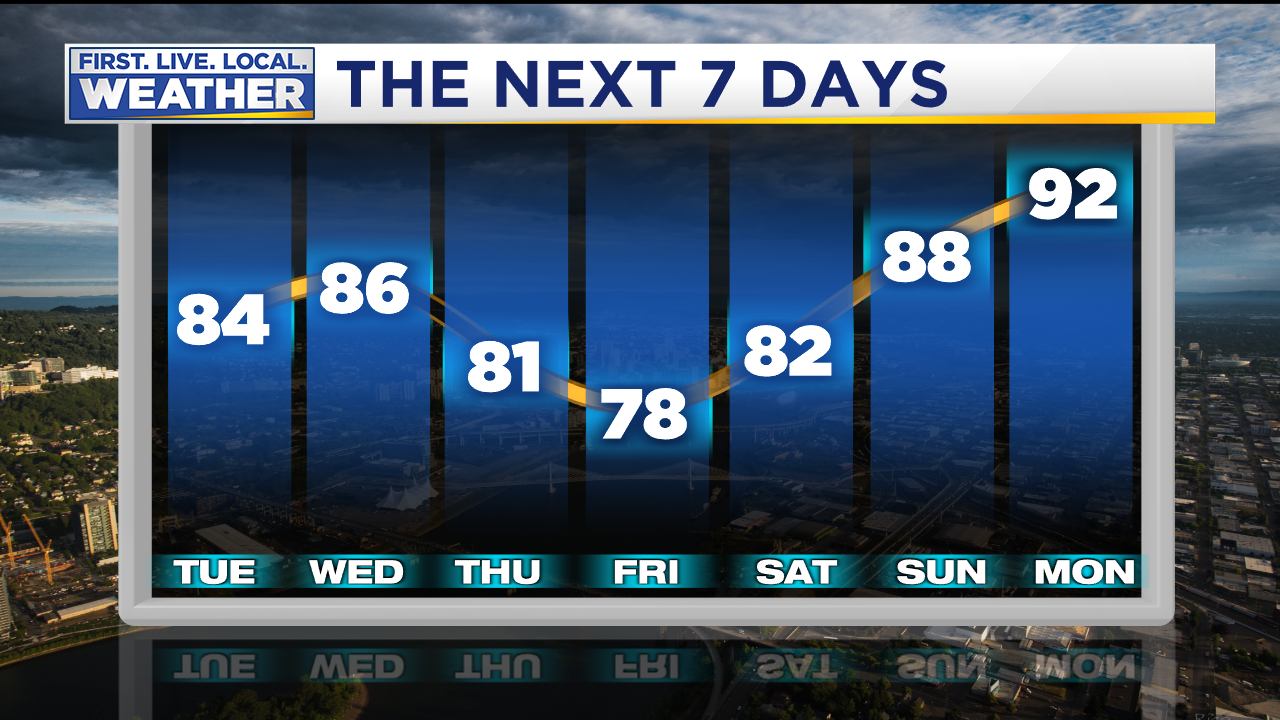
Tired of hot weather? Good news is that marine air will surge inland tomorrow night and cool us back into the 80s. By Saturday the ridge is a bit weaker overhead too, but “heights” are still high enough for a very summery weekend in the Pacific Northwest.

Then an upper-level trough moves by just north of us late Sunday/Monday. That’s a big push of marine air, maybe a day only in the 70s Monday if we get lucky

In general this ridging seems to want to stick around for another 10-14 days. The result should be little/no rain through early August and temperatures near/above average. Check out the ECMWF ensemble forecast for rain. Each line in the top half of the image is one individual ensemble member’s rain forecast. The bottom half shows the average of all ensemble members. Yep, less than .10″ rainfall at Salem in the next two weeks!

How warm? After one more hot day tomorrow in Portland, we cool into the low-mid 80s and then around 80 next Monday/Tuesday. Expect at least some warming the mid-latter part of NEXT week.

To summarize…

TYPICAL WARM/HOT & DRY SUMMER WEATHER CONTINUES UNTIL FURTHER NOTICE

Chief Meteorologist Mark Nelsen


Another Round of Hot Weather Sunday-Tuesday

July 22, 2020

11pm Wednesday…

Today was far more comfortable west of the Cascades with high temperatures only in the low-mid 80s after morning clouds.

Expect more of the same tomorrow and Friday as marine air is in control westside. Nature’s air conditioning will keep us near/below 80 degrees through Saturday. That’s because weak weather systems (upper level troughs) keep moving by to the north in British Columbia. Here’s the view around 18,000′ on Friday from the GEM (Canadian) model showing that “dip” in the upper-level flow:

But see what happens by Sunday? An upper-level ridge pops up directly over the Pacific Northwest

An upper-level ridge this warm (590 dm heights) sitting directly overhead is heatwave material in July and August. So far this season we haven’t seen a hot ridge move right over the top of us. Models are forecasting +22 to +24 degree (Celsius) temperatures at 850mb (5,000′) over us Sunday and Monday afternoon. That’s also heatwave material. Third, a couple models produce easterly flow down off the Cascades Sunday, and to a lesser extent, Monday. The surface pressure map for Sunday shows what we call a “thermal trough” west of the Cascades.

If that develops, we could hit 100 degrees in this pattern. We’ll go slightly cooler and aim for 98 both days. Beyond that time, the ridging weakens and temps go back closer to normal by the middle of next week. Here’s our current Portland forecast:

That’s it for this evening…I’ve got a weekend plus a couple days of vacation coming so no blog post until at least next Tuesday. Enjoy the comfortable weather ahead of the hot weather early next week!

Chief Meteorologist Mark Nelsen


A Hot Monday; Cooler Temps Ahead Rest of This Week

July 20, 2020

10pm Monday…

It finally happened, after a very cool start to July we’ve seen two consecutive hot days. We hit 90 in Portland yesterday and 93 today

This tied for the warmest/hottest temp so far this summer. At this point we’ve seen 4 days at/above 90 in Portland this summer. Keep in mind all the other numbers below refer to the entire summer. A typical summer will see around 13 days at/above 90 in Portland. Some crazy hot summers in there! (2014, 2015, 2017, 2018). Last year and this have been so much more reasonable.

June was wet (although not cool), and the first 10 days of July were very cool. That prompted the annual worry-fest about whether “this could be the year without a summer”. But the past 10 days have brought our temperature for the month close to normal. This definitely isn’t and will not be the year without a summer

Something really sticks out on this map…do you see it?

It’s Newport. Check out the HIGH of 52 today; similar to a January day out there! And it’s much cooler than other coastal stations in the 60s to lower 70s. What’s going on? It’s the very chilly Pacific Ocean sea surface close to the coastline. The latest sea surface temps here, along with some buoy water temps

Notice most of the Pacific offshore is in the 60s, or at least upper 50s and 60s. But a narrow ribbon of 48-55 degree water is right along the beaches. This is called “upwelling”. Gusty northerly and northwest wind blowing down the coastline causes a slight “rightward” movement in surface water (farther offshore). That allows cold subsurface water to replace it; I remember learning about it during a 5th grade school visit to the beach. I sure remember that field trip from Monitor Grade School. We all got into BIG trouble for wading into the ocean and had to write an essay about how bad we were…but I digress a bit. Scary to think about as a parent now!

Diagram credit: NOAA

You can read more about upwelling here and how critical it is for our fisheries along the PACNW coastline.

The downside is of strong upwelling? Colder than normal water temperature right long the coastline = chilly onshore wind. When we turn hot and the marine layer is thin, temperatures will vary dramatically depending on location. For example that Newport high of 52 is at the airport right at South Beach.

Looking at those other high temps, I would say the high at Newport was really more like 60 degrees. You get the idea…right on beaches = cold, slightly inland = just a little cool.

So what’s ahead? More of the same. We haven’t seen significant rain in a month and no model shows showers in the next 10 days either! Check out the ECMWF ensemble forecast for the next two weeks; this is 24 hour precipitation. Only 5 of the 51 ensemble members produce more than .10″ rain in Portland through Monday August 3rd

A weak push of marine air tonight should keep us below 90 tomorrow, then a major push tomorrow evening means highs around 80 for Wednesday-Friday. Models then develop upper-level ridging (warming) overhead Saturday through next Monday/Tuesday. Expect warming again. This is the typical seesaw west of the Cascades in midsummer. Very warm, cooling, then warm again

Looking at this you can pick out the days that are best for certain activities. Mow the lawn on cooler Thursday, hit the lake or your pool tomorrow and this weekend. Regardless, enjoy our fantastic Pacific Northwest summer weather free of high humidity and extreme heat!

Chief Meteorologist Mark Nelsen


Spots of Drizzle Friday Morning, But a Warm Summer Weekend Ahead

July 16, 2020

8pm Thursday…

We’ve settled into a warm summer weather pattern as models were predicting. The past 8 days Portland made it at least into the upper 70s, and now four consecutive days at/above 80 degrees…pool weather!

Anywhere south and east of Portland it was warmer today; Eugene hit 90 and most of central/eastern Oregon was around 90 or higher.

Portland hasn’t seen significant rain in over three weeks either…grasses are drying out finally.

A relatively strong marine push is underway this evening; a gusty northwest wind is blowing up the Columbia River bringing cooler marine air inland. There are two weak disturbances passing by in the upper atmosphere just north of us are helping that along. The result should be a cloudy start Friday and a cooler day. 84 in Portland today; more likely 76-78 tomorrow. You can see the low clouds forecast by the IBM’s GRAF model at 7am tomorrow

The marine layer should be at least 5,000′ thick tomorrow morning, and that passing upper-level disturbance will supply some lifting. Expect spots of drizzle or even a very brief light shower between 5-10am. Don’t leave anything outside tonight that won’t survive getting wet! But we’re talking REALLY light…a few drips

Beyond tomorrow, high pressure noses back into the Pacific Northwest. By Sunday evening, a hot upper-level ridge is just offshore with warm air extending back over the West Coast

But then by Wednesday the ridge offshore has “flattened” a bit, allowing cooler marine air to come inland once again. But upper-level heights are still above average (the warm colors), so there’s no return to cool and showery in the cards for next week.

The orientation and position of that upper-level ridge offshore brings up two thoughts:

  1. No offshore wind flow at the surface Saturday through the middle of next week = no extreme heat
  2. Upper-level temperatures don’t get crazy warm. Looks like the 850mb temps don’t go above 20 degrees. That’s warm enough for lower 90s with onshore flow in July, but not much warmer. I’d be surprised if PDX gets above 95 early next week.

Here’s our forecast for the next 7 days…not a heat wave, but toasty Sunday through Tuesday

I see good pool and “water play” weather this weekend and early next week, but again, we won’t be roasting in a big heat wave. Enjoy your weekend!

Chief Meteorologist Mark Nelsen


Summer Weather Heating Up

July 13, 2020

9:30pm Monday…

I’ve seen quite a bit of complaining about Summer 2020 so far. A wet June was followed by a cool July start. In fact this month is running 2.5 degrees below average; the coolest start to summer in 8 years. Summer is defined by June 1st through July 12th in this case. We have seen 5 days of very pleasant weather with temperatures near normal though.

Today’s 80 degree high under mainly sunny skies was about as “normal” as it gets for July 13th.

A clear shift into the dry season arrived right on schedule though. We have seen less than .10″ rain in the past three weeks! And I see very little in the next 1-2 weeks. Check out the very dry ensemble rain forecast from the ECMWF model. It shows 51 different ensemble members as horizontal lines through the next two weeks. Only TWO of those members produce any significant rain over Salem (Portland is similar) and it’s brief. Most likely attempting to bring thunder up from the south.

So what’s ahead? A quick summary:

The next two weeks will feature the weather some of us wait for. Expect reliably dry and warm weather with near to above normal temps…plus abundant sunshine. This is it folks!

What has changed? All models are, in general, keeping upper-level heights quite high over us the next two weeks. A hot ridge of high pressure doesn’t seem to want to sit directly over us for a major heat wave, but heights remain high. Here’s the GFS ensemble 500 millibar chart for tomorrow

The cool trough that brought us sprinkles/showers Sunday morning is over the Rockies and northern Plains. A warm upper-level ridge is sitting just to our west over the Eastern Pacific. It’s not right over the West Coast, but heights are above average for mid July (the warm colors) over us. Then look at Thursday night; a fast moving upper-level wave rides over the ridge. In summer this means a strong marine push of cooler ocean air, but typically no rain.

By this Sunday (the 19th) the ridge is rebounding and moving closer again. Notice heights are up to 588dm. That means the 500 millibar pressure level is way up over 19,000′; a warm/hot airmass is pushing overhead with the core of the warm air offshore.

By Tuesday the ridge offshore is a bit weaker and farther away. But the main thing to see here is that upper-level heights are above average all across the region. This is a warm weather pattern through these 10 days, but not excessively hot.

With that ridge nudging a bit closer to us next Sunday-Tuesday, we may turn hot for a brief period. It’s not real tough to see a few 90-95 degree days in late July in Portland! This is what we’re thinking right now for Portland:

Enjoy the dry and warm summer weather!

Chief Meteorologist Mark Nelsen


Where is Summer? A Look Ahead After Coolest July Start in 10 Years

July 7, 2020

8:30pm Tuesday…

It has begun…complaints about cool summer weather. I often get complaints this time of year, some people expecting that we should have Sacramento style heat in Portland. To be fair, the past two days have been especially cloudy and cool. Today was the 2nd day in Portland without seeing a 70 degree temperature; our typical high this time of year is 78-79 degrees!

We’re now approaching two weeks of below average temps.

The average high temperature for this first week of July is the coldest since 2000! My little butternut squash and cucumber plants are struggling…just a few inches high. Too little sun and most days only in the 60s up in the hills. At least we haven’t seen much rain the past 2+ weeks; it’s very clear our dry season has arrived.

So, the big question…

IS THIS IT?

WHAT WE ARE SEEING NOW…IS THIS OUR “SUMMER” THIS YEAR?

The short answer; it’s unlikely this same cool weather pattern continues the next 9 weeks to Labor Day. But there is no sign of hot weather in the next 7-10 days either.

First, we are overdue for an average or cool summer west of the Cascades. I’m not saying that’s about to happen, but the past six years have featured an unprecedented string of warm to hot summers in the Portland metro area. 2016 wasn’t crazy warm and neither was last year. In fact much of the warmth last year was due to excessively warm nights; a consequence of warmer than normal ocean water offshore.

My point in bringing this up is that, at some point, we should expect to get a cool summer.

The weather pattern the past two weeks has featured a setup like this in the upper-atmosphere; weak “troughing” or a dip in the westerly flow over the Pacific Northwest. High pressure (and warmer air) has been suppressed to the south and east regularly. Notice most of the country is very warm to hot! We are all alone in the cool weather out here

A warm/hot July weather setup looks more like this; the westerly flow pushed farther north into Canada. That takes much of the cloud cover and showers north as well = sunnier and warmer weather west of the Cascades

Looking ahead, that upper-level trough backs off a bit the rest of this week. The result is more sunshine and warmer days. By Saturday that hot upper-level ridge is much closer to us. At this point it appears this should finally be a setup for a sunny Saturday and temperatures in the 80s.

But by Monday another system is passing by to the north, once again bringing a surge of cool marine air inland Sunday and maybe even a shower. A continuing issue the past couple of weeks is models only catching onto these cold troughs about a week ahead of time. A week ago it appeared we’d be heading into a very warm summer pattern this coming weekend. Instead that is being delayed once again by this system Sunday/Monday

Looking farther ahead, we should warm again a week from now as high pressure builds just offshore. This is the GFS model for next Wednesday the 15th

The morning ECMWF model’s forecast for high temps in Portland shows this trend as well.

Warming through this Saturday, then cooler, then warming again a week from now. You can add about 5 degrees to most of these to get a Portland high temperature. In general this is a bit warmer than what we’ve seen the past two weeks. It would imply the next 10 days will be near average for mid-July.

No model shows a wet weather pattern ahead, just a few drips here and there. ECMWF says less than .20″ in the Willamette Valley through the next two weeks. As mentioned earlier, the dry season is here:

It’s summer and vacation time, so I’ll be off until Sunday. Enjoy the warmer late-week temps!

Chief Meteorologist Mark Nelsen