Siberian Smoke Likely Back For Bright Orange Sunrises & Sunsets

April 29, 2015

10pm Wednesday…

Did you see the sunset tonight? Some areas were clear enough that we could see a very orange sun as it sank to the horizon. It appears another “cloud” of smoke/haze is back…most likely from fires in Siberia. Here’s the 6pm smoke discussion from NESDIS:

…A large area of unknown aerosols is moving in from the Pacific Ocean over the US Pacific Northwest and southwestern Canada. Models suggest this area may contain blowing dust from Asia as well as smoke from Siberian fires…

And a blog from NASA says the smoke is moving across the Pacific on the east-flowing jet stream.  Here’s a quick screen capture:

Capture

So enjoy the bright sunsets we’ll probably see the next few days.

Chief Meteorologist Mark Nelsen


82 Degrees Monday: Warmest This Year

April 27, 2015

Quite an April “scorcher” out there today:

PLOT_Highs_Metro

The 82 degree high at PDX was above our forecast of 80 degrees.  Not quite a record (86 in 1987), but 18 degrees above average!  The Salem sounding at 5pm showed an 850mb temp of +14.6 degrees.  In non-meteorological jargon: The temperature around 5,000′ elevation over Salem was about 58 degrees.  It could have been even warmer;  my chart for April shows easterly flow, solid sunshine, and a +14 has seen a Portland high temp as high as 85!  Models had shown +12 or +13, thus the forecast of 80.

Maybe more amazing is the jump from yesterday.  The high temp jumped 21 degrees in one day, which I haven’t seen happen in the spring.  Of course we’ve seen it drop 20 degrees in one day (tomorrow?) due to a major marine push and/or a cold front passage.

The easterly pressure gradient has increased this afternoon and evening, giving a peak gust over 50 mph at Crown Point and 40 mph at Corbett.  It’ll back off dramatically by sunrise as low marine clouds flood into the valley.

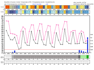
We’ve got a weak cold front moving inland tomorrow so expect some showers but not a big soaking.  In fact I don’t see any other decent chance for rain in the next 7-8 days.  This might be a year in which we start watering in May unless a trough materializes the middle of next week with a nice soaking (.50″ or more).  Both the 18z GFS meteogram and 12z ECMWF meteogram showed less than 1/2″ in the next 7-10 days.

ecm_meteo

gfs_meteo

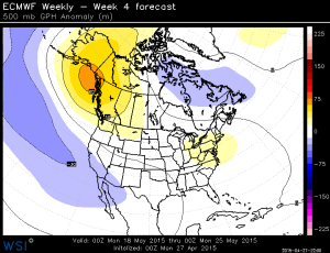
It does looks like a very mild and “settled” weather pattern over the next week.  By that I mean that after tomorrow’s disturbance moves past we see the action lift north.  This is typically what we see later in May and June.  So temperatures warm to above average over the next week.  This may be a re-emergence of the ridging we’ve seen so often over the past year or so.  Take a look at last night’s ECMWF monthly run.  One map representing the average height anomalies for each week.

500za_week1_bg_NA

500za_week2_bg_NA

500za_week3_bg_NA

500za_week4_bg_NA

Same sort of splitty pattern we’ve seen recently with lower than normal heights to our south and higher than normal to our north and northwest.

Chief Meteorologist Mark Nelsen


Will Detroit Lake and other Willamette Reservoirs Fill? Maybe Not, But Don’t Panic

April 23, 2015

Have you driven by one of the Willamette Reservoirs lately and wondered if they will actually fill for summer recreation?  Good question!

Now let me point out that it’s perfectly normal to drive by Detroit Lake, Green Peter, Lookout Point, Cougar, & Hills Creek reservoirs in winter time and see them extremely low.  That’s all the extra space left each fall for rainy-season flood events.  The storage built into these reservoirs keeps us from seeing regular flood events in the Willamette River system (including Eugene, Salem, & Portland!) each winter.

Here’s a graph with a bunch of lines…it’s for Detroit Lake (east of Salem):

DetroitLakeYearlyCurve

First, ignore the entire bottom half of the chart and focus instead on the thick red line on the upper part.  That’s the “control curve” showing, in a perfect world, where officials want the level of the lake to be during each part of a normal year.  Notice the lake is normally kept “full” from around May 1st to September 1st, then the level is dropped to the winter minimum by December 1st each year.  It is kept there (if possible) through February 1st, then filling begins.  That gives the Corp 3 months to “empty” reservoirs in the fall and 3 months to fill them in the late winter and spring.  In the case of Detroit Lake the lake level varies about 113 ft. from “empty” to “full”.

Now look at the blue line…that’s the actual level over the past 12 months.  Notice last summer the lake dropped a bit lower than preferred in the 2nd half of summer and then followed the “curve” more or less through the fall and early winter.  As a meteorologist it’s interesting to note the wintertime spikes when heavy rainfall suddenly fills the reservoir.  In late December the level jumped about 40′ in a very short period of time!  February 1996 must have been crazy!  On that blue line you can also see that right after a heavy precipitation event lots of water is poured downriver to quickly bring the level back down to where it should be in winter.

Two things I’ve noticed in the past few months:  They started allowing it to fill earlier than normal this year (mid/late January) since it was obvious ridging was going to stick around that point with its dry weather.  Then you can see how the filling is going much more slowly this year.  A week from now (May 1st) the lake would typically be “full”.  Not this year!  Looks like it is running about 45′ below the curve right now, which means as you drive by it’s only as full as it would typically be in late February or early March.

So will it fill?  Most likely NO.  But that doesn’t mean no boating! Here’s a forecast from the Army Corps of Engineers from about a week ago:

DetroitLake_Fcst

The purple line on the left side is the past and then future forecasts (and levels right now) begin at the dotted line.  The blue line is the most likely scenario, assuming normal precipitation/conditions over the next month or two.  The red line is the line in which there’s only a 5% chance it’ll get above that.  Looks like officials think it’s most likely the lake will top out around 1450’…about 13-14′ below full pool.  What does that mean for boating?

Take a look at (ONE MORE) chart for the past 7 days:

Detroit_BoatRamps

This one shows all the boat ramp elevations.  There is one that’s available all year long…the low water ramp.  But the current level is still at least 20-55 feet below all the other ramps.  The good news is that most of those ramps should be available this summer according to the forecast levels up above.  You’re just going to have to wait a bit longer to get on the water this year!

I didn’t look into any forecast for other reservoirs…although you can find all the info on the Army Corps of Engineers Willamette Basin Web Page.  You can see all the reservoirs are well below normal in this graphic:

WillametteReservoirs

So don’t panic if you have party plans on “the lake”…there WILL be some water to play on!

Chief Meteorologist Mark Nelsen


Air Force Dumping USA models

April 21, 2015

Capture

I just read some interesting articles and blog posts about a major change in the US Air Force.  They are dumping their WRF model (and support) and instead going with a UK model!

Here’s an article from The Capital Weather Gang.

And a blog post from Cliff Mass up at the UW.

I don’t have any great thoughts about it because I just now read the articles myself.  Seems like a bad move in general though.

Today was crazy wasn’t it?  We dropped from 81 yesterday to 62 today.

MarkTemp_Last12Days

At one point this evening (around 5pm) we were running about 25 degrees below yesterday at the same time!

That’s all, not much weather happening except a huge cooldown in progress.  Snow flurries may stick down to around 3,000′ tomorrow morning!

Chief Meteorologist Mark Nelsen


First 80 Degree Day!

April 20, 2015

6pm Monday…

We hit 81 in Portland today

PLOT_Highs_Metro

The first of the season.  Almost all of us in the metro area hit 80.  Quite a warmup over the past week!

MarkTemp_Last12Days

This year we hit 80 a bit earlier than average…which has been around May 10th

MarkHeatwaveStudio_First80DegDays

Remember 2010 & 2011?  Some were worried endless slugs, rotted veggies, and April-June downpours were the new normal.  Apparently not.  As of today, we’ve seen 5 days at/above 70 degrees, the most real warm days in April since 2009.

MarkHeatwaveStudio_70DegreeTemps_April

By the way, we could see the start of the Government Camp condo fire this afternoon from the Mt. Hood Adventure Park camera at Skibowl East.  Note the left side of the timelapse:

Chief Meteorologist Mark Nelsen


Another Smoky/Dusty Sunrise: Could Keep Us Below 80 Degrees

April 20, 2015

7:30am Monday…

You’ve probably noticed the haze in the air the past 48 hours, especially Sunday.

OMPS_AI_over_VIIRS_RGB_na_2015_04_19

It’s smoke from fires in Siberia, with probably some dust thrown in too.  Here’s a detailed description from NESDIS (your tax dollars at work!):

A relatively expansive plume of smoke is capture in morning visible satellite imagery extending from southern Saskatchewan across central Montana, northern two-thirds of Idaho, Washington, Oregon, and northern California. This area of smoke (with a low probability of dust/sand mixed in) has been traced back to numerous large wildfires burning across Siberia. These fires produced pyrocumulus clouds that enabled the smoke to rise quickly and become entrained in the atmospheric jet stream. The first plume of smoke that has been since transported across the northern Pacific and is now located over the Pacific Northwest and southwestern to south-central Canada. Additional large detached smoke plumes were seen yesterday beginning to follow the same trajectory.

That was yesterday, but this morning the satellite image shows thick smoke over us once again.

Beijing also had their worst sandstorm in a decade from the same system that brought the strong winds across the border in Siberia:  http://ozoneaq.gsfc.nasa.gov/omps/blog/2015/04/worst-sandstorm-hit-beijing-over-decade

Cliff Mass blogged about this yesterday too:  http://www.cliffmass.blogspot.com/2015/04/siberian-smoke-reaches-northwest.html

For us, this means we have the hazy skies and slightly reduced heating from the sun.  A great example is from USFS RAWS sites.  This one from Mt. Wilson SE of Timothy Lake:  http://www.wrh.noaa.gov/mesowest/getobext.php?wfo=&sid=WSFO3&num=168&raw=0&dbn=m&banner=off

Look at the SOLAR RADIATION column and you’ll see the values each hour in Watts per Square Meter (W/m^2).  Notice on Friday and Saturday it is around 900-920 max, but then only around 830 yesterday, so maybe a 10% decrease in solar radiation reaching the ground.  That could be enough to chop a couple of degrees off the high and that COULD keep us below 80 again today.  Offshore flow is a bit weaker than I expected too…less than 2 millibars through the Gorge.

Nevertheless, a GREAT day again today with highs near 80…enjoy!

Chief Meteorologist Mark Nelsen


Nice View of Bird Migration Tonight

April 18, 2015

10pm Saturday…

Sometimes I have coworkers laugh at me when I mention we can see migrating birds on radar.  We can’t see specific birds (1 mallard, 2 loons, 3 Canada Geese etc…) but objects that reflect energy back to the radar.  This is what the radar loop looks like

Here is the three-hour radar loop from the Portland radar (located SW of Scappoose) ending at 10pm:

codnexlab.NEXRAD.RTX.N0Q.20150419.510.024ani

Notice under clear skies we suddenly see the radar screen fill up after sunset.  Most birds prefer to migrate in the nighttime hours when wind speed and turbulence are both (often) weaker.

This evening’s VAD wind profile from the Portland radar makes it pretty obvious what’s going on.  Keep in mind that we have north/northeast wind 10-20 mph over us this evening from just above the surface to 10,000′.  That’s from the evening sounding; the balloon that’s launched twice a day over Salem.

codnexlab.NEXRAD.RTX.NVW.20150419.503.024ani

Notice the wind is from the north before sunset, then right after the “wind” switches to the south and the radar echoes gradually rise in elevation.  That’s birds taking off and working their way up to a higher elevation.  Poor guys are battling a 10-20 mph headwind tonight!

I’ve posted about this phenomenon in the past and you can find more info in a previous post here.

Chief Meteorologist Mark Nelsen