Record High Pressure Today

December 30, 2014

It’s not one of the sexier meteorological parameters, but some people ARE into pressure.  Capture    If you have an old-style barometer, you may have noticed it’s very high today.  In fact it’s the highest we’ve ever seen in December here in Portland and it’s never been higher at Astoria.  Since the NWS put that image out on their FB/Twitter page, the pressure has risen to 30.80″ at PDX.  The meteorological world (and most of the rest of the regular world) uses millibars though.  At 10am it’s 1043.4 mb at PDX and still rising.  You can see the monthly/yearly records for PDX:  Capture

So why aren’t we seeing a damaging wind event?  Extreme high or low pressure doesn’t have a whole lot to do with wind speed.  That’s because wind is produced by the DIFFERENCE in pressure from one spot to another.  Air moves from high to low pressure so if all of the Pacific Northwest is seeing high pressure, the differences across the terrain aren’t as high as a strong high pressure to the east and low pressure to the west (to produce strong east wind for example).  This time around as the strong arctic high pressure moved south out of Canada, it pretty much descended right down over the Pacific Northwest instead of sliding down mainly east of the Cascades.  The pressure gradient from The Dalles to Portland is only around 6 millibars this morning…weaker than we would see in just an average east wind episode that no news media would be interested in.  In fact that gradient is probably typical for about 25% of the days from late November through February here.

High temps today will end up in the mid 30s, then with a calming wind (away from the Gorge) tonight we should see widespread teens in outlying areas and near 20 in the urban areas away from the wind.  Tonight and tomorrow MIGHT be our coldest nights of the winter…we’ll see.

Chief Meteorologist Mark Nelsen


Quick Late Evening Post

December 29, 2014

Cold air mass definitely not as cold as models were showing in the past 24-48 hours.  So I raised 7 Day forecast numbers again…to 35/37/38 degree highs the next 3 days.  That might be too low.  I could see a 37 degree high at PDX tomorrow.

Wind isn’t too wild this evening, as models showed.  They have nailed that part of the forecast well.  I see PDX just peaked at 41 mph but just about all other locations are much weaker.  I expect most gusts will stay below 35 mph.  PLOT_Wind_Metro  Interesting to note that PDX is stronger than Corbett AND Vista House at this hour!  That’s very rare.  I’ve been watching the snow blow around on our Skibowl Camera this evening…Brrr!  Check out the  temps:  PLOT_Temps_MtHood_CamOnly

Because of the cold temps and wind, the NWS has a Wind Chill Warning out for the higher parts of the Cascades, this includes Tuesday so be careful and cover all your exposed skin if you’re headed up around 5,000′ or so on the open slopes.

MarkWarnings_WindchillCascadesText

Other than the cold and breezy wind, some great sunshine now looking likely through Friday.  Beyond that ridging seems to stick around off/on through the middle of next week.

Chief Meteorologist Mark Nelsen


ECMWF Monthly Run

December 29, 2014

Twice a week the ECMWF model is run out to 32 days and sometimes we can glean some basic info about the very general weather patterns ahead.  And sometimes we can’t…

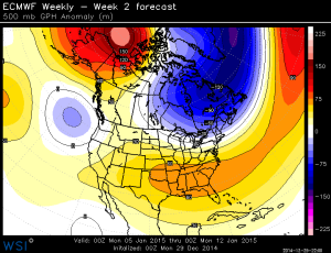
Here are the four weekly averages of 500mb heights, with the anomaly in color.  Blue is lower than average and red is above average.

It’s very good the Cascades had a great dumping of snow because the pattern continues to look somewhat pathetic through January as ridging returns.

Week 1 & 2:

500za_week1_bg_NA

500za_week2_bg_NA

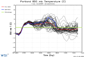
You can see ridging through early next week and then some cooler troughs offshore.  That should give us at least some sort of weather action later next week.  It’s supported by this morning’s ECMWF time series showing temps dropping (in the mountains) later next week:

tseries_850t_000-360_Portland

Week 3 & 4:

500za_week3_bg_NA

500za_week4_bg_NA

That annoying ridging returns overhead and also to the north.  The “El Nino” pattern of storms into California doesn’t show up like it did a week or two ago…that’s interesting.   I don’t have any other thoughts than that.  If these maps are correct, January could be a slow weather month.  We’ll see.

Chief Meteorologist Mark Nelsen


Cold Air Arrives Monday

December 28, 2014

Just 3 days!  In the entire month of December we’ve only seen 3 days with temperatures below normal…all at the beginning of the month.  Since that time it has been very mild.  In fact no freezing here in Portland for over 3 weeks!

MarkTemp_Last12Days_LowsPDX

Tonight we’ll stay mild with temps above freezing and just a few scattered (rain) showers.  Then cold air starts pouring into the Pacific Northwest as skies clear out tomorrow.  I haven’t been expecting any snow below about 1,500′ west of the Cascades because we dry out at the same time the cold air arrives.  That doesn’t mean you couldn’t see snowflakes mixed in with early morning showers, but that’s unlikely too.

The intensity of the cold air looks about the same as mentioned in the previous post.  This is not a “mega” blast of either east wind or cold air that we COULD see this time of the year.  High temperatures in the low-mid 30s under sunny skies are sure chilly, but nothing like 20s!  As for east wind, just the usual gusty easterlies tomorrow and Tuesday, then mainly calm Wednesday/Thursday.  Models only suggest 4-6 millibars easterly gradient through the Gorge, much tamer than the Veterans Day east wind event.  In fact check out the current WRF-GFS cross section:  kpdx.th

vs. the November version…that was a wild forecast and it verified!  kpdx-th1

With calming wind and a cold/dry airmass, we could see the coldest temperatures so far this season either Wednesday or Thursday morning.  23 is the coldest temperature we’ve seen so far in Portland.

Beyond that, models have gone back to a ridging/split flow setup along the West Coast again for next weekend and beyond.  So it’s especially good that we’ve seen some great snow totals this weekend in the Cascades.  What an improvement in just 7-8 days!

MarkSnow_MtHoodTotals2

MarkSnow_MtHoodTotals3

Chief Meteorologist Mark Nelsen


Get Ready For The Coldest Week So Far!

December 26, 2014

It has been very mild December; in fact as of this evening it’s the 2nd warmest December on record at PDX!  But the last 3 days of the month are going to be totally different.  That’s Monday-Wednesday of next week.  Remember the yo-yo temperatures in November?  We saw rapid swings from warm to record cold to warm, and then back to cold at the end of the month.  We’re going to see that happen starting Monday again.

First, let’s get this weekend out-of-the-way.  A cool and wet system is dropping in overnight from the northwest.  This has a beautiful west/northwest flow behind it to pound the Cascades with what could be their best snow so far this season.   We really need it.  MarkSnow_MtHood_Totals  Although some snow has fallen this week and allowed Meadows/Timberline to open at least half their runs, we’re still way behind.  RPM_72_SNOW_00z  Our RPM forecast and WRF-GFS are about the same…showing a solid 12-18″ with possibly up to 2 feet in spots by the time we dry out Monday  Here in the lowlands that means mainly wet with a breezy south/southwest wind both days.

What’s changing Monday?  A strong ridge of high pressure magnifies quickly later Sunday-Monday over Alaska, sending a couple of upper-level disturbances plunging south along the West Coast.  The carve out a sharp upper-level trough over us which eventually ends up in Southern California later Tuesday/Wednesday. gfs_500mb_4pmMonday That is the view at 500mb (~18,000′) Monday evening.  What happens down below is even more interesting.  A HUGE surface high pressure area drops south through Western Canada and into western half of the USA.  Take a look at that monster Monday evening at 10pm:  gfs_1060mb_Mon10pm

It’s covering about a third of the country already with a central pressure right around 1060 millibars…expect your home barometer to skyrocket early in the upcoming week!  Of course cold high pressure to the north and east means gusty northeast wind for ALL OF US (not just in the Gorge) later Monday-Wednesday…probably not as strong as the damaging northeast wind in mid-November, but it’ll still turn windy and cold starting late Monday.

There is a slight chance that as the cold air starts arriving from the east Monday we’ll still have some showers around that could be mainly snow.  But almost always in this situation the cold air slowly trickles in (at first) while skies clear…as a result don’t get your hopes up for any sort of snow Monday.

How cold is it going to get?  One clue is in the 850 mb temps.  Models have been pretty consistent showing -8 to -10 over the northern Willamette Valley.  Seems that with sunshine and easterly well-mixed wind Tuesday we would see high temps around 35-40.  But, check out how cold it is up against the east slopes of the Cascades:  gfs_950_10pmMon

That -15 to -17 celsius at 5,000′ means the ski areas will be in the upper single digits or low teens at best late Monday through Tuesday…Brrrr!  That cold air will be funneled over the Cascades and through the Gorge, cooling us even further.  As a result I think we’ll only be around freezing or just a few degrees above on Tuesday, Wednesday, and New Year’s Day.  And in this pattern there is no obvious warming coming from the west or south, so the airmass will only slowly modify.

I’d tell you to wrap your pipes and sensitive plants, but it was cold twice in November so I assume you already have done that.

Is this going to be a one-shot deal?  Not sure yet.  The 12z ECMWF said YES, any cold air about 9-10 days from now will be diverted to the east or stay up north.  tseries_850t_000-360_Portland  The 12z GFS wasn’t so sure…you can see several ensemble members showing another cold shot.

tseries_850t_000-384_Portland

We’ll have to wait and see.  But for now the screaming message is that our coldest weather so far this cold season is on the way for Tuesday-Thursday.   2014 is going to go out cold!

I’ll probably post again Sunday evening since I’m working again.  But don’t worry about me, I already spent 1/2 hour this evening figuring out which days next summer I’ll take off to make up for it…

Chief Meteorologist Mark Nelsen


A Christmas Miracle In Cascades: Lots of Snow On The Way

December 22, 2014

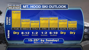
What a change a few days can make.  As mentioned in the previous posting the snow level was slow to rise Saturday, then quicker to lower than expected Sunday.  Add a few more inches last night and suddenly at the 5,000′ elevation we’ve got 18″ or so on the ground.  We’ve been expecting a cold front to move through the Cascades Wednesday and now it appears it’ll be an “ana” front.  That means just about all the precipitation is BEHIND the cold front…excellent new for maximum snow accumulation in the Cascades.  We could see 8-12″ all the way down to Government Camp and below just in time for Christmas Eve!

Beyond that, another wet system drops through on Saturday with a good 4-6″ additional.  Add a few inches in-between on Thursday and Friday and it’s quite possible 15-25″ falls in the next 5 days

MarkSnow_MtHoodFcst_2013

This may even be enough to allow Skibowl to start some operations.  For sure it means the 2nd half of Christmas Break we’ll see far better conditions with a bunch of runs/lifts open at Timberline and Meadows.

Down here in the valleys there isn’t a whole lot to talk about over the next week, although it turns real chilly Sunday and Monday with the ECMWF showing thicknesses down below 525dm.  That means high temps close to 40 and lows into the 20s if skies clear out.  It’s going to feel like winter for the last few days of the month; we haven’t seen that since around the 2nd.

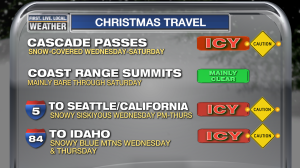
Of course this means snow will return to many roads in the Pacific Northwest starting Christmas Eve too:

MarkRoadConditions_I84_5_Passes

Drive carefully the rest of the week if you’re headed into the high elevations.  I’ll be off the next few days, so probably no blog posting until Friday when I work again.

Merry Christmas!

Chief Meteorologist Mark Nelsen


Whew! Major Flooding Avoided & Lower Snow Level

December 21, 2014

Some good news all around this Sunday morning:

1. It appears no river in our FOX12 viewing area has or will have major flooding

2. Coastal rivers have already crested and are dropping since the rain has tapered off our there

3. Snow levels have already dropped back to around 5,000′ this morning, saving some of the snow in the higher parts of Timberline & Meadows!

By the way, Portland tied a record high temperature before midnight of 59 degrees…that was weird to step outside late in the evening as the rain stopped and feel totally comfortable on December 20th!

As expected, the main rain band shifted south late yesterday evening and we haven’t seen rain at PDX since midnight.  Our RPM model did really well showing less than 2″ in most north Willamette Valley locations.  You can find the latest totals from the NWS here.  It’s still raining in the mountains and those totals have been amazing too.  Lots of 5-8″ totals in both the Coast and Cascade ranges.  Close enough since our models were showing widespread 5″+ and some spots to 10″.  That’s as of Friday evening.

River model forecasts and actual observations are lower now, so no rivers are forecast to go into the MODERATE or MAJOR FLOODING category.  In fact the Coast Range rivers have mainly crested and are falling.  That’s typical for them…they drain quickly.  Note the Wilson River:

tlmo3_hg

The flood warning has been dropped for the Santiam and North Santiam Rivers, and the forecast crest for both the Sandy and Clackamas has been lowered quite a bit.  Here’s the Sandy as of 8:30am.  It’ll be interesting to see if at that location (near Dodge Park), the river is actually cresting right now much lower than forecast.  It looks like that could be the case:

sndo3_hg

and the Clackamas at Estacada, hitting flood stage right now.  Note the forecast crest is about 4 feet LOWER than what appeared to be possible when I left work Friday evening…good news:

esto3_hg

and Clackamas at Oregon City:

clacklower

It’s farther down the river of course so the crest will be later.  Still, just a bit above flood stage which hopefully means minor road and field flooding only.  Again, it appears we may be avoiding a big flooding event on the Clackamas.

Let’s talk snow…it’s not nearly as bad as it could have been because as the band of rain has shifted south, snow levels have fallen to around 5,000′ or so.  Looks like a mix or all snow at both Timberline and the lodge at Meadows right now.   Both locations appear to have around 16-18″ on the ground…not bad considering at one point it looked like we’d see two days of heavy rain and hardly any left!  Those ski areas may be able to get a lift or two running for Christmas Break yet!

Snow level will sit around that elevation today, then it should be mainly dry Monday and Tuesday.  Wednesday is a rain to snow day as a strong cold front crosses.  That means maybe 6″ or so new by Christmas Eve.  Dry after that for a few days.  Beyond that, the pattern is still pretty bad with ridging and mild temps wanting to hang around in the mountains.  But maybe we’ll gradually build some sort of base for the higher ski areas.

Chief Meteorologist Mark Nelsen