Heat Wave Ending, & Big Change For Early August

July 30, 2018

9pm Monday

We hit 92 in Portland today, a few degrees below my 95 degree forecast high due to a little more marine air moving inland plus a thick layer of smoke overhead.

Todays Observed Highs OrWa 2017

Notice Kelso/Longview barely made it to 80 degrees!  A clear sign that someone has turned on nature’s air-conditioning west of the Cascades, but it’ll take another day for us to drop into the 80s here in the metro area.

Today was the NINTH consecutive 90 degree day in Portland, the 2nd longest streak on record.  It may have been the last 90 of this heat wave, more on that below.

90 degree streak history

We’ve set a new record for # of 90 degree days in ANY month; the new record is 15 as of today.  We’ve never seen so many 90+ days in one month here.  When you average all 30 days of the month so far, the temperature of 73.98 degrees puts July 2018 firmly in 2nd place for hottest month of all-time.  That’s just barely behind July 1985.

90 Degree July Days

Due to a thicker marine layer tomorrow (with some morning clouds), I think it’s unlikely we hit 90 again tomorrow in the metro area…likely topping out in the 85-88 degree range…much better!

We sure have a dramatic change coming Thursday and beyond.  First we get a huge marine push Wednesday night.  Models show the marine layer thickening up to around 5,000′ or so by Thursday AM.  A marine layer like that will keep us cloudy and in the low-mid 70s at the warmest point during the afternoon…quite refreshing! Expect a similar setup Friday.

By the way, July ends tomorrow and we’ll set a new record for the driest late spring & early summer on record in Portland (May-July).We’ve never seen it dry out so early in the late spring and remain dry right on through the summer, although 2015 & 1992 were close.

Mark Dry Spell Summer

Salem records go back quite a bit further in time, yet it’s still the driest down there as well with only 1922 and 1924 close.  Hopefully we’ll get a “September miracle” downpour again this year like the one that doused the Eagle Creek Fire last year.

This coming weekend will likely be dry, but once we move into later Sunday and the rest of next week the forecast gets tricky; rain showers have become a real possibility.  That’s because models are showing a sharp upper-level trough with cooler air and showers moving down to its typical “June position” just offshore.  You see the ECMWF forecast from both Tuesday and the end of next week here:


In this situation details are all over the place with each run of each model showing different disturbances rotating out of the trough and over the Pacific Northwest.  To see the possibilities you can look at the ECMWF ensembles:

KPDX_2018073012_eps24_precip_360

Each horizontal line on the upper half of the chart is one of the “ensemble members”.  Time goes from now on the left to 15 days from now on the right.  Notice there’s some decent agreement on showers AT SOME POINT between August 5th and 10th (next work-week).  Seems to be quite a bit of clustering around the 6th-8th too.  Hmmm.  We could end up with more than just a sprinkle…could actually be a quarter-inch of rain or more.  It’s still quite far out, so to summarize:

IF YOUR WORK/BUSINESS REQUIRES TOTALLY DRY CONDITIONS, KEEP A VERY CLOSE EYE ON THE WEATHER FORECAST FOR SUNDAY AND BEYOND

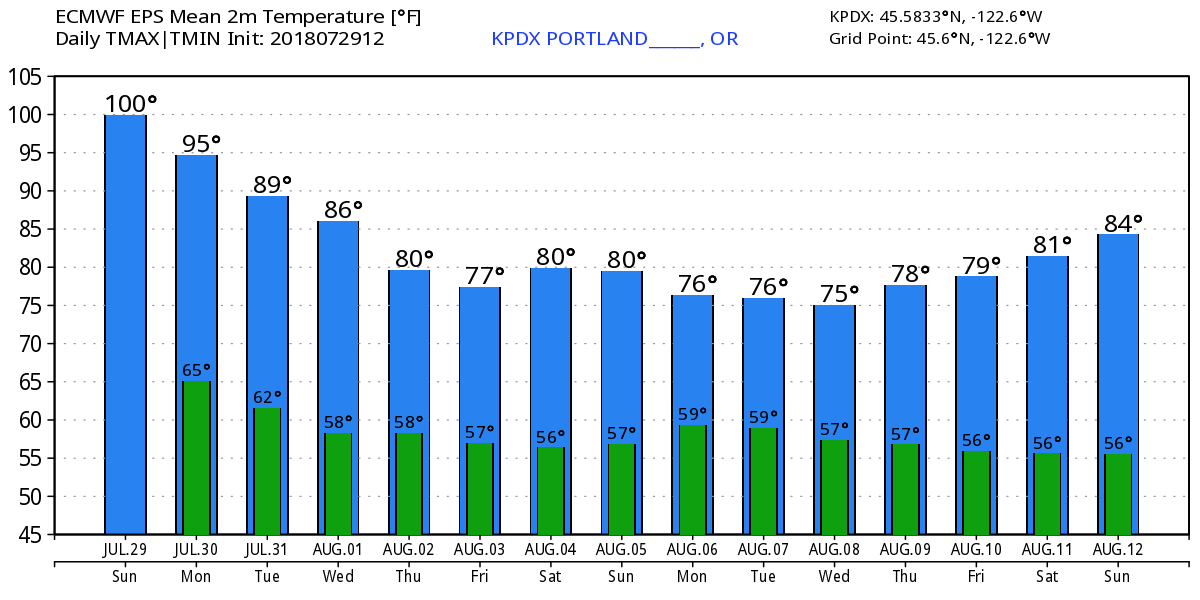
Of course you can probably guess that we can forget about 90s during that time.  Check out the ECMWF ensembles for temperature…below average for most of the time from this Thursday through the following 7 days.

KPDX_2018073012_eps_min_max_15

Does this mean all of August will be cloudy, cool, & showery?  Absolutely not, but it’s very clear the first 10 days of the month will be far different than July!

Chief Meteorologist Mark Nelsen


Heatwave Update: 2 more days plus fire smoke Monday

July 29, 2018

8:30pm Sunday

Yesterday was “reasonably hot” but today the furnace went into “hot blast” mode, hitting 99 degrees in both Portland & Salem.  It was the 2nd hottest day of summer here in Portland.

Todays Observed Highs OrWa 2017

The Dalles and Hermiston both hit at least 107, both the hottest so far this summer

Todays Observed Highs OrWa 2017_2

That puts our streak of 90 degree days up to 8.  That’s rare in Portland

High Temp Last 13 Days

Note we’ve only had one longer stretch…10 days during that brutal July 2009 heatwave.  That year we hit 106 on two consecutive days with lows above 70 for two nights:

90 degree streak history

We didn’t have any offshore flow today, no easterly wind to help drive temps to 100, or higher.  That’s been something interesting about both heatwaves this summer; even with weak onshore flow we’ve been able to get close to or hit 100 degrees.  I’ve been forecasting in Portland coming up on 27 years this fall…seems like it’s “easier” to get hot weather nowadays with the same upper-level setups.   That said, it was +23 deg. Celsius when the weather balloon hit the 850 millibar level about Salem this afternoon.  It doesn’t get much hotter than that.  Easterly wind would have pushed us up into the 101-103 degree range.  Luckily we didn’t get that.

Tomorrow there will only be minor changes.  First the upper-level atmosphere cools just slightly.  Then the onshore flow should be just SLIGHTLY stronger; although I doubt that’ll change much except drop temps maybe 5 degrees.  The 3rd?  Fire smoke is on the way.  Upper-level wind has turned southerly the past 6 hours, which “opens the door” for all those fires in southwest Oregon and northern California to send their smoke northward.  This image is from midday today.  But I can now see the thick smoke approaching from the south on our Skyline Camera.

Mark Smoke FireOrigin

The HRRR experimental smoke modeling shows that it reaches the Columbia River before sunrise

trc1_t1int_f10

Yuck…expect a sickly yellow-ish sun in most of Oregon and the southern edges of Washington Monday.   As we saw a couple of times last summer, a thick layer of smoke can drop the temperature well below the forecast high.  If the smoke suddenly thickens during the night, it could keep us even warmer than forecast during the nighttime hours.  We’ll see how that turns out tomorrow.

Regardless of exact high temp Monday, we’ll see our 15th day of the month at/above 90 degrees.  We’ve never seen more than 14 in any one month; that will be a new record for PDX

90 Degree July Days

When do we cool off?  All models are in very good agreement that we see some significant cooling Wednesday, down into the 80s.  But wait, an upper-level trough swinging through gives us a big marine push for Thursday & Friday.  Those days could be at least half cloudy with morning clouds lingering until at least noon.  Yes, it’s possible we get a few days only in the 70s…a glorious start to August.  In fact it’s quite interesting that just as August begins on Wednesday, we go into a much cooler weather pattern.   Take a look at the ECMWF ensemble temps for Portland:

KPDX_2018072912_eps_min_max_15

This implies the first 10 days of August will actually be BELOW average with plenty of cloud cover.  A huge change.  One more thing, 45 of 51 ECMWF ensemble members give us some significant (think spring) showers the early/mid part of NEXT week. It’s centered around the 6th-9th of August.  I’ll take a closer look tomorrow, but this could impact agricultural interests that are used to dry conditions in early August.

Try to stay cool on Monday!

Chief Meteorologist Mark Nelsen


Heat Wave Day #5: More Humid & Warmer Nights Ahead, Then It Gets Better

July 26, 2018

5:30pm Thursday…

It’s ANOTHER scorcher out there folks.  I see it’s 95 on the roof of the FOX-12 broadcasting fortress (business park building).  Officially here in Portland we hit 96 degrees this afternoon, that’s our 5th day into the mid 90s.

Let me throw a whole bunch of hot numbers at you…

This slideshow requires JavaScript.

10 of the last 14 days have stayed above 90 here in Portland

High Temp Last 13 Days

This is our 16th day at/above 90 degrees this summer, we’re headed for 20-21 by the time this heat wave ends!

90 Degree Days Summer Heat

Of course you may be wondering if we’re breaking any sort of “consecutive 90 degree days” record?  IF the last 90 degree day is Monday, we’ll be at #9.  If we still reach 90 on Tuesday, we’ll tie the all-time record of 10 days at/above 90 set during the 2009 heat wave.  Remember those back to back 106 degree days?  95 doesn’t seem so bad now does it?

90 degree streak history

WHAT’S AHEAD THE NEXT FEW DAYS

  1. A slight cool-down Friday/Saturday due to a very weak seepage of marine air into the western valleys of NW Oregon and SW Washington…high temps drop closer to 90.
  2. Hotter again Sunday/Monday as weak onshore flow ends.  We could hit 100 on Sunday…for sure it’ll be between 98 and 102 that day.  That’s assuming we don’t get a bunch of thick fire smoke.  Speaking of…
  3. On Sunday, and possibly Monday, all that fire smoke plaguing SW Oregon may move north on southerly upper-level winds.  Could be a very smoky/hazy day or two.  Westerly flow returns later Monday/Tuesday and that would clear us out again
  4. Higher relative humidity.  Models are all showing rising dewpoints (measure of moisture in the air) both Sunday and Monday.  Most likely due to the slight influx of marine air plus southwesterly flow developing overhead as the strong ridge rebounds just to our east.  This means not only hotter weather Sunday & Monday but more humid…yuck!
  5. Warmer nights.  A hotter airmass plus more humidity means our current low-mid 60s low temps will warm another 3-5 degrees.  The result will be lows closer to 70 in the Portland urban areas Sunday and/or Monday mornings.  2nd yuck!

Try to stay cool the next 4-5 days…getting into water is an excellent idea…check out those river temps!

MarkRiverTemps_MoreMetro

Speaking of water, two years ago I picked up a smokin’ hot Craigslist deal.  A nearly new pool someone wanted to unload quickly at less than 1/4 the original price.  Those are the best few hundred dollars I’ve spent!  This is my new mid-summer “pre-work” exercise routine…

IMG_2691

Chief Meteorologist Mark Nelsen


Good News! GOES-17 Problem Not As Bad As Feared

July 24, 2018

6pm Tuesday

It appears what could have been a major problem for future West Coast satellite imagery has been turned into a minor issue…we hope.

The first of a new series of advanced geostationary weather satellites was launched last year.  It was named GOES-16.  After a period of testing, it was moved into the GOES-EAST position off the USA east coast last December.  These new satellites have far greater temporal and spatial resolution, plus a bunch of new sensors with new capabilities.

In early March a sister satellite, GOES-17 was launched.  The plan is for a few months of testing and checkout, then a move to the GOES-WEST position off the West Coast this fall.

But once the satellite was launched, engineers discovered a huge anomaly.  The ABI (Advanced Baseline Imager) has a “cooling problem”.  It’s similar to a radiator not working properly and allowing your car engine to overheat.  In May NOAA/NASA announced the Infrared imagery could possibly be unusable for half the day.  Specifically at night when the sun is behind the earth and looking directly into the imager.  Bad news!

Mark GOES 17 Problem Fix1

Keep in mind that GOES-15 continues to operate faithfully in the GOES-WEST position.  But there has been a real possibility that the western half of the USA could be left without a new/advanced satellite for another 2-3 years.

All has been quiet for two months but just today NOAA/NASA announced via a teleconference that things are looking better.  Specifically, through lots of tweaks, software changes & hard work:

  1. 13 of the 16 sensing channels on the ABI should be available 24 hours a day during the solstice periods (summer & winter).  The other 3 channels should work at least 20 hours of the day during these times.
  2. 10 of 16 channels should work correctly 24 hours a day during the equinox periods (early spring and early fall).
  3. This only affects IR and near-IR imagery
  4. All visible & water vapor imagery is unaffected (good)

Mark GOES 17 Problem Fix2

Again, this doesn’t affect many of the sensors, including the new Global Lightning Mapper instrument:

You may wonder why it would be different depending on the season?  It turns out the sensor runs “coolest” during the solstice times (June & December) when the sun is not pointing directly at the sensor during the night.  Near each equinox the sensor more easily overheats with too much incoming solar radiation pointing directly at it from behind the earth.

It was also revealed at the press conference today that GOES-16 has experienced a much smaller version of this same problem.  Luckily it hasn’t impacted performance on that satellite so far.

Due to these issues, most likely GOES-S & GOES-T will likely be delayed as engineers try to fix the cooling issues before launch.  They were scheduled to be launched beginning in 2020.

The best news?  Barring any further problems, GOES-17 will make the move westward this fall and be in place at 137W longitude for this coming storm season.  It will be renamed GOES-WEST at that time.

It’s probably too early, but I’ll say WHEW!…for now.

Chief Meteorologist Mark Nelsen


Heat Wave #2 Rest Of This Week

July 22, 2018

9pm Sunday

Back from a nice vacation this evening and heat is back as well.  We hit 94 in Portland today, which means we have just about had our “typical allotment” of 90 degree days.  We average 13 days per year at/above 90 in our area…but we’ve definitely exceeded our average 4 out of the past 5 years

90 Degree Days Summer Heat

We are up to #12 already this year with another 7 likely on the way.  You aren’t crazy, we HAVE seen a string of hot summers starting in 2014.  Of course 2016 was only a bit above average but it has been ridiculously hot otherwise.

We had a nice cool down Wednesday through Saturday after that 7 day spell of hot weather:

High Temp Last 13 Days

As of this evening, it’s our 4th hottest July on record in Portland, 10th hottest in Salem.

Why such hot weather?  As mentioned in previous posts this month, upper-level heights have been running quite high compared to normal.  A strong upper-level ridge is centered right over New Mexico right now, which isn’t all that unusual for July.

Jet Stream Forecast 2017

This chart shows the big ridge, centered far to our SE (the lines, not colors).  But most important for us are the warm colors showing that even well away from the big ridge heights are far higher than normal in the Pacific Northwest and British Columbia

m500za_f024_bg_NA

It stays there most of the week but then edges closer to us, centered over Nevada/Utah next weekend.

Jet Stream Forecast 2017_2

That’s why I’ve put in temperatures near 100 again for next weekend.  We’ll see how that plays out.  Most important, the ridge stays nearby and keeps us continuously hot all this work week without any sort of good marine push to bring us cooler ocean air.

Models have been in great agreement showing this pattern.  Check out the ECMWF ensemble 15 day forecast surface temps at Portland:

KPDX_2018072212_eps_min_max_15 (1)

That’s a long hot spell, but you also see some sort of pattern change arriving about the middle of next week (we hope!).  Just as August arrives the ridge seems to want to weaken…maybe.

By the way, my family and I just spent two days at Waldo Lake…hadn’t been down there in almost 10 years.  That’s the 2nd largest lake in Oregon and typically real chilly, but perfectly clear.

photo_waldolake

We got lucky; the heatwave has warmed up the surface to at least 65-70 degrees, maybe even a bit warmer along the edges.  What a beautiful place with no motors and so peaceful as well.  Mosquitoes weren’t horrific, but definitely around.  As always August is better at Cascade lakes mosquito-wise.  Then we spent two nights at Clear Lake…getting pretty low early again this year.

photo_clearlake


Won’t be much left in a few weeks up there, I was almost able to walk across the wide section.  So many beautiful places to visit but just not enough time!…maybe in retirement.

Chief Meteorologist Mark Nelsen


Near 100 Today

July 15, 2018

8am Sunday

Just a quick note to let you know today looks to be a scorcher again, possibly the hottest day of the year in Portland.  For the first time in 3 days light easterly “offshore” wind flow has developed this morning through the Gorge.  That plus a very warm/hot atmosphere overhead and full sunshine means warmer temps than the low 90s from Saturday.  PDX officially hit 93 yesterday.

web_PDXTemp_13days

Today should be around 5 degrees warmer, possibly 7.  Of course that opens up the possibility that we hit 100 degrees for the first time this season.  Here is our morning forecast

web_fcstwest

850mb temps are not as hot as I’d like to see for PDX hitting 100, currently around +20 to +21 over Salem.  It’s a stretch to get that hot down here at the surface with those temps up above.  But considering the sudden surge of heat Thursday with the offshore wind (97 at PDX and 99 at Troutdale), temps around 100 seem reasonable again today.  It sure seems easier to get hot in the Willamette Valley & Metro nowadays doesn’t it?

As I mentioned the last day I worked (Tuesday) we are in this very warm/hot stretch for quite awhile.  By the time we get a major marine push Tuesday night, we will have gone through a 7 day stretch with highs 89 or higher.  All models are in very good agreement we get a nice cool down Thursday/Friday, then warming again (back to hot) for next weekend.  Note both the GFS and ECMWF meteograms from last night’s ensemble runs.  This is for Salem, but Portland is similar:

KSLE_2018071500_eps_min_max_15


KSLE_2018071500_min_max_16

It’s going to end up as another blazing hot July; Portland, Salem, & Redmond are all running 3 degrees or more above average for the month at the halfway point today.  Note the 850mb ensemble chart from the ECMWF shows upper-air temps above average the rest of the month.

tseries_850t_000-360_Portland

I’m on vacation this week, looking for a cool place…stay cool!

Chief Meteorologist Mark Nelsen


Hottest Weather of Summer Ahead

July 10, 2018

8pm Tuesday

Today was a fantastic day in my opinion…clouds to sunshine and temperatures right near seasonal averages.  The Willamette Valley ended up right around 80 degrees.

If you don’t like our mid-summer hot weather, find a cool place; it’s about to get hot west of the Cascades.  A sprawling upper-level ridge is already building this evening over the Pacific Northwest and more or less remains over us the next 7-10 days.

HIGHLIGHTS

A long period of very warm to occasionally hot weather is likely Wednesday through the middle to end of NEXT week.

  1. Every day is likely to exceed 85 degrees, with temps as high as 95 either Thursday or Sunday/Monday.
  2. I think temps up to 100 or higher are unlikely at this point
  3. Overnight lows will be moving into the low-mid 60s at times…getting uncomfortable in the urban areas if you don’t have air conditioning
  4. Record highs are unlikely…all records through the 21st are at/above 101 degrees.

This one is interesting because it’s not a sharp ridge which gives us extremely hot weather and/or easterly downslope wind.  Instead it’s quite flat, indicating a large area of much warmer than normal temps.  Here’s the 500mb forecast from the ECMWF model ensembles (actual heights are the lines, anomaly is the color) for Thursday, Sunday, next Wednesday, and Saturday the 22nd.  No big, hot ridge, but abnormally high heights…seems like a lot of red across a good chunk of North America.

This slideshow requires JavaScript.

850mb temps peak out around +22 Thursday and 19-21 on ECMWF ensembles Sunday-Monday.  Without decent offshore flow it’ll be very tough to get above 95 degrees (good!).

Note the surface temp forecast for Portland from this model

EPS_PDX

These numbers are a good 8-15 degrees above average for our area.  If you are into water sports this is excellent news.  If you work for a paving company…well…October will eventually get here.  We can forget about precipitation because in this pattern even thunderstorms are hard to come by as high heights squash the convective stuff.  Not a single GEFS ensemble member produces even .10″ rain in the next two weeks.  The ECMWF is similar.

GEFS_precip

Of course if we’re going to get an extended very warm to hot stretch this IS the time to do it.  Notice that here in Portland the hottest time of the year is typically the 3rd week of July to the middle of August.

BMAC HEAT OF SUMMER TEMPS

How about the coastline?  Can you escape the heat there?  Yes!  In this pattern we shouldn’t see easterly flow make it to the beaches so 65-80 is a good guess for the next week, depending on location and day

7 Day Coast Plus Cascades Summer

And the Cascade lakes will be an excellent place to be as well as anywhere else at/above 4,000′

7 Day Coast Plus Cascades Summer2

I would suggest Ape Cave or any other lava tube near Trout Lake or Bend…it’s in the 40s year-round in most of those cave since they follow the ground, not air, temperature.

On a “big-picture” note…unless something changes drastically in August, this is going to be our FIFTH warm/hot summer in Western Oregon and SW Washington.  I can’t find any other period in at least the last 100 years where we’ve seen such a stretch of abnormally warm weather.  2015 was the hottest summer on record here in Portland.

SummerTemps_100Years

As mentioned in the past, this is one season in which we are seeing dramatic warming in our area…not so much in winter but in summer.  That doesn’t mean we can’t have a round of cool summers right around the corner, but the trend is definitely up.  That cool summer of 2011 seems a long way back now doesn’t it?

MarkSummer RecentYears

Chief Meteorologist Mark Nelsen