81 in Portland Today, New 80 Degree Record

September 29, 2015

We did it.  Not only did we set a new record for 90 degree days this warm season; but now we’ve exceeded the all-time number of 80 degree days.  With a high of 81 that makes today day #85 this year.

MarkTemp_wCamera

For those of you tired of sunshine and above normal temps…at least you had a relatively cool September.  Here are the average dates for “Last” days in Portland.  Things cool off quickly in October!

MarkLast80_90_70Days

Chief Meteorologist Mark Nelsen


80 Degree Record Tied

September 28, 2015

We hit 81 in Portland today, which ties the old record for most 80 degree days in one season.  During the blazing hot summer of 1967 we had 84 days at/above 80 degrees.  As of today we’ve seen 84.

MarkHeatwaveStudio_80DegreeTemps

One difference this year compared to 1967 is that the heat arrived much earlier.  That year it was July/August, this year it was mainly June/July.  August was warmer than normal but not a crazy hot month.  September will end up slightly below average.

Note we’ve seen DOUBLE the number of 80 degree days as in the cool summers of 2010-2011.

Tomorrow we should hit 80 again but that might be it for the season.  The pattern still looks ridgy the first part of October, but that doesn’t mean we’ll hit 80 again.

Chief Meteorologist Mark Nelsen


ECMWF Monthly Run

September 28, 2015

Maps ahead for the real hardcore weather geeks only…

Interesting turn of events with the ECMWF over the past few days.  It’s now showing ridging returning earlier than expected. In the monthly run one week ago it was showing ridging after the first week or so of October.  Now it’s pretty much from here on out through the month of October.  Here are the 4 weekly maps showing upper-level ridging hanging around the region for the next 4 weeks.

500za_week1_bg_NA

500za_week2_bg_NA

500za_week3_bg_NA

500za_week4_bg_NA

I can’t show you the maps (legal issue), but the total precipitation (ensemble average) is only around 2″ in the next 32 days here in the valley.  The control run (higher res) shows 3-4″ during that period.  Surface temperatures are above normal, when all 32 days are averaged, in both control and ensembles.

What a pain to forecast this coming weekend.  The GFS builds a ridge quite close to us, but the ECMWF and GEM (Canadian) both bring a cold trough down over us Saturday.  It leaves quickly, but these models would imply 60-65 degrees on Saturday with a few showers, whereas the GFS says about 85 and sunny with strong easterly wind.  I went in the middle for now.  You can sure see the disagreement even among just the ECMWF ensembles:

tseries_850t_000-360_Portland

Chief Meteorologist Mark Nelsen


What is a Meteorologist and What is that Logo?

September 27, 2015

We were having a discussion in the news studio the other day about the definition of a meteorologist and how it relates to the small logos (known as a “seal” in the business) we show near our names.  Just from the discussion it was obvious there are some misconceptions about both, so here are my thoughts:

Is your TV weather person a meteorologist? It depends on your definition!  THERE IS NO LEGAL DEFINITION OF A METEOROLOGIST like with lawyers or doctors…it’s not the same.  The traditional and first definition; a meteorologist is a person that goes through 4 years of college and gets a Bachelor of Science degree in Meteorology.  Or in my case it was called Atmospheric Science (at the UW).

The American Meteorological Society (AMS) has a long two paragraph definition.  It includes the 4 year degree path but also gives a 2nd definition: …(individuals who have) gained sufficient knowledge through coursework and/or professional experience to successfully fill professional positions, such as military weather forecasters or positions typically held by degreed meteorologists.  These individuals can also be referred to as meteorologists.  This includes individuals who have obtained and maintain either the AMS Radio or Television Seal of Approval or the AMS Certified Broadcast Meteorologist designation.

This tells me anyone who has taken some sort of coursework and/or has regularly worked in the TV world can sure be called a meteorologist.  As a result, I no longer get into arguments about who is and who isn’t…generally.  That said, it’s pretty obvious who should not call themselves meteorologists.  Again, from the AMS definition:  …Individuals who have little formal education in the atmospheric sciences, and who disseminate weather information and forecasts prepared by others, are properly designated weathercasters.  If you’re just ripping & reading and have never taken a single class in meteorology, you shouldn’t be using the term.

Without naming names, which would be unprofessional (and obnoxious), I think there are 4 degreed meteorologists in Portland TV (full or part-time).  One of those is me.  Most of the rest of the broadcasters are in that 2nd category mentioned above.  Those that don’t have the degree are often great forecasters that love their jobs and no different from me.  They just didn’t get all the final math/physics that is required for the B.S. degree.   Most were also journalists first and then went into weather.  Management loves that because then you can be used for either weather OR reporting.  Many folks have gone through the Mississippi State Certificate of Broadcast Meteorology program, which is pretty in-depth from what I’ve seen.  As for the “weathercasters”, as far as I’m aware there are only 2-3 people (out of ~16) doing weather on Portland TV (regularly) that have no training of any sort in weather/meteorology.

So there you go…that’s the meteorology story.

What about those seals?   There are three you might see on Portland TV.

1. The old AMS Seal of Approval (not issued after 2008)

AMSseal

This was the standard for many years.  The AMS issued these from 1956 until around 2008.   I think there are one or two people at each station that have one of these.  You can search for your favorite weather person here:  http://www.ametsoc.org/memdir/seallist/get_listoftv.cfm

2. AMS Certified Broadcast Meteorologist

CBMlogo

This was introduced in the late 2000s…because requirements for the old AMS seal were relatively loose.  You just had to send in a tape and show that you had some meteorology education.  As long as you seemed relatively competent, you passed.  That said, I flunked the first time in 1994 or so…hmmm.   I passed the 2nd time around 6 months later.  The new AMS Certified Broadcast Meteorologist seal more or less requires the full meteorology degree.  It also requires a test and continuing education/portfolio requirements that was not required in the old seal.  Only 2 of us in Portland have this seal.  You can search the list here:  I happened to be on the Board of Broadcast Meteorology when this was introduced.  They “strongly recommended” we get one so I was quick to jump on it.  In time, this seal will become more valuable since the other is no longer offered.  That’s making the HUGE assumption that local TV news will continue in its current form.  Seems very unlikely in our current online world.

3. NWA Seal

NWA

The National Weather Association also has a seal of approval program, similar to the AMS seal.  You take a test and submit tapes, similar to the AMS CBM program.  You can find a listing here.  I didn’t spend much time on the site, but I’m not aware that anyone in Portland has an NWA seal.  Maybe one.

A couple final thoughts:

  1. Having/not having a seal doesn’t mean you are/aren’t a meteorologist.  They are not directly related to each other.
  2. Bosses along the West Coast, where the weather is very mild much of the time, are not as concerned with a person’s credentials or professional seals.  We are more personality-driven.  It’s a much bigger issue in the severe weather parts of the country.  I know of some locations in the Midwest where you won’t get a TV job without a seal.

Hopefully I’ve cleared things up a bit.  If you have any other questions I can answer them below.

Chief Meteorologist Mark Nelsen


Sunday Evening Eclipse: Clear Sky Expected

September 25, 2015

There will be a total lunar eclipse at a convenient time along with clear skies…what could be better?

Sunday evening we’ll be treated to not only a total lunar eclipse (not TOO uncommon), but a “super” moon at the same time.  That hasn’t happened in many years.  What does it mean?  A good evening to go outside and check out the sky.

A total lunar eclipse happens when our shadow passes over the moon.  That means if you are on the moon you would see earth passing in front of the sun.  The progression is something like this image from Sky & Telescope magazine:

Fujii_Eclipse-1024x496

In the case of Sunday evening, the eclipse will have almost reached totality when the moon rises over the Cascades (when viewed from the western valleys of OR/WA).  Then just 15 minutes later we’ll be in totality…for the next hour and 12 minutes.

MarkTotalLunarEclipse1

After that time a bright slice of the moon will appear and gradually grow larger over the following hour or so as things return to normal.  So what about the SUPER part?  Well, there’s a bunch of media drama there because it’ll barely be noticeable as this graphic shows:

MarkMoon_Huge

There is a 14% size difference between full moons.  I bet you didn’t know that!  It’s because the orbit around the earth is slightly elliptical, not a perfect circle.  The difference between the closest and farthest moon locations is only 30,000 miles, so our eyes can’t even tell the difference from one full moon to the next.  It’s interesting to note that the term SUPER MOON existed from the last 1970s to the late 2000s, but hardly anyone had heard about it until 2011 when the media picked up on it.

Finally, it is sometimes called the “Blood Moon” because of a reddish hue during totality.  That’s due to light from earth’s atmosphere filtering onto the surface of the moon.

Umbra_color_schematic

The weather looks excellent Sunday evening with mainly or all clear skies across the entire Pacific Northwest.  Enjoy the show!

A far more detailed explanation of all this is at Sky and Telescope’s web site.  It’s a great one to bookmark for future events.

Chief Meteorologist Mark Nelsen


Fire Season 2015: It Could Have Been Much Worse!

September 24, 2015

One month ago the Pacific Northwest fire situation was bleak with almost one million acres burning in Oregon and Washington forests and range lands.  But today, what few fires left are just smoldering and no significant acreage has burned in many days.

We’ve known since mid-spring we could be facing a very bad fire season…consider the setup for the “PERFECT FIRE SEASON”

  1. Moderate to severe drought across much of the region has continued from one to several years
  2. The worst snowpack in MANY decades last winter/spring for much of the region’s mountains.
  3. Temperatures were warmer than normal from winter through early summer; causing what little snowpack remained to melt quickly.  Soils dried out quickly as well.
  4. June was the warmest on record for much of the Pacific Northwest, with a severe heatwave at the end of the month.  Remember the 110+ temps in the Columbia Basin?

By late June, during that big heatwave that went on for about two weeks, I figured it was going to be REALLY BAD in July and August.  But July came and went without any big blowup of fires.  As of late July, acreage burned across the Pacific Northwest was below normal!

What happened?  We were blessed, or lucky, or whatever you want to call it, by two big changes from previous fire season

1. Far less lightning this summer

Take a look at the past 8 years worth of lightning strikes in Oregon and Washington:

MarkThunder_LightningStrikeNWSummer

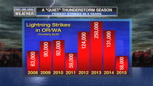
So far, less than half what we saw in 2014, and only 25% of the action two summers ago!  And according to the BLM the largest “event” consisted of just 6,400 strikes.  The past two summers we saw peak events in the 21,000 to 38,000 strike range.

2. Cool with rain late August/September

What a change from warmer than normal to a bit cooler than normal in September!  Quite a refreshing month.  We’ve gone through 4 warm/hot Septembers and now it’s payback time.  Note we’ve seen the fewest 80 degree days this month since 2010.

NORA 80 IN SEPTEMBER

There hasn’t been a ton of rain, but several showery periods east of the Cascades along with snow at mid-month above about 6,000′ in Eastern Oregon has done the trick!

This is how the acreage burned looked as we went through the fire season (thanks to the BLM folks, click for a larger view):

Fire_AcresBurned

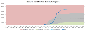
Note the below normal numbers, then the huge jump in August, then leveling out in September.  We’re pretty much done with fire season now.  Of course we can still get fires in October, but not the huge ones we see in the summer.

One more interesting chart, showing the acres burned per week:

Fire_WeeklyAcresBurned

You see the weekly numbers jump in mid-late August, then a big crash.  I don’t understand why there is a jump of 150,000 acres only a week or two ago because I don’t remember any big new fires during that period.

In the end, Fire Season 2015 will end up with above normal acreage burned…definitely a big fire season with lots of homes burned.  But almost all the action happened during a one month period in August.  I think it could have been far worse!

Chief Meteorologist Mark Nelsen


A Pretty Bad Climate Model Forecast

September 23, 2015

I just saw this on WeatherBell’s site this morning.  Back in July the CFS model was showing the hot summer continuing into a very warm September.  Considering fires were just getting going and we were so dry, this looked really bad with ridging continuing:

cfs_sept

But look at what has actually happened:

actual

The exact opposite.  A spectacular failure in the 2 month time frame eh?

On the positive side, it brought the fire season to a screeching halt; there are no large fires actively burning in our state.  The 3 “official” large fires are just smoldering and I see Umatilla National Forest has even started the regular fall prescribed burning.  Plus, we were set up for a really bad September west of the Cascades when the unusually dry conditions could have caused havoc with the seasonal arrival of hot easterly wind.  That didn’t happen and now the ground in the woods outside my home is somewhat moist.  Fire season is pretty much over.

Of course the other benefit was a very early start to summer meant an early end too.  Labor Day really was the end of the hot stuff, minus those two days mid-month in the 90s.

For the next two months, here is what the CFS shows:

cfs_anom_t2m_noram_201510_w3

cfs_anom_t2m_noram_201511_w3

Supposedly warmer than normal through November…we’ll see.

Chief Meteorologist Mark Nelsen