7pm Sunday…
I know I’m not supposed to editorialize, but I’ve been enjoying this real nice stretch of spring weather. No real extremes and drier than normal. What about you? Take a look at the numbers.
1. This month has been a bit warmer than normal, but no huge departures from normal. No “April heat waves”. We haven’t hit 80, but lots of mild days/nights. Two days at 70+ so far

Most of the western USA has been warmer than normal this month as well

2. The “faucet” has just about shut off; we’ve seen very little rain in the last 10 days. Not much is on the way for the next 7-10 days either. Unusual for late April, but not unheard of.

It’s interesting to see a huge gradient in monthly rainfall from dry western Washington down to a very wet central/southwest Oregon. That’s due to the atmospheric river event that lead to flooding around the 6th-9th just to our south. Gray/red colors are drier than average, green/blue wetter. In fact blue is 180% of average or higher.

3. Refreshing and cool nights have returned. After lots of warm nights the first part of April, we’ve cooled back to near/below normal with more clearing. Last night was extra cold, with lots of frost in outlying areas behind the cold front that passed through early Saturday. Never set out your tomatoes/peppers this early in our area. Always wait until sometime in May unless you have them protected well and/or live right in the urban areas.

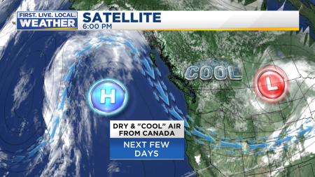
What’s ahead? More of the same for at least another week. It’s interesting to note the cool/dry air coming down from the north plus upper-level ridging just offshore is quite similar to the cold pattern in February. Havre, Great Falls, & Cut Bank Montana were near/below freezing with snow all day today along with a strong northerly wind. Wind chills in the teens…rough life on the Great Plains!
The pattern may be similar, but it’s late April now and the sun is far stronger. That’s why we are seeing colder nights, but daytime highs still made it above average. You can see the effect at 3,700′. Lots of bare areas have appeared on the lower slopes of Mt. Hood Ski Bowl at Government Camp. Alpine Slide is scheduled to open Memorial Day. Clearly this won’t be one of those years when the workers are shoveling it out in June!

Ridging breaks down later this week, but most of the next 10-15 days models are showing upper-level heights in the atmosphere overhead remaining above normal. Briefly below normal about a week from now on the ECWMF

Then back to warmer (higher heights) again the first full week of May

Ensemble forecasts of total rain from both GFS & ECMWF give us around 1/2″ in the western valleys of Oregon & SW Washington through the next two weeks. That’s well below average for early May
But as we’ve seen in early April (with the heavy rain), and February (with cold/snow), models sometimes have trouble seeing general pattern changes more than 10 days out. So I feel comfortable saying we will be unusually dry for another week or so, but not comfortable telling you that will continue beyond May 8th or so.
Big picture…get your decks stained, lawns mowed, gardens cleaned up, and enjoy the dry spring weather!
Chief Meteorologist Mark Nelsen


 Posted by Mark Nelsen


