4:30pm Saturday…
It’s a cold afternoon in Portland; temperatures are right around 40 degrees and the chilly east wind is back. That wind will be very strong the next 12 hours, blasting in a supply of cold eastern Oregon air while milder Pacific air with moisture rides over the top. This IS the classic setup for a snow or ice storm in the Portland Metro area. But in tonight’s case, temperatures are a bit too “warm” for that to happen, plus we don’t have much precipitation on the way.
In the metro area, and through much of the Willamette Valley, we’re going to see at least an hour or two of mainly snow as precipitation arrives. As early as 9pm around Albany to maybe midnight up in Clark County and near the Gorge. But very soon after it starts falling, the air a couple thousand feet up goes above freezing. That means snowflakes melt to liquid rain drops. Of course anyone that is near freezing those first hours could see some snow accumulation; probably less than 1″. That’s most likely out closer to the Coast Range (Forest Grove, Hillsboro, Yamhill, Banks) and hills throughout the Willamette Valley (West Hills, Eola Hills, South Salem hills etc…). But ANYONE could see a quick dusting. Nothing has changed with models today; none showing any significant snowfall. The latest ECMWF model agrees, although I think it’s a bit too dry in general.

Once we go to liquid rain, the remaining “threat” is freezing rain. That cold wind screaming out of the Gorge means most areas east of I-205, and metro hills above 500′ or so (West Hills, Mt. Scott etc…) will drop to freezing. Expect an icy glazing on any outdoor objects in those areas. Although for roads to freeze up, air temps need to drop down to around 30 degrees. That’ll be tough to do except right around Troutdale/Camas and the top of West Hills or Mt. Scott.


All the rest of the Willamette Valley should escape freezing rain and/or more than a dusting of snow. 95% of us won’t see any effect on our daily lives tonight or Sunday.
The cold east wind continues Sunday, but temperatures rise to around 40 degrees in the metro area. Any icy roads near the Gorge should slowly thaw by midday, and the rest of us will just see bare and wet or dry roads. Your life can continue as planned Sunday in MOST of the metro area. For sure after 10am even in those colder icy spots.
In the Columbia River Gorge, expect snow at first, then warmer air overhead west of the Cascades (around Multnomah Falls westward) changes that snow to freezing rain. Late tonight and tomorrow morning I-84 may be very icy from Troutdale to mid-Gorge, then snow-packed roadway beyond that point

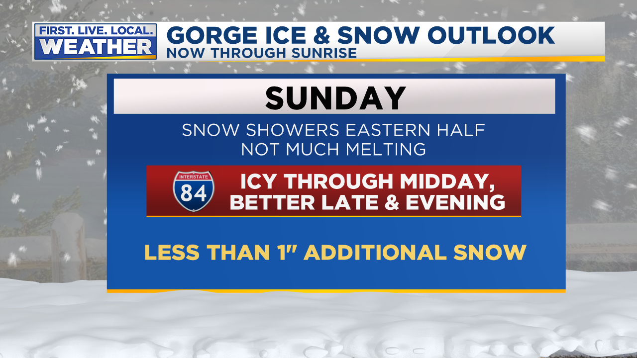
With easterly flow continuing tomorrow, temperatures will only crawl a few degrees above freezing so I-84 ice/snow will be slow to melt off the roadway. Keep a close eye on ODOT cameras and TripCheck. Plus FOX12 will be on the air with Good Day Oregon at 6am. Monday would be a much better day to travel through the Gorge; or consider going over Hwy 26 around Mt. Hood. No freezing rain and snow level near 4,000′ means not much snow/ice once you get below the summit on the west side of the passes.
For the weather geeks
As you can see, no big changes to my thinking. I’m watching those temperatures/dewpoints closely this afternoon. A good guess for how much the temperature will fall with evaporative cooling tonight is to take 1/3 of the temp/dewpoint difference and subtract it from the current temp. For example, right now Troutdale is 39/17. That’s a 22 degree difference. 1/3 of that is about 7. Take 7 off the 39 and you get about 32 degrees once evaporative cooling has kicked in. Subtract another 2 degrees since it’ll probably be around 34-35 when precip starts in Troutdale; so maybe we bottom out around 30 at Troutdale later tonight? That’s why I’m thinking there may be some icy roads that close in to the metro area. Same temperature setup up on the West Hills and Mt. Scott. Farther south in the valley dewpoints are higher so it will be tougher to get down to freezing.
WRF-GFS soundings continue to show quite a warm layer surging in overhead right after precipitation begins. It’s almost a perfect “snow sounding” at 10pm over Portland

Then a sharp warmup around 2,000′ overhead by 1am (near freezing at the surface though with cold Gorge outflow). This is a freezing rain setup, if your neighborhood is at/below freezing. Otherwise a real nice 35 degree rainy night…

ECMWF and GFS both show the warming up around 925 mb as well. That’s why I’ve been leaning more toward liquid precipitation instead of snow since yesterday.
The latest WRF snow forecast confirms little/no accumulating snow west of the Cascades, best chance for an inch would be in those previously mentioned communities right up against the Coast Range east slopes. That shows up on this graphic. Dallas, Willamina, maybe Yamhill?

That’s it for now. I’ll be on the air at 8 & 9pm on FOX12PLUS, then 10pm on FOX12.
Chief Meteorologist Mark Nelsen


 Posted by Mark Nelsen


