Hawaiian Hurricanes

August 30, 2016

5pm Tuesday…

This has nothing to do with our weather of course, but there’s an interesting situation going on near Hawaii right now.  Not one but TWO hurricanes (Category 3 storms!) are heading west in the general direction of the Hawaiian island chain.  Madeline and Lester look like a beautiful couple from space:

MarkTropical_HurricaneCentralPacificHawaii_2Storms2

but as you can see from the stats they are both quite dangerous storms that you sure don’t want to see make landfall.   A Hurricane Warning was issued a couple of hours ago for the Big Island of Hawaii. Also a Tropical Storm Watch for Maui county which includes Molokai and Lanai too.

MarkTropical_HurricaneCentralPacificHawaii_2Storms

Madeline has weakened, but still a category 3 storm that should make it’s closest approach (or actually make landfall) late tomorrow night Portland time. If it survives the slightly cooler water and maintains hurricane status AND hits the island? That will be the first time in recorded hurricane history that a hurricane has hit an island other than Kauai. In the past they have always weakened or veered away…pretty hard for a storm to hit those little specks of land! I should point out that detailed records only go back to the mid-1900s.  There is a good chance Madeline just misses South Point, the southernmost point (cleverly named!) of the Big Island too, so there may yet be no hurricane strike.

Check out the historic record of storms that got within 75 miles of the islands, it does not appear to include the last few years though since a tropical storm hit the east coast of the Big Island either last year or in 2014.

image011

Kauai sure seems to like those storms doesn’t it?  Interesting that 3 in the last 50 years have either hit the island or (in Iwa’s case) zoomed very close by.  Also note the storms that HAVE caused lots of damage are those that zoom quickly up from the south (much warmer water) and move north over the islands.  These storms coming from the east have not typically been very strong.

Hawaii often sees little or no hurricane activity because the ocean water is barely warm enough to support these tropical cyclones.  Most of the time the water is around 73-80 degrees, peaking out right around 80 in the late summer.

And THAT, is your Hawaiian hurricane update…

Chief Meteorologist Mark Nelsen


Portland TV Weathercasters: A Mini-Wiki

August 28, 2016

I’ve spent some time over the past 2 years putting together a listing of all the TV weathercasters we’ve seen in this market over the years.  About a year ago I showed you my work so far.  But just this evening I’ve added a few names, updated a couple of folks that are no longer doing TV weather, and cleaned it up a little in general.

I’ve added the length of the Portland TV career for those that made it to 20 years.  It takes some real stamina, flexibility and likability to make it 20 years in any television weather forecasting job.

A few notes:

  • Jack Capell was the undisputed king, lasting 44 years at KGW!
  • Jim Little was the only one (that I’m aware of) of the “20+ year club” to make it to 3 different stations.  Another 3 years and you’ll join him Rod!
  • I’ve only included those that have/had some sort of regular weather shift, not free-lancers or occasional fill-ins.  There must be another 50 of those spread out over the years.  No insult intended if you are one of those folks.
  • The pre-1980 years get a bit more sketchy, probably quite a few missing names there.
  • Please let me know if you are aware of any errors in these charts.  Either via email or in the comments.

Click on each image for a larger view:


3 Day Heatwave Ends Tonight

August 26, 2016

5pm Friday…

97 in Portland today, what a scorcher, especially for one of the last few days of August.  It was our 4th hottest temperature of the summer:

MarkHeatWave_HottestDaysSoFar

The numbers around town so far…

PLOT_Highs_Metro

And for another day the heat made it to a good chunk of the Oregon Coast.

PLOT_Highs_ORWA

Quite impressive considering the flow was just barely offshore this time around.  That airflow is now turning to “onshore” which means air begins flowing from the ocean to inland areas.  Yes, that’s what we refer to as “nature’s air conditioning”.  Expect a huge drop in temps tomorrow as a result.  Down a good 10-15 degrees for most of us and a solid 20 degrees at the coastline (in spots that were hot today).

Our 90 degree day count for this season here in Portland is now above average (barely) at 14, of which 9 have been this month.

Mark_90DegreeSummerDays

The 30 year average is 13 days (technically 12.9) at/above 90.  In the end, this summer, June-September, will end up being warmer than normal with about the average number of 90 degrees days, maybe another 1-3 coming in September…we’ll see.

Chief Meteorologist Mark Nelsen


YOUR Phone Can Help Improve OUR Forecasts!

August 23, 2016

Do you use an Android smartphone?  If so, would you consider helping out Pacific Northwest meteorologists by downloading a simple app?

Android-mobiles-1

It appears to be a strange request right?  But let me explain:

Cliff Mass (a professor at the University of Washington) has a project in which he’s trying to test the value of pressure observations from smartphones.  Their hypothesis is that a massive number of smartphone pressures could improve the initialization and forecasts of high-resolution numerical prediction models.  They want to use western Oregon/southwest Washington and the downstream regions (Gorge, Eastern Washington/Oregon) as a test area.  But they need to collect smartphone pressures.  To do so they have developed a powerful app for Android smartphones (uWx), which is available on the Google Play Store (https://play.google.com/store/apps/details?id=com.uwx&hl=en).   The web page for the new application is here: https://www.cmetwx.com/.

In addition to collecting pressures, uWx provides wonderful forecasts, full resolution radar, and even accurate elevations for hiking.  So in exchange for providing that information you do get a nice little weather app as well.  Cliff tells me they really need observations from the Portland metro area and Columbia River Gorge.  So please help out if you can.

The app is not available for iOS (Apple) phones for now.

Cliff has done a blog posting about the project as well here:  http://cliffmass.blogspot.com/2016/07/innovative-new-weather-app-observes.html

Chief Meteorologist Mark Nelsen


The Great USA Eclipse Is Just 1 Year Away

August 21, 2016

Sunday 9pm…

We are less than 1 year away from the biggest astronomical event Oregon has seen in over a generation.  There will be a total solar eclipse in our state from 10:15-10:30am on August 21st, 2017.  That means Oregon will be cut in two by a ribbon of total darkness for 2 minutes.  The shadow of the moon will pass along a line from Depot Bay to near Ontario.  It will continue all the way into the SE USA by early afternoon.  This will be the first time since 1979 that we’ll see a total solar eclipse here.  And it’ll be quite awhile until we see another, although it’s interesting that one spot in the SE part of the country will see TWO eclipses within a span of 8 years since there will be one more eclipse back east in 2024.

eclipsepaths

Assuming skies are clear, the sun will look like this for about 2 minutes along the “line of totality”:

solareclipse

I think this web site is excellent, showing detailed maps of where you want to be for those two minutes:

http://www.greatamericaneclipse.com/

And here is their map of the path.  Notice how narrow the “zone” will be: Stayton and Madras are perfect, but it’ll be useless to be in the Portland metro area or Bend, they are outside of the path and it will not be totally dark.

TSE2017_Oregon

A real neat detailed pic from the same website (click for the best view):

2017_LongMap_125dpi

Rumor says most or all hotels have been booked up for next year for quite awhile.  I’ve also heard much of remote Olallie Lake Resort is even booked!  There is “no room at the inn” apparently in Madras where thousands (or many tens of thousands or a hundred thousand) will be congregating for the two minute show.  Madras & Mitchell have the sunniest weather, on average, anywhere in the USA for this eclipse.  I’ve even heard a rumor that there could be an extra million or more people congregating on that strip in Oregon that morning.  Sounds like a traffic nightmare maybe?  It is interesting that the two big state parks under the totality with a good chance for sunshine can’t be booked until late November (9 month window).  I wonder how many people will be clicking like crazy on the Detroit Lake and Cove Palisades State Park website reservations on a cold and rainy November morning?

Anyway, read up the eclipse and make your plans!

Chief Meteorologist Mark Nelsen


Record High Temperatures

August 20, 2016

7am Saturday…

What a scorcher yesterday, as expected.  The highlights (thanks to Portland National Weather Service):

recordhighs

Click on these for the full image…

A few notes:

  1.  Friday was the first time we’ve reached 100 in late August (or September) since 1988!  It’s rare to get to 100 this late in the summer season as the sun angle gets lower and nights longer
  2. Astoria just experienced its hottest day in 55 years!  2nd hottest on record at Astoria airport since records began there in 1953.  It hit 100 in 1961 at that location.  Other locations in the Astoria climate record show temps warmer than 98…that was a cause of some self-induced Twitter drama on my part yesterday.
  3. Notice some spots in the north Willamette Valley and Clark County were slightly cooler today?  That was due to the east wind being a little “too strong”.  Slightly cooler air coming in from Eastern OR/WA.  That’s a really tough call in the forecast.  The areas that already had the NE wind Thursday were slightly cooler Friday. Interesting that some models picked up on it.  I think the WRF-GFS and ECMWF had hinted at the possibility.  A very fine nuance to the forecast, but interesting for geeks like me.
  4. 850mb temp over Salem hit +23.4 degrees yesterday afternoon, down just a degree from Thursday afternoon.  Yet some temps warmer in the valley/coast shows what the offshore wind flow can do.  Now image if we would have reached +27 degrees instead!  That’s what happened in mid-August 1977 when PDX hit 105 and some valley locations even warmer.

Here’s an interesting tidbit of hardcore PDX climate info, from Chris Callais over on both weather Facebook groups…yesterday appears to have seen the 2nd warmest noon temp we’ve seen at PDX:

chriscallais_noontemps


We’ve got one more scorcher today and then Sunday looks wonderful with strong onshore flow.  Troutdale profiler at 6am shows (weaker) offshore flow still going:

Capture

It is slightly cooler in the lowest 1,500′.  Hmmm, might just be a 97-99 degree day instead.  That’s quite possible.  We’ll see.  Either way, one more hot day.  Stay cool!

The lengthening nights sure make a difference on our low temperatures this time of year.  I see some 50s in the outlying areas even under this hot airmass.  And PDX made it down into the lower 60s once the wind disappeared.  Yet in a few breezy spots in the hills (West Hills and Eola Hills near Salem) it only got down into the lower 70s.  Feels like Hawaii!

I see low clouds have returned to the coast so it will be MUCH cooler out there.  If you head out there (along with masses of others), it’ll be in the 60s and 70s…very nice.

Chief Meteorologist Mark Nelsen


Episode 40: The Heat is ON!

August 19, 2016

The podcast is back! Hot weather talk, plus an explanation of our 12 Day Trend. Plenty of laughs too and maybe even a little FOX12 gossip thrown in. Enjoy!

Northwest Weather Podcast

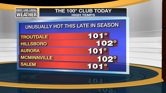
markhot_heatwave_100_temps

It is blazing hot in the Northwest this week, with temperatures soaring to the triple digits around the Portland metro area. On this episode, the guys break down our heatwave and let you know what to expect in the coming days, including some extreme fire danger and really toasty temps on the Oregon Coast.

They also take a close look at a massive wildfire burning out of control near Los Angeles and the devastating flooding in Louisiana.

Don’t forget, we love your weather questions! Track us down on Facebook and submit yours today. facebook.com/weatherpodcast

View original post