Finally Some Winter Chill (And Maybe Snow) Arrives…In February

January 31, 2019

1pm Thursday…

We’ve had all of ONE significant weather event this whole cool season.  That’s 3 months of boring weather since Halloween!  Now as we approach the end of “West of the Cascades Winter” it looks like we finally have something to talk about!  Yes, in our climate west of the Cascades almost all interesting weather happens (in most years) before Valentine’s Day.  This has also been one of our warmest “cool seasons” on record in the Portland metro too.  But beginning Monday we’ll be feeling some much overdue cool temps and crisp days.

I’ll just skip past the snow hype; here are the details…

THE FIRST HALF OF FEBRUARY LOOKS CHILLY!

  1. At this point I don’t see a setup for a snow/ice storm west of the Cascades; not one of those events where cold air pours out of the Gorge and we get a solid/frozen day in the lowlands and the metro area grinds to a halt.  Please don’t abandon your car on the freeway tonight in anticipation
  2. No sign of freezing rain
  3. No sign of a big freeze at this point either
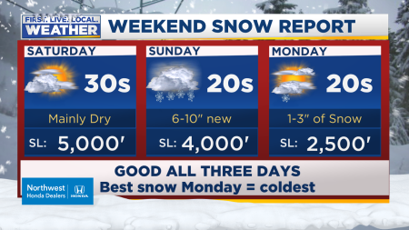
  4. What I DO see is a few “flirtations” with low elevation snow next week, first chance is late Sunday night/Monday AM and again maybe Monday night/Tuesday AM.  Possibly late next week.
  5. If you live near/above 1,000′ you’re almost guaranteed at least some snow at some point Sunday night through Tuesday AM.
  6. NOTHING INTERESTING HAPPENS THROUGH THE WEEKEND, INCLUDING THROUGH SUNDAY EVENING.  YOUR PARTY PLANS AND DRIVE-HOME-AFTER-PARTY PLANS ARE GOOD TO GO.

For now this is all about one of those sloppy wet snow shower events where some of us get it and some don’t.  Some get a dusting overnight and during the daytime most roads are just fine in the lowlands.

LET’S CALL THIS THE ITTY-BITTY POLAR VORTEX 

That’s because there is a small little upper level trough that swings through the Pacific Northwest early next week.  It is a “break-off” of the polar vortex always in place in wintertime across the arctic.  See it on the slide show…use the arrows if you are in a hurry.  See the little cold pool swing down over us?  The timing is Saturday through Monday night with these graphics

This slideshow requires JavaScript.

That pool of air swings out over the ocean.  Then the cold Canadian air picks up moisture at the surface, and moves inland as cold showers.  Of course that very cold air is moving over 50 degree ocean water first which warms up the airmass.  That’s why this weather pattern typically does not bring us snowstorms in the lower elevations west of the Cascades; or even in the Gorge.

Of course this is still 3+ days away so I don’t have any more details for you with respect to how much might fall (if any!) in YOUR neighborhood.  If you’ve seen any snow forecast maps on the internet, don’t get too excited.  Each model is slightly different and I looked at ALL of them this morning.  A few things I notice so far…

  1. Over the past two days models have pushed that cold trough farther west, going out over the ocean as I just mentioned.  This may be due to our general winter pattern (which continues through early February) of weak and “splitty” systems.  Any farther west and we could end up mainly/all dry Sunday through Tuesday.
  2. Models have turned warmer the past 48 hours as well.  The GFS bottoms us out at a “marginal for snow” -7 degrees at 850mb.  ECMWF is now only a -7 to -8 Monday-Wednesday.  They were down around -10 to -12 at one point (mainly ECMWF).  If they back off much further we can say goodbye to snow chances for many of us in the lowlands.
  3. The GFS and GEM, due to the orientation of the upper-level pattern, allow dry and colder modified arctic air to drift into Eastern Washington, come through the Gorge, and into the metro area.  If that occurs, we’ll be REAL cold Tuesday and beyond.  For now I’m discounting that in our 7 Day forecast.
  4. Cold arctic air will be sitting close by (just north/east) for most/all of next week.  Any surface low that develops west of us or comes down the coastline?  We would be in the snowstorm business like late February 2018 or early February 2014.  At this moment I don’t see that on any models.

This next 10-14 days should be real interesting for weather geeks like me; apparently an “end of season” payoff, or at least an attempt at some weather fun.  Take a look at those chilly EURO Portland temps

kpdx_2019013112_eps_min_max_15

The chance for getting SOME snow at SOME point in the next two weeks is the best we’ve seen the entire season.  15 of 21 GFS ensemble members are producing at least 2″ snow (total) in the next 15 days.  At Salem, 40 of 51 ECMWF ensemble members produce at least 2″ snow (total) in the next 15 days.  Odds are definitely looking up

Chief Meteorologist Mark Nelsen


First Snow In Foothills Next Week; Maybe Lower?

January 29, 2019

9pm Tuesday…

A quick post to let you know I’m watching the weather pattern very closely for early next week.  Right now our 7 Day Forecast looks like this:

7 day forecast graphic 2017

Notice there is no mention of snow.  I must be getting old and conservative (with respect to weather).  A few of your weather apps are showing even colder weather than this and snow/rain mixed next Monday and Tuesday.

What’s up?  The ECMWF model started the wishcasting train last night,

WishcastingExpress

showing a cold upper-level trough swinging right down over us Sunday night through Monday night.  The morning run showed the same thing while most other models kept the cold air east.  Well now the 00z runs of the GFS and GEM have come around (at least a bit closer) to a colder solution for that period.  Now all three models show 850mb temps going below the “critical” -7/-8 degree threshold for sea level snow “stickage” from Sunday night through Tuesday morning along the I-5 corridor from Longview to Eugene.  If they maintain that plan for the next 5 days then we’ll see at least snowflakes in the air during that time for the first (and only?) time this season.  Of course that also gives models 5 days to back off.  Or it may just be dry and chilly!

By the way, maybe you’re unfamiliar with the term WISHCASTING?  The ONLY time I’ll ever quote The Urban Dictionary on my blog:

capture


A FEW THOUGHTS

  1. This is not a “snow storm” setup with a cold Gorge wind and incoming moisture.  It’s onshore-flow showers with temperatures just barely cold enough to get sticking down into the cities west of the Cascades.  This is far more challenging to forecast and ALMOST NEVER A BIG SNOW PRODUCER IN THE LOWEST ELEVATIONS.  But hey, we’ll take whatever we can get this winter right?
  2. This is a GREAT setup for those of us around 1,000′-2,000′ to get our first snowfall of the season.  That looks very likely at this time.
  3. It’s still 5 days away; it’s very possible models back off in the next 2-4 days and we just end up with cold rain showers early next week along the I-5 corridor.  That’s why I haven’t changed the 7 Day Forecast for now.

portland snow look ahead

portland snow look ahead2

So again, there sure isn’t anything to “prepare for” in this case.  Just relax and keep a close eye on the forecast the next 3-4 days.

I’m off tomorrow for a family event (saying goodbye to Dad!), but back on Thursday.

Enjoy the next two mild and dry days; they should be great!

Chief Meteorologist Mark Nelsen


January Ends Mild, But Cool February Start

January 28, 2019

6:30pm Monday…

That gusty east wind did the job as we slept, clearing the fog and low clouds.  Most of us woke up to bright sunshine today.  Portland’s high temp surged from low 40s Sunday to low-mid 50s today.  You can see the cool easterly flow affecting the eastern edge of the metro area; Troutdale only hit 48.

pdx observed high today

That hazy sunshine plus breezy east wind continues through Wednesday morning.   Mild temperatures continue as well.  Most of the Pacific Northwest has been warmer than normal this month.

anomimage

This “cool season” so far in Portland has been the 4th warmest.  That’s from November 1st to now.  That explains blooming plant reports.  Looking around my garden/yard it’s as if it just went to sleep a bit, instead of everything totally dying off.  Looks ready to wake up again soon.

You can see the effect on snowpack.  Mt. Hood has now dropped to only 50% of average, with all of the Cascades well below normal for late January

or_swepctnormal_update

So what’s ahead?  Here’s what I see

  1. There is no sign of typical stormy weather in the next 10+ days; models continue the strangely quiet weather pattern through the foreseeable future.
  2. We’ll likely remain drier than normal in early February
  3. Temps cool below average for at least the first week of February
  4. Right now there is no obvious sign of lowland snow, but it’s definitely NOT time to pull out the “winter is over” fork. 

Today there is a strong upper-level ridge along the West Coast, and very cold trough (an extension of the circumpolar vortex) swinging down through the middle of the continent.

jet stream forecast 2017

This pattern was well-advertised by models 10-14 days ago; they did well with the general setup.  I mentioned last Monday that we would watch closely to see if any chilly air drops south this week (or beyond).  Models were hinting the ridging would back off to the west.  Apparently that IS going to happen.  Take a look at the ECMWF forecast for next Monday

jet stream forecast 2017_2

That general setup continues through the 10 day period on ensemble forecasts from most models.  Here’s Friday the 8th, you see the cold troughing over the West and high pressure in the Gulf of Alaska.

eps_500_fri8th

Beyond that, there are hints the ridge moves back over us or very close by.  This is the 15 day forecast for the 12th of February.

eps_500_tues12th

Last night’s monthly run of the ECMWF showed a similar setup with drier than normal conditions for February.  eps_32dayprecipanomaly

This would continue our theme of a “dud” winter; weak weather systems and no stormy upper-level low sitting over the Gulf of Alaska like we’d see in a normal year.

Of course with a cold trough nearby the next 10 days or so I’ll be watching closely to see if any one system digs farther south and/or combines with some moisture to produce snow down below 2,000′.  At this point nothing looks interesting on any model run.  Part of the issue is that we’re in that somewhat dry pattern the next 10 days.  ECMWF gives us only 1/2″ rain in the entire week from this Thursday to Thursday the 7th; the ridging is still quite close to us.

ecmwf_precip_168_portland_41

850mb temps may drop down around -5 to -6, which is great to get a dusting of snow into the Coast Range summits or even as low as 1,000′ west of the Cascades.  The ECMWF ensemble average drops to around -6 next Monday/Tuesday, but it’s also dry during that time.  With onshore flow and showers you need at least -7 to get excited about wet snow on the valley floor.

kpdx_2019012812_z500_t850_360

So if you’re a weather geek like me, keep a close eye on the next 10 days or so.  This is the type of pattern where something could suddenly change and we get a shot of cold air and/or quick snow.  But at this moment nothing specific is showing up on our models/maps.

Chief Meteorologist Mark Nelsen


A Sunny & Warm Weekend; Above the 1,200′ Elevation

January 27, 2019

2:30pm Sunday…

This weekend has been very challenging for forecasters; a classic and very strong wintertime inversion is in place over the most populated parts of Northwest Oregon and Southwest Washington.  The result is a very cool and gloomy day in the lowlands

live cam portland

We expected a mix of fog and sunshine, but assumed the strengthening sunshine would be just enough to “mix out” the lowest elevation moisture and overnight cooling.   “Mix out” means some of the warm and very dry air overhead would mix down into the lowest elevations where many of us live.  Instead the fog/cloud layer is holding strong.

We have a VERY warm atmosphere (for January) overhead.  Take a look at the mountains and beaches.  Temps in the 50s, and a few spots in the Cascade foothills have even made it into the 60s the past two days

This slideshow requires JavaScript.

If it was mid-late February (3 weeks from now), we’d see highs make it into the low-mid 60s in this weather pattern in the lowlands and it would feel like spring.  Instead the long nights are still just long enough to keep the chilly air in the lowest elevations locked in place.  Take a look at the satellite image from midday

capture

Notice you don’t have to go far from the metro area to find bright sunshine.  West of Banks along Hwy 26, anywhere along the coastline or in the Coast Range, or anywhere east of about Corbett in the Gorge.  The Cascades are enjoying blinding sunshine right now.   Both Bend and Redmond have hit at least 66 degrees this afternoon!

What about going uphill?  Check out the spine of Chehalem Mountain sticking out.  That plus the current view from our Skyline Camera

live cam portland2

tells me the fog/cloud layer is about 1200′ thick or so.  Above that elevation you pop out into sunshine.  Unfortunately the vast majority of us west of the Cascades live below that elevation.  This type of forecast (when the fog/clouds break up) is always difficult because models don’t handle the lowest 1,000′ of the atmosphere very well.  In December and January we need some sort of wind, preferably a dry east wind, to blow the fog away and mix that drier air down to sea level.  In February the increasingly strong sun can do it alone.  But in the last 5 days of January it was a tough forecast.

I can GUARANTEE you bright sunshine tomorrow though!  Why?  Cool/dry Canadian air is pushing into Eastern Washington as a strong arctic high surges south into the Great Plains.  By daybreak a strong and dry easterly wind will already be blowing through the Gorge and spreading into the metro area.  If we get any fog/clouds tomorrow morning they will be gone quickly.  Replaced by a windy and sunny day.  The WRF-GFS tends to overdo the metro area wind speeds with east wind, but I think gusts 25-40 mph are likely by midday Monday.

capturewrf

We’ll get the sunshine and warmer temps, but the wind will make it feel chilly in the shade and early/late in the day.  Find a spot facing south and protected from the wind for lunch Monday; then you should have a great time!

Our next good chance for rain is Wednesday night or Thursday.  More on that in blog post this evening… tomorrow.

Chief Meteorologist Mark Nelsen


Winter 2019, A Real Dud So Far

January 21, 2019

7:30pm Monday…

Here we are entering the last 10 days of January and it’s still Dullsville on the weather maps for the next week.  Unless something pops up early-mid NEXT week (more on that in a moment), December and January end up with only one significant weather event.  That would be the January 5th minor wind storm.

It’s hard to believe, but this is my 28th winter forecasting in the Portland area.  Technically I was in Hood River for part of the 1993-1994 winter but it still counts.  Folks, up to this point I feel this is the most boring cool/wet season I’ve seen in my 28 winters forecasting in Portland.  1991-1992 (my first year after finishing college at U.W. in Seattle) was about as slow and so was 2002-2003.  In 2003 at least we saw a few pineapple express events in January.  Regardless, this would be in the top 3 out of 28 on the “meteorological boredom scale” if there is such a thing.

The reason?

  1. Occasional upper-level ridging or split-flow
  2. Systems that come through our area have often been weak
  3. A real lack of cold air behind systems for vigorous/cold showers

A few highlights:

winter so far intro

winter so far recap

The “winter so far” with the +3 degree departure refers to meteorological winter December-January.  We have not seen a widespread Pacific Northwest arctic blast since December 2013.  It’s been 5 years!

Not only has the weather been quiet this season, but temperatures have been unusually warm since Halloween.  Dry as well

winter so far recap2

We’ve done some catch-up in late December and now again in late January, but overall it  has been drier than normal since early November.

WHAT’S AHEAD?

A building upper-level ridge along the West Coast dominates our weather for at least the next 7-10 days, possibly longer.  This has been well advertised by models for quite a while.  A couple of weak systems passing over the ridge give us lots of clouds and occasional light rain tomorrow and Wednesday.  Much of the rain will be focused on the mountains and not lower elevations.  Expect plenty of gloom but not all that much rain Tuesday-Wednesday along the I-5 corridor.

Beyond that the ridge strengthens later this week and through the upcoming weekend.  There are hints that we could see our warmest temps since December; sometime between Friday and Sunday.  850mb temps rise into the teens Saturday and we get weak offshore flow.  We are almost out of “deep inversion season” and we are not starting with a chilly airmass this week.  The result could be high temps one of those days approaching 60 degrees.  It is not unheard of to reach a 60 degree high in late January around here.  And it can happen in this pattern.  Stay tuned later this week for that.

Notice the strong and warm ridge on both GFS and ECMWF ensembles for Saturday:  Spring ski conditions in the Cascades!  Some 60s at the beaches possible as well.

This slideshow requires JavaScript.

Most ensemble runs say this ridging will hold for most or all of NEXT week (through the last day of January).  But you see the ridge moves farther west on both GEM and GFS ensembles?  This is the last day of the month.

This slideshow requires JavaScript.

Several ensemble members want to drop a cold system through Canada much closer to us next week.  If so, we could go from sunny and mild to sunny and cold.  But each run is different; very low confidence at this point.  The ECMWF ensemble temps show a continuation of mild temps into early February

kpdx_2019012112_eps_min_max_15

And westerly (wet) flow returning as February begins…

kpdx_2019012112_eps24_precip_360

WRAPPING IT UP

  1. Drippy and gray next two days
  2. Sunnier and warmer Thursday through at least Sunday, possibly through the last day or two of January
  3. I’ll keep an eye on the middle of next week to see if we’re going to get any last-minute arctic air setup for either cold or snow.  At this point I’m not seeing anything that screams “pattern change”

Chief Meteorologist Mark Nelsen


Another Low Snow Year In The Cascades

January 17, 2019

7pm Thursday…

I feel like we’ve done this before; here we are in mid-January and I’m blogging about low snowpack in the Cascades.

First, we have a great three day MLK weekend coming up for skiers/snowboarders.  There is plenty of snow for everyone:

skiareas

And the only rain should be downpours for night skiing Friday night as a warm front moves over the Cascades.  Avoid that time; the rest of the weekend should be just fine.

snow report 3 days

That’s the good news.  The bad news? “Snow Water Equivalent” in the Cascades doesn’t look so great.

snowpack oregon plus facts

The lack of storminess and warmer-than-average temps has allowed the snowpack (as a percent of average) to drop this month.  Only SE Oregon is in good shape at this point.

It’s ANOTHER low snow year in the Cascades.  I just checked Mud Ridge, at 4,100′ just SE of Government Camp.  This station has seen below average snow water in mid-January 8 out of the past 10 winters!  Only 1 has been above average, and one right at average.  So you aren’t crazy thinking that we haven’t heard about big Cascade snow years lately.  What’s most interesting to me is the total lack of lower Cascade snowfall.  Again this year we’ve rarely seen any snow below 2,500′.  Way down in the foothills at 1,000′, I haven’t seen snow at my home yet this season.  First time that has happened since I moved there in 2004.

So no, this isn’t a horrific snow season like 1991-1992 or 2004-2005, or 2014-2015, but we’re limping along once again.  I see maybe a foot or so at Government Camp coming up Sunday and early Monday, but then mainly dry or even some rain in the mountains the rest of next week.  Anecdotally it seems to me we are getting more ridging the past 10 years than in the past, often centered somewhere near the coastline.

Speaking of…models still show strong upper-level ridging much of these next two weeks.  Check out the ECMWF run showing ridging this next week, and the week following:

This slideshow requires JavaScript.

And you can see the below-average precipitation forecast for the entire West Coast.  California will be drying out along with the Pacific Northwest.  If these maps are correct, January will go out mild and dry.

This slideshow requires JavaScript.

Tomorrow will be a soaker once we get past about 9am.  A warm front with lots of moisture throws steady rain our way all afternoon and evening.  But Saturday is an “outdoor day” since a stationary front sits across southern Oregon.  Most likely the NW tip of Oregon and SW Washington remain dry during the daylight hours.

Enjoy your weekend!

Chief Meteorologist Mark Nelsen


Quick Gorge Snow/Ice Update

January 16, 2019

7pm Wednesday…

Some good news in the Columbia River Gorge.  Well, actually bad news for kids; I think there won’t be an “Ice Day” or “Snow Day” for some of those kids.

We’re only talking a difference of maybe 3 degrees, but that’s enough to take some areas “out of the running” for snow or ice accumulations.

WESTERN GORGE (Corbett to Bonneville Dam)

  • Freezing rain is only likely well above 500′, more like 1,000′ around Crown Point.
  • Most roads will remain clear, ice glazing mainly on trees/objects and not pavement.
  • I-84 REMAINS CLEAR
  • School closures unlikely
  • Highest wind in next few hours, then it backs off a bit after 1-2am

CENTRAL/EASTERN GORGE (Cascade Locks/Hood River/The Dalles)

Light snow at times between now and around 1am, then mainly dry rest of the night

1-4″ with lightest totals down at freeway/river level.

I-84 remains either mainly clear or just slushy

Some school delays/closures still likely here

THURSDAY

  • Light rain and/or freezing rain at times.  Freezing rain spots should be only above 1,000′ in Hood River, White Salmon, & Wind River valleys
  • I-84 STAYS CLEAR AFTER BRIEF MORNING SLUSH

mark gorge wintry weather

Not only are temps just a few notches warmer than I expected 24 hours ago, but this band of frozen precipitation is gone after midnight or so.  The brand new RPM model run for 1am:

rpm clouds rain snow

So there you go, this is still the “biggest snowfall of the season” in the Gorge, showing what a real dud this winter has been so far!

Chief Meteorologist Mark Nelsen