Saturday Update: Hot, but Not Record Setting Next Few Days

June 29, 2013

8am Saturday…

I’m back in town today; a very nice arrival into PDX last night too with temps in the lower 80s.  My wife and I both noticed how “fresh” it smelled when we got out to our car…just that Pacific Northwest summer feel I suppose.

As the PDX NWS forecast discussion says…an interesting forecast pattern the next few days…

The Highlights:

  • A weak push from the ocean last night means a little cooler today, so high temps should drop into the upper 80s, not really hot by Portland standards, but not noticeably different from yesterday.
  • Back to hot Sunday-Tuesday
  • Temps probably top out around 92-95 Monday and/or Tuesday, not record-setting since records are 105-102 for those days!
  • A thunderstorm is possible anywhere inland the next few days, but extremely hard to pinpoint who gets a storm and when


Another very warm night last night, but there is a change that occurred;  cooler ocean air with lower dewpoints moved inland.  I see dewpoints are below 60 here in the metro area.  As a result we’ll probably be just a few notches cooler today even though we are running 5 degrees warmer at 8am.

A blowup of thunderstorms occurred in the middle of the night/early this morning over in northeast Oregon and eastern Washington.  Check out the lightning!  We have a nice deep flow of moisture coming up from the south the next 3-4 days, somewhat unusual for our area.  Sure, a strong ridge of high pressure nearby to keep the action capped most of the time.  But if a disturbance, even a weak one, rides up the southerly flow we could get a thunderstorm anywhere at any time of the day.  Very tough to forecast.

lightning1

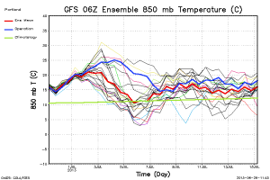
In the past several runs models have really been struggling with placement and strength of the upper level ridge the next few days.   The 00z GFS really backed off the heat, and the NAM is following.  In fact the 12z NAM has us only in the 80s Monday and Tuesday!  The 6z GFS was back to a little warmer and prolongs the warm temps through Independence Day (Thursday).  The old reliable ECMWF, which definitely seems more stable the past few years, is staying with it’s “HOT, BUT NOT TOO HOT” theme for the early part of the week.  Note the 6z GFS ensemble chart first:

tseries_850t_000-384_Portland


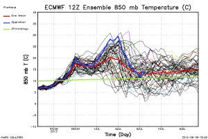
Then the 00z ECMWF:

tseries_850t_000-360_Portland


The ECMWF has been very solid at a +20 to +23 degree 850mb temp peak Monday-Tuesday for many runs while the GFS was swinging wildly out of control.  You can see the operational run (blue) is well above the ensemble mean for the latter half of the week.  It’s a matter of how much of  “dent” we get in the ridging later next week.  The 6z GFS chart is similar with the operational much warmer than the rest of the members.  The BIG PICTURE is above average temps are likely the next 10 days or so…probably.

We’ll see how this pans out, but this is definitely not any sort of historic or record-setting heatwave coming up west of the Cascades.  Just a quick jump into summer.

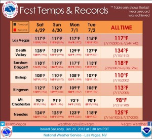
Now for a REAL heatwave, check this out from the Las Vegas NWS office:

vegas

Chief Meteorologist Mark Nelsen


First Heat Wave of 2013 On The Way

June 27, 2013

6:30am Thursday…

It looks very likely now that we’re headed into a stretch of hot weather to start July, I’ve got an update for you

The Basics:

  • Temps top out around 90, give or take a few degrees, Friday-Sunday in the western valleys, including Portland
  • Quite a bit warmer (hotter) Monday-Wednesday.  High temps somewhere between 95-105 degrees.  At this point the most likely scenario is hottest temps Tuesday with a high right around 100 degrees!
  • Humidity…rarely do we have humid conditions at the same time as hot weather; this will be one of those times.  We may see low temperatures close to 70 early next week, very unusual.

The Details:

I’m still at the weather conference in Nashville, thus the early start!  Models have become quite a bit more organized with the approaching hot ridge of high pressure for early next week.  Upper level ridge seems to be strongest and almost right over us Monday-Wednesday.  Here is the 500mb forecast for Tuesday morning from the ECMWF.

ecmwf_500_tue

Look at those heights!  A 597dm closed high over Eastern Oregon?  I don’t remember the last time I’ve seen heights that high so close to us.

This is an unusual setup that I haven’t seen in many years;  a highly amplified ridge with the sharp and deep upper low well offshore.  Usually we just have a bulky-looking ridge and the appearance is a bit flatter.  The GFS continues to produce much warmer 850mb temps (in some runs) than the ECMWF.  It also has the ridge slightly farther west (right on top of us), giving stronger offshore flow Tuesday-Wednesday.  It would say we’re up around Portland’s record high (107) during that time.  Considering it’s past performance, I’m ignoring it for now.  The ECMWF tops out those temps somewhere just under +25.  With flat or weak offshore flow Tuesday, I could see a high temp at PDX very close to or at 100 degrees.

You can see the difference in the two ensemble charts, the 00z ECMWF and 06z GFS:

tseries_850t_000-360_Portland

tseries_850t_000-384_Portland

Let’s talk humidity…it looks rough this time around!  We have two things going on.  First, plenty of moisture is just sitting over the Pacific Northwest from the recent rainfall, not necessarily just in the ground, but the airmass is very moist.  We’ve got dewpoints around 60 this morning.  Then a capping ridge of high pressure settles overhead without a period of drying north or northeast wind.  AND, areas to our north and east have been wet too.  Models show the humidity hanging around.  This means warmer than normal nights ahead and humid days.  If we get up around 95-100, we could easily have low temps around 70 degrees!

Get ready to hit the water, stay in air-conditioned places, or just plain sweat a lot over the next week!  The bonus is this kind of weather produces wonderful  evening and early morning weather, you’ll step outside and feel warm at sunrise…how “strange” is that?

Chief Meteorologist Mark Nelsen


Weather Conference In Nashville

June 25, 2013

I’m in Nashville these next 4 days (through Friday) at the American Meteorological Society annual Broadcaster’s Conference.  Today was a long day with a 3:30am wakeup call to heard to the airport after going to bed around 1am…Whew!

I’ve been blessed with a great job that has allowed me to do many things I wouldn’t have done otherwise, like attend these yearly conferences in a different city each time.  Last year was Boston, this year Nashville, rumor says Lake Tahoe next year.  Anyway, I try to do things and/or eat things that I wouldn’t normally experience in Portland.  So this evening my wife and I went to Caney Fork restaurant, near the Grand Old Opry.

photo (1)

First time I’ve ever eaten those fried green tomatoes in the pic.  Then I had catfish, hush puppies, and some sort of fried cornbread with powdered sugar on it.  All finished off with a piece of key lime pie.  I think I’ve now covered the basics of southern food; it seems to involve a lot of frying?  That was the one common theme I found.  The weather here is sweaty…high temp around 90 under hazy sun and a dewpoint around 70.

Speaking of warm weather, our warmup is still on the way in the Pacific Northwest.  The 12z GFS and ECMWF both pushed the upper level ridge directly over us Monday-Wednesday next week.  The 12z run of the GFS was the hottest I’ve seen in my entire career here.  The ECMWF was a bit more reasonable.  I noticed there is still a large amount of spread in solutions for early next week, so we may have just some normal hot weather (88-95), or we may get some sort of temperature spike up around 100.  The jury is definitely still out.  Here are the ensemble charts from the 18z GFS and 12z ECMWF:

tseries_850t_000-360_Portland

tseries_850t_000-384_Portland

Either way, our warmest and driest stretch of weather so far this season is on the way starting Friday.

Chief Meteorologist Mark Nelsen


Our First Heatwave? Possible Early Next Week

June 24, 2013

Heat Wave

June has been about as “normal” as it gets.  Temperatures here in Portland are running just slightly warmer and slightly drier than average.  We have two more cloudy and cool days ahead with showers at times; we could still end up above average for the month I suppose.

Beyond Wednesday?  Models have been advertising (for many days) strong upper-level high pressure developing over the Western USA.

Here are the key points:

  • The end of this week MAY be the “turning of the summer switch”.  We often start our real summer (abundant sunshine and dry weather) suddenly.  Not always, but more often than not it happens that way.  That may be about to happen.
  • 80+ temps arrive Friday and continue through at least the middle of next week…high confidence in this.
  • 90+ temps are possible Monday-Wednesday of next week…somewhat good confidence with this.
  • Near or above 100 degrees?  It’s looking likely most areas east of the Cascades below 2,000′ this weekend through early next week.  Some models are showing it nearly that hot here in the western Valleys the middle of next week too, very low confidence on this for now.


Here is the 12z ECMWF and 00z GFS 500mb chart for next Tuesday morning.  That is a hot ridge!

ecmwf_tues

gfs_tues

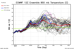
Of course there have been variations on the strength of the ridge and location.  The closer to us it ends up the warmer we get.   The 12z ECMWF above was particularly hot with 850 mb temps around +27 for the 2nd of July (next Tuesday).  If so, the weak offshore flow shown (under 595+ heights!) could easily put us over 100 degrees.  Luckily the ensemble chart tseries_850t_000-360_Portland

shows it was at the high-end, with the average more like the 12z GFS’s +22-23.  That’s still would put us well into the 90s Tuesday/Wednesday next week.  Here is the new 00z GFS ensemble chart:

tseries_850t_000-384_Portland

A little warmer than earlier runs, but the hot operational model is still warmer than its ensemble members.  Quite a bit of uncertainty on how far west the upper-level ridge builds.

One thing sticks out on all the model runs…we are headed into a warmer and most likely dry weather pattern as June ends and July begins.

Chief Meteorologist Mark Nelsen


ECMWF Monthly Maps

June 24, 2013

Last night’s run of the ECWMF out to one month…looks real hot next week and then above average beyond that.  This weekend MIGHT be the start of Pacific Northwest summer.

500za_week1_bg_NA

500za_week2_bg_NA

500za_week3_bg_NA

500za_week4_bg_NA


Family Vacation Wrap: 1600 miles in 8 days

June 21, 2013

Remember last year’s crazy driving vacation I took in June with the family? 3000 miles in a little over a week.

I decided to notch it down a bit this year; about half that mileage (1,600 mi) in 8 days.  This time we spent less time on the road, but still saw lots of cool new places and I even have a few tips for you.

DAY1:  Load up the 4Runner and trailer and push out! IMG_0311[1]  Drove from Corbett to Steamboat Rock State Park in north-central Washington.  A good 5-6 hour drive included a great food stop at a Greek monastery near Satus Pass.  Yummy homemade baklava and lots of other foods too.  I had never stopped in.  Then on to Yakima, Ellensburg, and my first time crossing the Columbia River at Vantage on I-90.  This area looks like The Dalles and we climbed up to a bunch of cool horse sculptures on the hill above the freeway, every single one of them vandalized by graffiti…nice. horses

DAY2:  Climb about 800′ up Steamboat Rock, which is surrounded by Banks Lake.

No rattlesnakes, but quite a view!

bankslake

The view in the picture is from the top, looking down at the campground.   By the way, here’s tidbit #1…GO CAMPING WHEN MOST KIDS ARE STILL IN SCHOOL IF YOU CAN.  I bet out of 20 sites in our loop, only 3-4 were being used on a Sunday night.  That’s the lake created by pumping out water from Grand Coulee Dam and into the Columbia Basin Reclamation Project.  This is just a few miles from Grand Coulee Dam itself.  I think everyone should visit this massive dam once in their life.  And ONCE is enough too.  We feel like we’ve “seen it and done it” now.  The tour of the dam takes about 45 minutes, and you’re followed by a well-armed security guard.  In fact we were warned that they get real cranky if you take their picture, so I didn’t.  This is what it looks like from the top of the dam looking down on the spillway, which was mostly closed. IMG_0296[1]Doesn’t seem THAT far, but it’s 350’+ down to the water…similar to one of Portland’s tallest buildings!

We went to the nightly laser show, which projects lasers across the face of the dam, kind of cool.  But I thought the best part was the opening of the spillway just before the show.  It’s very dim, but suddenly you see a wall of white descending the face of the dam.  It appears to be slow-motion, but you can hear the roar of the water as it takes a good 5-10 seconds to make it to the bottom, that’s how high it is.

DAY3:  Drive to Athol, Idaho and go to Silverwood Theme Park

IMG_0299[1]

I was pleasantly surprised by this place, and let me point out that no one gave me free tickets so it’s a totally unbiased review.  If you live in the Pacific Northwest and have kids I think you should visit this place once, or even once a year.  It’s a smaller version of Knotts Berry Farm.  Clean, lots of good junk food, a few scary roller coasters, a bunch of other carnival rides mixed in with wide paths and big shady trees…plus a real nice waterpark…all for $37 a day.  And if you purchase two days worth of tickets (as I did at a large boxy store with lots of toilet paper), you can return the unused tickets for a refund.  That was quite a deal because of Tips #2 and #3:  SILVERWOOD THEME PARK WAS A GREAT PLACE TO TAKE YOUR KIDS TO, and, YOU CAN DO THIS PARK IN ONE DAY, INCLUDING THE WATERPARK PORTION.  No need to spend two days on this one, although if you are totally bored it wouldn’t hurt I suppose.  The best part of this place?  Hardly any lines!  On one roller coaster we waited about 5 minutes, but every other ride and waterslide was line-free.  Apparently local Idaho schools were out, but Spokane was still in session.  That probably helped.  I WOULD NOT VISIT THIS PARK ON A WEEKEND IN SUMMER.  I have a feeling the lines would be awful since there are not that many rides and I saw comments to that effect on Tripadvisor.  So go in late May, early June, or in September.

DAY 4:  Camping at Farragut State Park

This was a wonderful and huge state park just a few miles from Silverwood.  Thousands of acres because it used to be a big naval training facility during WWII.  In fact there are tons of bike/hiking trails all over the place with old roads/paths that wander all over the place.  Lake Pend Oreille half surrounds the park and it’s COLD this time of year, I’d guess 55-60 degrees at best.  Other than that, I highly recommend this park for camping if you’re in the area.

DAY 5:  Drive to Two Medicine Lake in eastern Glacier Park

Lots of driving this day, but I’ve never been to Sandpoint or Bonner’s Ferry, ID.  Or to Libby or Kalispell, MT  All beautiful places, although with those first two I have a feeling there is more to those areas culturally than the beautiful view?  Two Medicine Lake camping was cool at 5,000′  The best weather was the afternoon we arrived, partly cloudy and 55 degrees.  Smallish NP campground with no electricity/water hookups.  But what a view!  Mountains all around and a chilly (40) lake nearby.

DAY 6:  Visit the eastern half of Glacier National Park

Mostly cloudy and off/on light showers and 45-50 degrees, think  “an average February day” in Portland.  We drove up to Swiftcurrent Hotel in the Many Glacier area…very cool old hotel.  Here are a few pics:

IMG_0314[1]

IMG_0315[1]

Nice lobby eh?  Not an outdoor day so a 15 minute hike up to a waterfall was all the hiking action we got.  That night the wind increased and the rain picked up…not exactly a “summer vacation” I was looking for.  By 11am the next day it was 43 degrees with ice pellets mixed in the showers at times.  That was enough, we decided to come back when the weather is warmer…like August or September.  My wife and I had been to Glacier once before in September and it was great.  This leads to tip #4:  DON’T VISIT GLACIER PARK IN JUNE EXPECTING WARM WEATHER AND LOTS OF HIKING.  Many trails are still snowed in or muddy.  Of course I knew that, but wanted to vacation in June anyway.  Once again, very light usage of campground and visitor facilities in the park since it was early in the season too.

DAY 7:  Drive to Browning, Missoula, Lolo Pass and camp along Lochsa River

I made the (nutty) choice to drive down the east side of the divide…beautiful wide open plains and hills, and lots of crosswind the first 90 miles too.  Not real fun hauling a trailer through that.  At one point I noticed a sign that said ROGERS PASS and realized there was some sort of weather story with this place

IMG_0318[1]

Sure enough, this is the place!…the coldest temperature ever recorded in the continental USA occurred here in 1954…70 degrees below zero!

The day ended crossing Lolo Pass and descending into the longest curving drive I’ve ever done.  In fact the sign was disturbing:

Winding Road Sign, Lolo Pass, Idaho

I already knew this was a longer and very winding route back to Washington, but I’ve done I-90 from Missoula to Spokane several times and it has now bored me.  This is what it looks like for the next 3+ hours on Highway 12 from Lolo Pass to near Kooskia:

IMG_0322[1]

It IS beautiful, and we camped halfway through which broke it up a bit.  But in reality it was 170 miles once you include the following 70 slightly less curvy section from Kooskia to Lewiston.  I don’t need to do that road again anytime soon. Tip #5:  US 12 FROM MISSOULA TO PORTLAND IS NOT A SHORTCUT EVEN THOUGH IT ALMOST LOOKS LIKE IT ON THE MAP.  Yes, I already knew that, but wanted to see what it was like anyway.

DAY 8:  Drive home

A long day of driving again.  I did get to see part of the bike ride I’ll be going on in early August.  Lewiston ID to Dayton, WA is day #4 of a cycling tour.  That first hill out of Lewiston will be brutal, praying that we aren’t in a heatwave weather pattern or I’m a dead man.  Nice driving though on this day.  We hit civilization in Walla Walla when the kids begged to go to Starbucks and get some sort of fatty drink.  Then it was 3.5 hours home!

And that was the trip…I’m thinking maybe next June we’ll do the desert southwest…I need more sun that time of year.

Chief Meteorologist Mark Nelsen


Another Funnel Cloud

June 19, 2013

Okay, I know this borders on the “not real interesting and very hard to even see” category, but a barely discernible pic of a funnel cloud just west of the Portland Airport this afternoon.  Brian Burk of the Port of Portland says he observed it (and took pics) for 5-10 minutes before it dissipated.  This happened around 2:45pm today:

photo_funnel2

photo_funnel1

Kelsey Gile took what appears to be a picture of the same funnel cloud from the Portland Air Base:

KELSEY GILE FUNNEL CLOUD. JPG

Very hard to see, so maybe you’ll like this one of a waterspout coming onshore in Louisiana instead?

photo_funnel3

Thanks to the New Orleans NWS office for that one!

I’ve got some maps!  Last night’s run of the ECMWF out to one month.  Each map is the weekly average 500mb heights:

500za_week1_bg_NA

500za_week2_bg_NA

500za_week3_bg_NA

500za_week4_bg_NA

Troughing just offshore and very wet westerly flow Sunday through Wednesday next week, then ridging much closer to us by around Day 10.