Winter Is Over In the Lowlands; What Does That Mean?

February 27, 2018

Winter 2017-2018 is done; time to stick a fork in it!

What kind of a statement is that?  It means I’m quite confident we’re done with most of our typical winter weather events.  But not all!

First, a quick look at “winter” shows we have been a bit warmer and drier than normal; definitely not a typical La Niña winter.  Only in the 2nd half of February did things finally kick into gear.  Take a look at the temperature anomaly the past 90 days in the West

Precipitation anomaly since late November shows most of the West has seen a very dry winter:


Looking at the maps ahead, I don’t see an outbreak of cold arctic air.  For that matter I don’t see unusually chilly air for this time of year.  That plus the calendar turning to March tells me we’re done with most of these weather events for the season

Sure, we can still get a chilly east wind, but in March we don’t get long periods of cold easterly wind.  As mentioned I don’t see a setup for an all-day type snow event that would keep roads frozen/snowy.  It’s too late to get a damaging arctic blast; and nothing is seen on our models.  I’ve never seen widespread flooding in March, although I remember the flooding around Salem a few years ago in March.  Again, that was localized.

What actions can YOU take at this point?

There you go.  Basically it’s time to “de-winterize”.  Now if you live in the foothills like me, I’d leave the snow tires on a bit longer to see what’s ahead next week.  Same thing if you regularly go up/over the Cascades.

What might we still see in March?

Of course in any year we can still get a brief wet morning snowfall even at the lowest elevations in March, but in these La Niña winter/springs the chance of that happening is higher.  Remember March 2012?  That’s an extreme version of what can happen, but we saw significant sticking snow overnight hours several times, including at the coastline.  In fact even later this week (mainly Friday) we could see brief snowfall in the overnight/morning hours.  That’s assuming we have enough moisture when it’s cold enough.

Obviously we still get freezes in March, but they become milder and a temperature below 25 is unlikely for most of us.  And we can sure get a windstorm in March!  Remember last April?  Gusts 45-60 mph in the metro area in the first week of the month.  That IS the latest I’ve seen a windstorm; it’s more common in March.

Chief Meteorologist Mark Nelsen


Snow Showers Tonight; White Dusting For Some Monday AM

February 25, 2018

8pm Sunday

Earlier in the winter this would have been a BIG deal.  But we just went through a week of seeing snow at times, so now a forecasting of a “possible dusting” in the lowlands and a half inch up at 1,000′ doesn’t seem quite so dramatic does it?

A cold front passed through the area this afternoon and behind that is a very chilly airmass.  In fact by daybreak the sticking snow level should be just about on the valley floor (sea level).  The mixing south wind will be gone by that time too.  But the limiting factor for snow tonight is the showers drying up later tonight just when it’s finally cold enough to stick at the lowest elevations.  Notice it’s too warm for most of us at 8pm.

web_metrotemps

Because of this I think it’ll be tough to get more than 1/2″ anywhere in the metro area below 1,000′ or so.

Snow Tonight Forecast 1

So ANY OF US IN THE LOWEST ELEVATIONS COULD WAKE UP TO A DUSTING OF SNOW ON THE GROUNDI don’t expect the snow itself to be a significant issue for the morning commute.

As mentioned in the graphic above, a bigger issue may be spots of ice on some roads by sunrise.  We’ll have a few wet areas, partial clearing overhead, and a calm wind by morning.  That combo will likely allow temperatures in some areas to fall to/below freezing.  I think that’s most likely central/west metro area where we get more clearing.

The rest of Monday will be uneventful with partly cloudy skies, a few sprinkles/flurries, and highs well into the 40s.

Next chance for lower elevation snow will likely be late week as cold showers return.  As of now there is no sign of a widespread snow event this week…as the calendar turns to March.

Chief Meteorologist Mark Nelsen


Winter Snow Stats

February 24, 2018

10am Saturday

Temperatures rose into the upper 30s last night with the southerly wind as expected.  It was nice that the warming shown overhead by models appeared too.  Snow showers changed to a rain/snow mix or just rain at the lowest elevations during the late night hours in the metro area.

So we didn’t have sticking snow yesterday or last night.  But was that it for the winter?  History tells us that’s most likely.  But with cold upper-level troughs still swinging through for another week we may somehow eek out another 1/2″ (or less).  We’ll see.

It’s snowing heavily in the Cascades and that continues through the weekend.  Note 2 to 3 feet forecast through early Tuesday

or_snow72.72.0000

Here are the winter stats so far:

  1. We have had FOUR official snowfalls.  That’s four with measurable snow at the Portland National Weather Service Office in Parkrose.
  2. February 2018 is the snowiest February since 1990.  It doesn’t take much, February snow isn’t very common.  Seems like we only get February snow 1 out of 3 years.
  3. We have had TWO freezing rain events, although one was just barely measurable and isolated to right along the Columbia River (Dec. 26).  Plus we’ll all remember that as one.
  4. Peak wind gust?  East at 41 mph…twice.  December 6th and January 15th.  Wind has been unusually light this year in the city; a real lack of south wind events.  We only had the strong east wind event in early/mid December; that’s it.

Winter Snow_Ice Totals So Far

Chief Meteorologist Mark Nelsen


Snow Tonight? No, Unlikely In Lowlands

February 23, 2018

10am Friday

Last night was COLD!  Lots of mid/upper teens in the coldest part of the metro area.  I had a 15 at my house which was the coldest of the winter.  But it’s late February and daytime temps rise quickly.  Most of us are around 32-35 degrees at 11am.  We’re headed for high temps around 40 by 4pm.

There is talk of another snow evening this evening and overnight in the lowest elevations.  But as mentioned in my previous post, IT’S A NON-EVENT THIS EVENING AND TONIGHT

KEY POINTS

  1. THE THREAT FOR SNOW STICKING ON ROADS HAS PASSED FOR THIS EVENT, THROUGH AT LEAST SUNDAY EVENING
  2. Temperatures will likely stay ABOVE FREEZING from now through Sunday evening for almost all the metro area and lowland locations
  3. Light snow showers or rain/snow mix WILL develop this evening for most of us, then quickly change to rain showers between 7-10pm below 1,500′
  4. Near/above 1,000′ there could be a brief accumulation on non-road surfaces in the metro area between 4-7pm, that’s a big IF moisture arrives as anything other than light flurries.  Best spot for an inch or so (before warming in the late evening) might be north Clark county & Columbia county hills well above 500′.
  5. By 10pm, snow will only be sticking near/above 2,000′.  Late tonight the snow level drops back down to around 1,500′ after a cold front passes, but that’s it.


TO SUMMARIZE  You can go about your normal lives now through the weekend; it’s unlikely weather would affect your plans…except for rain of course


Why don’t I think we’ll see sticking snow this evening?  It’s because this IS the setup that DOESN’T give us snow.  This isn’t a “BC Slider”.  It’s a weather system sliding by to the north with a cold front passing through in the middle of the night.

NO COLD EAST WIND OUT OF THE GORGE

We don’t have any supply of cold & dry air to keep things cool like with our typical snowstorms.  In fact it’ll be a breezy west wind by morning out there.

WARMING ATMOSPHERE OVERHEAD WITH SOUTHERLY FLOW

Check out the WRF-GFS at 4pm.  That’s cold enough to bring snow (at least in the air) down to sea level

The temperature contour is up around 2,500′.  Note the 2-3 millibars southerly flow from Eugene to Portland.   Then 10pm…

Wow, that is a classic southerly warm-up signature.  Above freezing west of the Cascades up to over the 2,000′ elevation!  About 6 millibars surface pressure gradient from Eugene to Olympia.  This will give us a south wind in the valley/metro area 10-20 mph with gusts to 30!  It doesn’t snow here in that setup.  I’ve also checked cross-sections and soundings from models.  All show the same thing.  I will be home here this evening at 1,000′ in the Cascade Foothills.  I’d be surprised if I get more than a dusting even up here.

NO MODEL GIVES US SNOW

Here’s the WRF and ECMWF…not even a hint of sticking snow at lowest elevations


I didn’t mention surface temperatures, which will be well above freezing through the evening for all lowland locations.  We should top out around 38-40 this evening, then temperatures hold steady in the mid-upper 30s through the night.  We may actually pop up to 40 or beyond after 10pm.

I’ll be off until Sunday, time for a weekend!

Chief Meteorologist Mark Nelsen


Snow Storm #3 Delivers; A Cold Night Ahead

February 22, 2018

10am Thursday

Around midnight the central/west side of Portland was nailed by very heavy snowfall.  While driving over the Marquam Bridge I couldn’t see anything except the edges…like being out in space.  Pancake-size flakes were instantly smothering everything in white; quite a neat drive and my snowiest since a night in January 2012 (I was inside for last January’s big snow).

The storm sure delivered for most of us and 1-3″ snow forecast was perfect.  The far eastside got less than 1″ and I see some complaining that another spot or two had an inch or less.   Salem didn’t quite get an inch, but Eugene was nailed…lots of 1-4″ totals down there.  And I see Astoria, Tillamook, & Seaside all had 1″.

Almost everyone got SOMETHING which means this storm gave us the best coverage region-wide of all three.  

The official total at the NWS office was 2.1″   

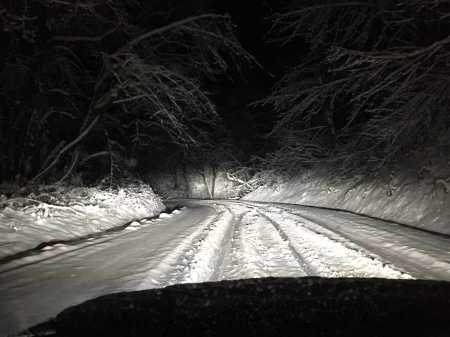
It made for a nice pic from Clifford Paguio this morning:

paguio

One thing that has much different with this storm?  Temperatures remained right around freezing through the event.  That means main roads only briefly saw a big dumping of snow, then it either melted or was plowed off.  So I see some schools are in session today.

WHAT’S AHEAD?

The big news…WE ARE DONE WITH LOW ELEVATION SNOW THE NEXT FEW DAYS

Forecasting is much easier now.

TONIGHT

  •  Clear skies tonight + dry air + cold airmass + snow on the ground = COLD!
  • Lows could easily dip into the teens in some outlying areas with snow on the ground, we may drop below our 23 so far this season at PDX too if mixing east wind stays away.

TOMORROW & THE WEEKEND

  1. Skies cloud up tomorrow and precipitation arrives in the late afternoon or evening, temperatures will be above freezing at that time
  2. A strong onshore flow and warming atmosphere means at BEST we’ll have snowflakes mixed in, but then the sticking snow level jumps up to at least 1,500′ in most of NW Oregon through Friday night and into Saturday morning
  3. I DON’T EXPECT ANY MORE SNOW BELOW 1,000′ IN THE METRO AREA THROUGH THE WEEKEND
  4. A COUPLE INCHES ARE POSSIBLE ABOVE 1,000′ TOMORROW EVENING, especially in Columbia and Clark Counties where the cool air may linger a bit longer.

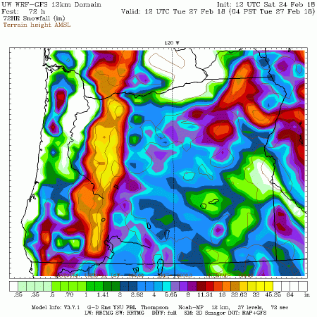
But the big story this weekend is the dumping we’re going to see above 2,000′ in the Cascades.  Yep, that says 2-3 feet of snow by Sunday afternoon on Mt. Hood.  Notice the NE Oregon mountains get nailed too.  Winter is here to stay for a while, although Spring in February was nice too.

or_snow72.84.0000


Here are some other totals from last night.  Sorry about the formatting but free is a good price for this info from our friends at the NWS Portland.

Public Information Statement
National Weather Service Portland OR
910 AM PST Thu Feb 22 2018

…Updated Snowfall Reports…

Location Amount Time/Date Elevation (ft.)

…South Washington Cascades…
June Lake Snotel 1.0 in 1200 AM 02/22 3440
Spencer Meadow Snotel 1.0 in 1100 PM 02/21 3400
Swift Creek Snotel 1.0 in 0700 AM 02/22 4440
Surprise Lakes Snotel 1.0 in 1200 AM 02/22 4290
Lone Pine Snotel 1.0 in 1200 AM 02/22 3930

…Northern Oregon Cascades…
Tombstone Summit 3.0 in 0600 AM 02/22 3520
Bear Grass Snotel 3.0 in 1200 AM 02/22 4720
Clackamas Lake Snotel 1.0 in 0700 AM 02/22 3400
Peavine Ridge Snotel 1.0 in 1200 AM 02/22 3420
Marion Forks Snotel 1.0 in 0600 AM 02/22 2590
Mt. Hood Test Site 1.0 in 1200 AM 02/22 5370
Clackamas Lake Snotel 1.0 in 1100 PM 02/21 3400

…Lower Columbia…
Saint Helens 2.5 in 1209 AM 02/22

…Lower Columbia and I – 5 Corridor in Cowlitz County…
Woodland 2.3 in 1126 PM 02/21
Kalama 2.0 in 1200 AM 02/22
Kelso 2.0 in 1200 AM 02/22

…Greater Vancouver Area…
Battle Ground 3.5 in 1222 AM 02/22
Battle Ground 2.5 in 1144 PM 02/21
1 ESE Felida 2.0 in 1151 PM 02/21
Battle Ground 3.7 in 1230 AM 02/22
Vancouver Cascade Park 2.0 in 0600 AM 02/22 310
Vancouver 2.0 in 0600 AM 02/22 307
LaCenter 4.0 in 0600 AM 02/22
LaCenter 3.5 in 0100 AM 02/22

…Greater Portland Metro Area…
Milwaukie 4.0 in 0600 AM 02/22
1 NE Cedar Hills 3.0 in 1225 AM 02/22
Hillsboro 2.5 in 1142 PM 02/21
3 WNW Rockcreek 2.0 in 1156 PM 02/21
Beaverton 1.0 in 1118 PM 02/21
Council Crest 3.7 in 0100 AM 02/22 1000
Bonny Slope 3.7 in 0300 AM 02/22 500
West Linn 3.0 in 0200 AM 02/22 700
Cedar Mill 3.0 in 1230 AM 02/22
Oak Grove 3.0 in 0600 AM 02/22
Hillsboro 3.0 in 1200 AM 02/22
Banks 3.0 in 1200 AM 02/22
Oregon City 2.5 in 0100 AM 02/22
Oregon City 2.0 in 0530 AM 02/22 448
Happy Valley 2.5 in 0200 AM 02/22
Scappoose 2.4 in 1200 AM 02/22
NWS Office Parkrose 2.1 in 0100 AM 02/22
NW Portland 2.0 in 0600 AM 02/22 700
Gresham 2.0 in 0200 AM 02/22
Canby 2.0 in 0100 AM 02/22
Inner NE Portland 2.0 in 1200 AM 02/22
Portland Downtown (KGW) 1.8 in 0100 AM 02/22
Troutdale 1.5 in 0100 AM 02/22
Sherwood 1.5 in 0700 AM 02/22 200
West Linn 1.5 in 0100 AM 02/22
Wilsonville 1.0 in 0100 AM 02/22

…Coast Range of Northwest Oregon…
Buxton 4.5 in 1127 PM 02/21
Manning 3.0 in 1108 PM 02/21
Buxton 2.0 in 0957 PM 02/21
Saddle Mountain Snotel 2.0 in 1200 AM 02/22 3110

…Central Willamette Valley…
Newberg 3.0 in 0200 AM 02/22 500
Dallas 1.8 in 1109 PM 02/21
South Salem 1.0 in 1100 PM 02/21
Salem 0.8 in 1200 AM 02/22
Molalla 1.0 in 0845 AM 02/22 1000

…South Willamette Valley…
East Springfield 4.0 in 0800 AM 02/22
3N Cottage Grove 3.25 in 0700 AM 02/22
Brownsville 3.0 in 0700 AM 02/22 800
Pleasant Hill 3.0 in 0700 AM 02/22
Eugene 3.0 in 0600 AM 02/22 420
Creswell 2.5 in 0600 AM 02/22
Lacomb 2.0 in 1200 AM 02/22
Lorane 2.0 in 0600 AM 02/22
Eugene Airport 2.0 in 0530 AM 02/22
Springfield 2.0 in 0600 AM 02/22
Springfield 1.0 in 1200 AM 02/22
Albany 0.8 in 0600 AM 02/22 220
Eugene 0.7 in 1200 AM 02/22

…Cascades in Lane County…
Holland Meadows Snotel 5.0 in 0700 AM 02/22 4900
Mckenzie Pass Snotel 4.0 in 1200 AM 02/22 4770
Holland Meadows Snotel 1.0 in 1100 PM 02/21 4900
Roaring River Snotel 1.0 in 0700 AM 02/22 4950

…Coast…
Astoria 1.0 in 1100 PM 02/21
Bay City 1.0 in 1100 PM 02/21
Seaside 1.0 in 1100 PM 02/21
Tillamook 1.0 in 1100 PM 02/21


A Snowy Night Ahead

February 21, 2018

6pm Wednesday

Here we go again!

“Snow v3.0” is about to arrive.   This system is very similar to yesterday’s where a surface low pressure system slides south through western Canada, than slides south along the Washington/Oregon coastline.  This one should move right onto the Oregon coast and slide into SW Oregon.  Anywhere north and east of the low pressure center has a decent chance of sticking snow during the night.  That means that this time those of you in the central/south Willamette Valley may FINALLY see a snowfall.  Remember that Salem/Albany still haven’t seen measurable snow so far this winter.  You can see the movement of the low in the slideshow:

This slideshow requires JavaScript.


HIGHLIGHTS

  • Light snow develops the next few hours across NW Oregon, spreading east and south
  • Expect 1-3″ almost all inland locations from SW Washington down into at least the central Willamette Valley
  • Trace-2″ is possible along the beaches themselves
  • ROADS WILL BE SNOWY FOR THE THURSDAY AM COMMUTE
  • PARTLY CLOUDY THURSDAY = NICE MELTING AGAIN IN THE AFTERNOON, LIKE TODAY

One weak band of snow flurries just passed over the metro area and now we see deeper moisture/snow moving onto the north Oregon coastline.  By 10pm, snow should be falling along the north/central coastline and into the Coast Range.  In fact by 10pm snow may have begun in the metro area too.  Recall yesterday it showed up 8 hours ahead of schedule!

Temperatures are in the mid 30s at this hour, but more important is the dewpoint.  We’re in the mid-upper 20s which means falling snow will evaporate into the “dry” air, cooling the airmass.  The result is that we’ll have no problem getting snow to stick anywhere north of that low pressure center.  In the southern Willamette Valley there may be just enough southerly breeze (like with last night’s system) to keep the sticking snow level off the valley floor.  We’ll see how that plays out.  Luckily models are in slightly better agreement with snow accumulation up north.  Here’s the GEM  snow contour, with the snow forecast from each model on the table.  This is the main reason we’re forecasting 1-3″.

Now our 00z RPM just came in with better accumulation in the metro area:


So we’ll see how this plays out, at least it’s happening when most of us will be asleep and hardly anyone will be on the roads.  It’s also kind of nice that we’ll be able to drive around like normal once again tomorrow afternoon.

Tomorrow night, assuming skies clear out as expected, we’ll likely have another very cold night.  This morning at the last minute it cleared out at PDX, allowing the temperature to plummet to 23.  We have the same setup for Friday morning.  Maybe a late season 19?

Chief Meteorologist Mark Nelsen


Round 3: Snow In Valley Tonight

February 21, 2018

10:30am Wednesday

That was a fun drive home last night.  Freeways were mainly wet/slushy until I made it around the “Gateway Turn”.  I-84 suddenly turned icy in the usual spot past the I-205 split.  Colder/drier air from the Gorge had already frozen the freeway out there.  Then the last mile to my home wasn’t plowed.  5″ new on the road…I’m glad I didn’t take the snow tires off when it was 60 degrees!

download

Just a quick post to let you know what’s up for tonight and tomorrow AM.

All models show another “BC Slider” (or is it “Yukon Slider”?) coming down along the Oregon Coast tonight.  Timing is perfect if you want more snow, the bulk of the precipitation falls in the middle of the night.  Check out the trusty ECMWF model, showing 1-3″ in most of the Willamette Valley and metro area tonight.

ecmwf

Several other models show heavier totals around Salem, I’ll look at it in more detail this afternoon, but here’s the main message:

  • EXPECT ONE MORE ROUND OF SNOW…LIKELY 1-3″, IN MUCH OF THE LOWLANDS TONIGHT.
  • THURSDAY MORNING’S COMMUTE WILL LIKELY BE SNOWY, WITH SNOW/SLUSH ON MANY ROADS

This appears to be the last snow event for now since Friday night’s wetter system has a strong southerly, warming, onshore wind arriving at the same time as the precipitation.

I’m headed outside to enjoy the sun, and play with the snowblower I thought I wouldn’t use this winter…8″ snow on the ground here.

download (1)

Chief Meteorologist Mark Nelsen