Warmest Day Of December & Low Mountain Snowpack

December 29, 2017

7pm Friday

What a warm day!  Temperatures reached well into the 50s west of the Cascades with even some lower 60s showing up south of Eugene.  Central Oregon got into the warm weather act with low 60s in Redmond and Bend.

Todays Observed Highs OrWa 2017

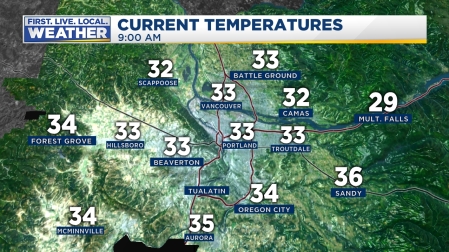
Today we have been in the warm sector between a warm front that passed overhead last night and an approaching cold front.  The gusty southerly wind brought in the warm air.  The wind has remained light easterly in the Gorge, keeping temperatures in the 30s there.  This warming winter wind after a cold spell actually does have a name; although it’s rarely used anymore.  It’s the original “Chinook Wind” before that name was more commonly used to refer to westerly warming wind off the east slopes of the Rockies.  We should use it more often just to annoy those folks in Denver.

At 7pm the cold front is moving into the western valleys of Oregon and Washington, evidenced by falling dewpoints and temperatures at Astoria.  A surface low pressure area is moving across NW Washington and will move into Eastern Washington the next few hours.  This reverses the pressure difference across the Cascades, leading to a gusty WEST wind through the Gorge.  The WRF-GFS forecasts 4-6 millibars by 10pm!  That means you’ll make a quick jump to 50-55 degrees in The Dalles sometime between 9-11pm.

Unfortunately for the mountains and ski areas, it has been pouring all day long.  The snow base dropped by about 10 inches at Timberline due to the warm rain.   Radar and models show this is not the type of system where we get lots of cold showers behind the front tonight.  In fact we only expect a dusting to 3″ at the ski areas by midday tomorrow.  The fresh snow just before and during Christmas was great; salvaging what could have been a really rough Christmas Break.  But all signs point to a continuing pattern of weak and warmer than normal systems for the next 7-10 days.  Take a look at the latest snowpack numbers…only about 50% of normal for the end of December:

Snowpack Oregon Plus Facts

Snowpack Oregon Plus Facts2

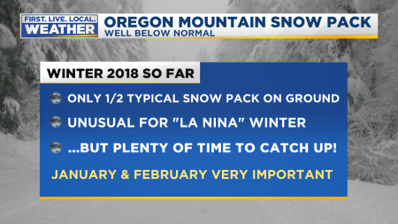
We’ve seen this in the past, but generally not in La Nina winters.  I’m not sure what’s going on this year since we keep seeing ridging popping up over or just west/northwest of us.  You may also notice the lack of stormy weather.  How often (since October) have we seen this gusty south wind and a strong frontal system?  Not much…this winter is reminding me of the La Nina of 2000-2001 which turned into quite a dud for the region.  That year we had one ice event in mid-December too which brought freezing rain to the metro area.  Other than that it was a mainly quiet winter.  We’ll see, there’s still a good 6 weeks in which we could get a widespread snow/ice event in the lowlands and of course we can get a wet morning snowfall all the way into March.  And this weekend should be just fine with much colder temps firming up the snowpack tonight

Snow Report

In the short-term, we have a nice weekend ahead with mainly dry weather.  Sunday and Monday we’re back into the chilly east wind pattern.  Your New Year’s Eve will be chilly and breezy (or very windy if you live in east metro) but dry and comfortably cool

New Years Eve Fcst

Chief Meteorologist Mark Nelsen


Cold Spell & Freezing Rain Threat Is Over

December 27, 2017

10am Wednesday

As expected there were no new areas of icing on metro roads this morning.

Icy roads in the hills and mainly east of I-205 of course stayed put and a new layer of ice showed up from showers/drizzle, but that was in the forecast too.  Temperatures have now risen to or above freezing just about everywhere in the metro area and will continue rising through the day (slowly).

web_metrotemps (1)

More important, all road pavement temperatures except right at Troutdale are above freezing too.

The Portland stats for our Christmas snow/ice episode:

Official Snow (measured at Portland NWS in Parkrose)  

  • 1.0″ – December 24th

Official Ice (freezing rain measured at PDX Airport by automated sensor)

  • .31″ – December 24/25th
  • .08″– December 26/27th


The easterly wind through the Gorge has died down to a slight breeze so we’re done with the “resupply” of cold air.

The ECMWF has hinted for a few runs that we get a southerly breeze coming up the Willamette Valley today.  Now the WRF-GFS and MM5-NAM show the same thing.  In fact the ECMWF has us jumping into the 40s this afternoon; warmer than our forecast.  I’m guessing this will probably happen except right along the Columbia River.

Enjoy the milder weather today; tomorrow late afternoon/evening we should see temperatures jump to around 50 or so on a stronger southerly breeze.

Chief Meteorologist Mark Nelsen


Spots of Ice Metro Area Wednesday AM

December 26, 2017

9:30pm Tuesday…

OVERNIGHT

This cold episode has just about played itself out in the metro area.  The cold air layer is quite thin, so I’m thinking it’s going to be tough to get precipitation in the form of snow as all models show warming above about 2,000′ during the night.  Most (light) showers should be in the form of sleet (ice pellets) or liquid rain.  So of course to get freezing rain you have to get surface temperatures below freezing.  Note the current temps:

2017 Current Temps PDX Metro Area Earth Scene

Thick cloud cover has moved in, stalling metro area temperatures right around the freezing mark.   We’re not going to see any significant additional drop.

The flow of cold/dry air out of the Gorge has weakened dramatically.  Only 3+ millibars PDX-DLS is not typical ice storm material for us.  It’s just a breeze from the east right now even in the usual windy spots; evidence the cold pool is shrinking and turning shallower eastside.

Dewpoints have also risen a bit, so if/when precipitation arrives, temperatures will only fall maybe 1-2 degrees with evaporative cooling.

That means almost none of us drop below 30 degrees.  Which leads me to believe that most roads which are thawed right now are unlikely to re-freeze tonight.  Freezing rain typically needs air temps down to 30 to get new ice on roads that aren’t already frozen.

SUMMARY

  1. It’s doubtful we see a widespread icing of already-thawed roads in the metro area
  2. There may be a few new spots of icing, but the main highways/freeways WEST of I-205 and south of Milwaukie/Happy Valley should be clear tomorrow morning.
  3. Frozen roads in the hills and east metro will remain that way through the morning commute.

We continue the slow thaw tomorrow with almost all roads in decent shape by late afternoon, still some ice east of I-205 though.

South wind arrives Thursday afternoon/night.  Until that time no dramatic warmup, just a slow thaw.  We should be around 50 by late Thursday evening.

Chief Meteorologist Mark Nelsen


S-L-O-W MELT CONTINUES, FLURRIES OR FREEZING RAIN SPOTS TONIGHT

December 26, 2017

2:30pm Tuesday

Temperatures warmed…slightly…today.  It appears the airport hit 34 or 35 degrees.  Snow & ice doesn’t melt fast, even with morning sunshine, at that temperature.  Cool air is still pouring out of the Gorge, although the wind is relatively light.  The airmass within the Gorge has modified a bit further, with Hood River now about 5 degrees warmer than before things got started Christmas Eve midday.

Rumors of more freezing rain, sleet, or snow abound; here’s the deal.

  1. IF this was a typical winter afternoon and the weather pattern was exactly the same but 40 degrees right now?  I’d forecast cloudy skies tonight with a few sprinkles or showers.  Then more widespread sprinkles or showers at times tomorrow.  There’s no big storm headed our way, just a few showers.
  2. But it isn’t a typical winter afternoon and temperatures will still be cold enough for either snow/liquid rain to stick or form a glaze on surfaces tonight IF PRECIPITATION ACTUALLY FALLS OUT OF THE SKY.  IT COULD REMAIN MAINLY OR ALL DRY.  I think it’s unlikely we get more than 1/2″ snow.  Just a dusting in many spots.
  3. Not all of the metro will see cold enough temps for frozen roads tomorrow morning.  Lots of cloud cover SHOULD keep some areas only right around freezing.

So here’s my forecast:

Mark Snow Metro Forecast

FOR THE AM COMMUTE

Mark Road Condition Forecast

  • I think there will be additional icy areas that were not there this evening, assuming showers do show up.  Expect lots of slippery areas in the West Hills and eastside where temperatures will be coldest.  We may not get a total freeze of roads westside, but ANYWHERE could see a dusting of snow or fresh ice.  With scattered showers it’s tough to know exactly where that happens.
  • Roads will improve a bit more tomorrow.  Today my drive on the freeways was just dry or wet in spots, no ice from Troutdale to Beaverton.  Actually out in Beaverton you wouldn’t even know there was ice/snow two days ago…almost nothing left except on barkdust/grass in spots.  But I know many areas eastside and in the hills still have ice on roads.  That should improve tomorrow.

By the way, Thursday and Friday we’ll be around 50 or above.   The cold weather is just about finished…More later.

Chief Meteorologist Mark Nelsen


Back to a White Christmas

December 24, 2017

7pm Christmas Eve

Merry Christmas from the FOX12 Weather Team!  Today has sure been a challenging day for us.

WHAT WORKED OUT RIGHT TODAY

  1. Cold air remained in place.  Temperatures stayed near/below freezing in most of the metro area as cold east wind kept coming out of the Gorge.
  2. 1st band of light precipitation came in as freezing rain/sleet/snow mix 9am-Noon.
  3. 2nd main band of precipitation arrived in mid/late afternoon as expected.
  4. West Hills and east metro roads remained frozen as expected.
  5. Typical west and south metro life resumed since roads turned mainly wet.  The shopping center near the station here on the westside was a zoo at 2pm.
  6. All roads central/eastside remain a frozen mess this evening as freezing rain has returned for many spots.  With the cold air we knew that would happen and I mentioned that this morning.

WHAT WENT WRONG (IN A GOOD WAY!)

  1. The 2nd band of precipitation was mainly snow instead of a mix.  That’s because  warming wasn’t as much as expected a few thousand feet up; the snowflakes didn’t melt into rain drops on the way down.  A trace to 2″ snow fell across most of the metro area (lightest west and heaviest east).
  2. I figured some snow would fall in north metro (Clark/Columbia counties), but not that much.  It was snowy all day up there with 2-4″ on the ground now.

Of course hardly anyone would complain about getting frozen precipitation in the form of snow instead of freezing rain, especially on Christmas.  As of 5pm the official snow total was 0.6″ in Portland, I’m guessing that will be higher when they measure later.

Latest temps show almost all the metro area is below freezing and it’ll stay that way tonight with no change in the low-level airmass.

2017 Current Temps PDX Metro Area Earth Scene

We’re into light off/on showers the rest of the night with a mix of freezing rain, snow, & sleet.  South of the Columbia River with thinner cold air above I think we’re mainly done with accumulating snow.  Once you get south of Wilsonville it’s a little too “warm” for anything frozen tonight.

MarkWarningsWinterWeather Polygons

North of the Columbia River more than likely it’ll remain as snow.

MarkWarningsWinterWeather Polygons2

The ice/snow that is on roads now isn’t going anywhere and will still be there when you wake up Christmas Morning.  With precipitation ending after sunrise, it should be a quiet weather day with temperatures gradually rising into the upper 30s.  That means a slow thaw with decent road conditions AFTER the noon hour.  Plan to visit friends during the afternoon/evening hours, not in the morning.

Chief Meteorologist Mark Nelsen


It’s Christmas Eve! Silver Christmas For Parts of Metro Area

December 24, 2017

8:30am Sunday

For the first time in about 20 years I’m sitting here on Christmas Eve figuring out how a “classic” snow/ice event will proceed for the Portland metro area.

Of course in 2008 we had all the snow on the ground and expected a little more the next day, that was easy.  You have to go all the way back to 1998 to find a couple of inches of morning snow Christmas Eve; then it melted by evening as the cold east wind died.  This time it appears the cold air is here to stay THROUGH TONIGHT.  That’s a problem for many of us in the metro area and Gorge.  It’s also a change from my post 24 hours ago.

RIGHT NOW

A band of light precipitation is moving through the North Willamette Valley and into the south metro area.  It appears to be mainly rain/freezing rain with some sleet (ice pellets) mixed in.

Temperatures are near/below freezing throughout the metro, Willamette Valley, and of course in the Gorge.  A layer of cold/dry air pouring out of the Gorge is about 2,000′ thick in the metro and thinner south of us in the valley.  It’s a few degrees colder than I was expecting.  Where it is above freezing (by 1-4 degrees), the air is dry enough that when moisture falls into it, temperatures fall (evaporative cooling).  This means ANYONE could get frozen precipitation of some sort the next few hours from Longview to Salem/Albany.  This part of the forecast hasn’t changed.  We thought there would be scattered icy areas if/when that first band of precip arrives.

THE MAIN MESSAGE

Models are bringing in this afternoon/evening’s system a bit farther south, prolonging the period that at least 1/2 of the metro area will get freezing rain (and icy roads) the next 24 hours.  It appears more of the metro area will see freezing rain than I was thinking 24 hours ago.

WESTERN VALLEYS FORECAST HIGHLIGHTS

  • Oregon Coast will be too warm for frozen precipitation, all clear out there
  • After patchy areas of freezing rain this morning, some weak daytime “heating” in much of the Willamette Valley south of a Newberg-Wilsonville-Sandy line will be enough to keep roads mainly clear through tonight; temps will hover just above freezing.  AFTER late morning, most of the Willamette Valley should be done with icy roads.
  • IN the metro area the cold temps mean precipitation with this first band could ice up roads anywhere before noon.  As we go through midday and early afternoon, main roads should be fine away from the Gorge as pavement temperatures stay above freezing.  Near the Gorge and in the West Hills icy areas will stick around all day.
  • After sunset and into this evening, more solid precipitation arrives.  It should be mainly freezing rain across the entire eastern half of the metro area north of Oregon City and in the West Hills.  Expect widespread icy roads for all these areas through the night and into Christmas Morning.  A Silver Christmas for many of us tomorrow morning.
  • West of the West Hills and Clark County there may be more snow mixed in with slightly deeper cold air.  Temperatures may go a few notches above freezing.  Ice on roads should more patchy in those areas.
  • Christmas Day temperatures will gradually go above freezing and ice even near the Gorge will melt off.  High temps reach into the upper 30s.

IN THE GORGE

  • Light snow arrives midday, then picks up a bit this evening and overnight.
  • Expect 2-4″ fresh snow central/east Gorge
  • West of Multnomah Falls, it’ll be more freezing rain & sleet than snow.  Expect glaze ice on roads around Cape Horn and Corbett/Bridal Veil areas as we go into the overnight hours
  • Not much melting Christmas Day since cold easterly wind will just weaken a bit.


There are 2 reasons the forecast has changed back to more ice the past 24 hours.  First is that the cold air pouring through the Gorge is a few degrees colder than expected.  That gives more of us an “opportunity” to enjoy frozen precipitation.  And second, sure enough the ECMWF model is looking like the smarter one, bringing in low pressure farther south.  Check out morning WRF-GFS low position at 10pm this evening:

There it is…right around Tillamook.  This is far enough south to keep the cold easterly wind going in the metro area through the night.  But it’s also just far enough north to push mild air over the top of the cold air, that mostly eliminates the snow chances keeping our precipitation in mainly a liquid form.  Of course that liquid can refreeze into sleet (ice pellets) or freeze on contact (freezing rain).  Notice there is no southerly wind in the metro area even by 7am Christmas morning; temps will rise a couple of degrees in the valley overnight, but we’ll stay frozen through the entire night in that easterly flow out of the Gorge in the entire eastern half metro area.

Be careful on the roads today and if you live on the east side of the metro area I’d plan to stay at home this evening through Christmas morning.

Chief Meteorologist Mark Nelsen


White Christmas Unlikely For Metro Area

December 23, 2017

9am Saturday

Some of us woke up to a little snow this morning!  Precipitation is dwindling to just about nothing now but as the first cold air poured through the Gorge that area has seen 1-5″ snowfall (as forecast) and even a dusting fell in Portland’s West Hills and far east metro area (Troutdale & Gresham).

Today will be a dry day with increasing sunbreaks & cool temps.  The cold easterly wind will pick up in the Gorge and central/east metro.  Gusts 30-40 mph are likely in the windy parts of the metro area and 60-70 mph in the Gorge by this evening/overnight.

Of course the big question is Sunday and Christmas

THE BIG PICTURE

  1. The chance for a metro area ice or snow storm has gone downhill since yesterday, models are pushing that area of low pressure farther north.  This isn’t a “sure deal”, but models are heading in a warmer direction.  Sorry kids!
  2. Yesterday I gave the metro area a 50/50 chance of widespread snow (A White Christmas). I give it a 20% chance now.  It’s going to be too warm overhead to support snow for most of us in the metro area after the early morning hours.
  3. After some icy spots Sunday AM, most likely driving conditions will be okay Christmas Eve & Day across MOST of the metro area.  Best chance for icy roads midday & beyond would be top of West Hills and east of I-205/into the Gorge.

NOW TO CHRISTMAS MORNING WEST OF THE CASCADES

  • Oregon Coast will be a bit too warm for either freezing rain or snow through this event.  Good driving conditions out there, although the Coast Range could have brief freezing rain or snow around sunrise Sunday and it’ll be a mix of rain/snow through Sunday afternoon over those summits.
  • Dry through late tonight; gusty east wind blows through the Gorge and into metro area…high around 40 today.
  • Around sunrise Sunday. or a bit before, the western valleys will get a brief mix of freezing rain/snow/rain.  Some areas will be a bit too warm and just liquid rain.  We’re talking spotty stuff.  Temperatures hover right around freezing so there should be some spots of ice on roads.  I expect nothing to 1/2″ snow in spots…that’s itThat’s all you get folks! This includes down into the central Willamette Valley and up to Kelso/Longview too.
  • By mid/late morning tomorrow (and for the rest of the day), temperatures will be above freezing in just about all parts of the metro area and roads above freezing as well.  Again, I don’t expect significant travel problems for most of us tomorrow in the lowlands.
  • Tomorrow afternoon steadier precipitation picks up.  By that time temperatures a couple thousand feet overhead will be too warm to support snow.   But to get freezing rain to freeze on roads at that time of day our temperatures would have to be at least down to 30.  That’s not going to happen except right near/in the Gorge and possibly the top of the West Hills.  Thus my reasoning for expecting little/no traffic impacts after early tomorrow.
  • After sunset Christmas Eve and into Christmas Morning temperatures should hover at least a few degrees above freezing in most of the metro area, with freezing rain (ice accretion) continuing only near & in the western Gorge.  I’m thinking mainly right around Troutdale/Gresham/Camas areas
  • Most likely 90% (or more) of the metro area wakes up to 35-40 degree rain showers Christmas morning.

IN THE GORGE & HOOD RIVER VALLEY

  • A snowstorm is coming tomorrow from Multnomah Falls east
  • Expect some light snow right around sunrise, probably less than 1″.
  • Then midday tomorrow through Christmas morning expect 2-6″ new snow.  That should make for a nice 5-10″ snow on the ground for a White Christmas morning…enjoy!
  • Western Gorge will see more freezing rain than snow tomorrow afternoon/evening.  Watch out around Cape Horn, Bridal Veil, & Corbett later tomorrow.


Of course all the above points are based on the system moving inland just to the north as shown in this AM’s WRF-GFS model.  You see the surface low up in SW Washington at 7pm tomorrow:

And you see the result in the model snowfall forecast…almost nothing west of the Cascades.  Forecast soundings don’t support snow after early in the morning…the layer of cold air coming through the Gorge is and will continue to be very shallow.

All models seem to be coming into line with this setup (warmer than yesterday’s Euro model).  This is one time the Euro is getting beat by the others…a sad day!

IF FOR SOME REASON MODELS ARE OFF BY 50-100 MILES AND THE LOW MOVES IN SOUTH OF US, WE GET SNOWSTORM TOMORROW AFTERNOON.  But even the Euro doesn’t show that now.

So continue on with your normal pre-Christmas & Christmas plans but keep a close eye on the forecast, this blog, & temperature around your home.

Chief Meteorologist Mark Nelsen