7pm Sunday
This winter is not turning out to be a “typical” La Niña winter. It’s been warmer than normal, snowpack has been well below normal in the mountains, and we’ve seen a real lack of storminess. One other marker of a good La Niña winter is decent snow in the foothills, I’m talking 1,000′-2,000′ elevations. Even that has been non-existent this year. Other than the Christmas Eve snow (due to cool Gorge air), I’ve had only a 2″ snowfall once.
Each October I present a recap of the previous winter (Nov-early Mar) at the annual Oregon AMS Winter Weather Conference at OMSI. As of now I see only 3 interesting events to cover: 1) Big east wind storm/episode in mid December in the Gorge 2) Christmas Eve/Day snow then freezing rain metro area and Gorge 3) Big waves on Oregon Coast mid-January. That’s it! I can’t think of any other signficant storm. No cold spells, significant flooding, etc… And keep in mind anywhere south of Portland there was no Christmas weather fun.
About 10 days ago it looked like we might be “turning a corner” and heading into more typical La Nina conditions. That would be lots more mountain snow, cooler weather systems, and about Looking back at the past week or so we’ve had a good run of rain and the best mountain snow since early December.
Folks, unfortunately it does not appear this was “the big change” we were looking for.
We’re headed back into an unusually warm pattern for at least the first week of February. It’ll likely be a bit drier than normal as well. This is disappointing not only for weather geeks like me, but skiers/snowboarders, and those of you that depend on snowpack to supply your summer water needs.
Snowpack DID increase substantially the last 10 days. Timberline is up to an 80″ base, Meadows at 75″, and even Skibowl was finally able to open their Upper Bowl runs for the first time this season. These numbers were higher before some rain and warm conditions returned this weekend. Friday was the day to ski! Even with the past 10 days of snow, the snowpack across Oregon is far below normal. Do you realize Willamette Pass Ski Area still hasn’t opened? Mt. Ashland just barely opened this weekend. There IS plenty of snowpack for the Columbia River this summer though, you can see the 100% or greater totals up in eastern Washington through Montana. That’s good news. But look at the terrible conditions once you get south of Mt. Hood, especially south of Santiam Pass.

Right now we have an upper-level ridge of high pressure temporarily centered overhead, you can see the anomaly (warm colors) centered over us. That’s higher than normal “heights”

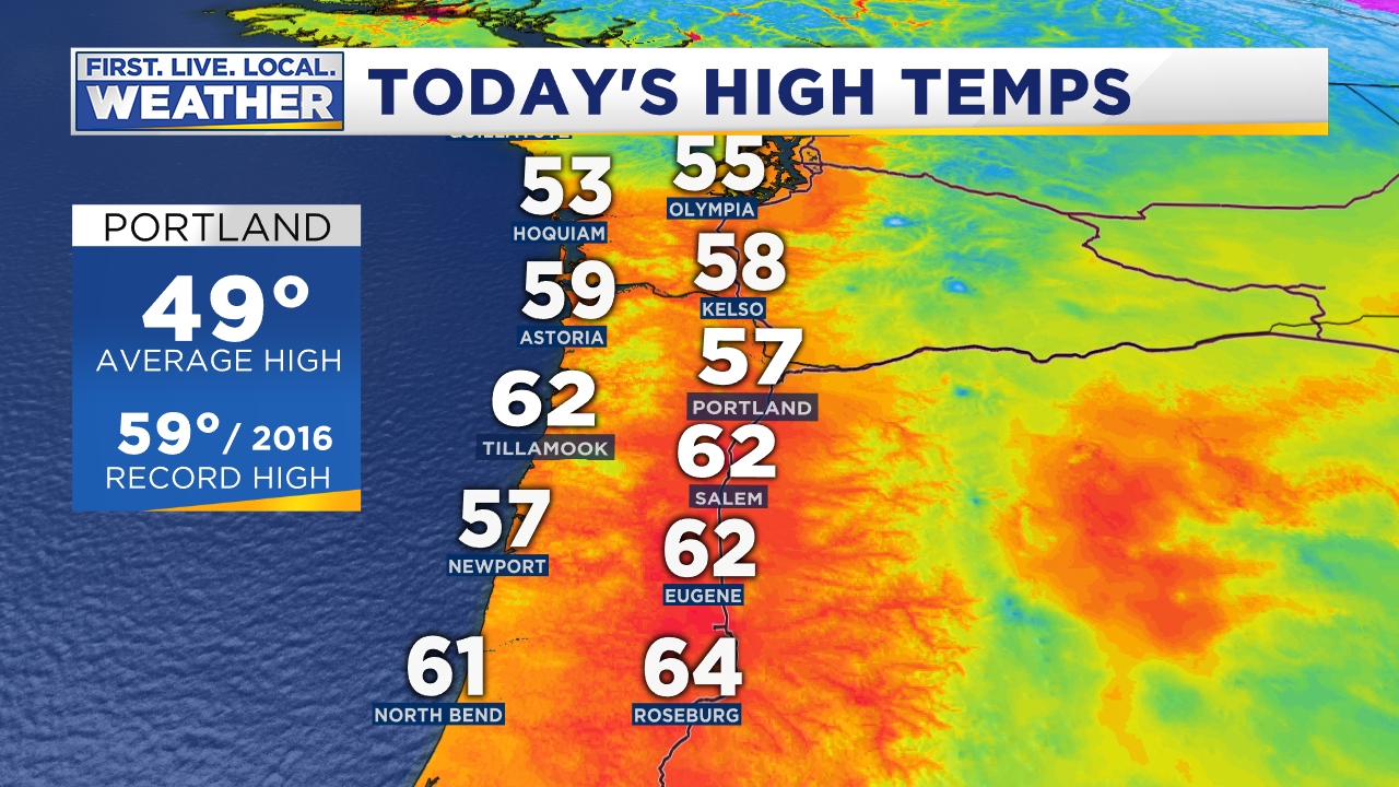
That produced some near-record highs and a very spring-like day today.

Salem hit 62, the 4th 60 degree day this month. Only 2 other times has Salem had 4 or more days in the 60s since record-keeping began in the late 1800s. It is our 3rd warmest January on record in Portland. The one bit of good news is that the Tuesday/Wednesday cool upper-level trough is still on schedule to move overhead (mentioned in last Monday’s post), dropping snow down to around 2,000′. So it’s fair to say we’ll get another 8-12″ in the Cascades.
But then an upper-level ridge becomes established either just to our west (late this week and weekend) or right over us (10-15 days from now). That dries us out quite a bit, and sends much warmer air overhead once again. Check out the slide show of the ECMWF: It starts on Tuesday, then this Saturday the 3rd, Tuesday the 6th, Friday the 9th, and finally two weeks from tomorrow…Monday the 12th. Dates are at the bottom right
This slideshow requires JavaScript.
Looks like the ridge is a bit “dirty” which means likely not all dry, but lots of clouds and extremely weak (& warm) systems moving through. Note it keeps the real cold air to the east. The GFS model looks pretty much the same 16 days from now:

Now you may remember last week I mentioned it would only take a slight shift westward with that ridge to allow cold air in from the north. That’s still a possibility and models have hinted at it over the past 3-4 days. But as of this moment none of them are showing that scenario.
WRAPPING THINGS UP
- There is no sign of a return to “real winter” conditions, no stormy weather or snow/ice/cold
- A very warm January is going to morph right into a warm start to February
- Cascade snowpack could take a hit later this week or beyond if we get a warm/wet system instead of a stronger ridge & sunshine. The snow conditions last week were likely the best we’ll see (along with Tues/Wed this week) for the time being.
- If you have studded tires and pipes covered, DON’T TAKE THEM OFF. That would be a poor choice right now. Mine are staying on. We can still easily get a cold arctic blast in the first two weeks of February, it’s even possible to have hard freezing the last two weeks of the month. Example = February 2006: 18 in Salem and 22 in Portland under cold east wind around the 20th.


 Posted by Mark Nelsen