February Winding Down, A Mainly Dry Work Week

February 24, 2020

7pm Monday…

Today was a slow weather day, after some excitement Sunday.  A strong cold front passed across the state yesterday, followed by quite a surge of southwest or westerly wind.  The peak gust of 45 mph at PDX was the highest of the season, which tells you how slow this winter has been weatherwise.  The “today” in the graphic refers to yesterday of course.

Wind Peak Gust PDX

Much stronger wind spread through the eastern Gorge and north-central & northeast Oregon.

Gorge Gusty Wind

Baker City reached near 60 at noon, then dropped into the 30s with a westerly gust to 67 mph…now that’s a real cold front!

Today’s forecast was a “bit off”.  Partly cloudy wasn’t too far off (really was mostly cloudy), but scattered showers popped up all day long and it wasn’t a dry day for some of us.  It has been appropriately noted with an “X” on the forecast report card.

In general we have another slow work week weather-wise.  Temperatures rise the next few days as a weak upper-level ridge moves overhead.  One weak system moves inland tomorrow evening, but we’ll be lucky to get anything more than a few sprinkles or a shower.  The next chance for real rain isn’t until Friday night or Saturday.  Beyond that time (first week or so of March) it should be a bit wetter, although not excessive.  The 12z ECMWF ensemble forecast gives a mean of 1.5″ through March 10th

ecmwf-ensemble-KUAO-indiv_qpf-2545600

I notice the GFS shows about 2″ during the same period.  Pretty typical early March showery weather.

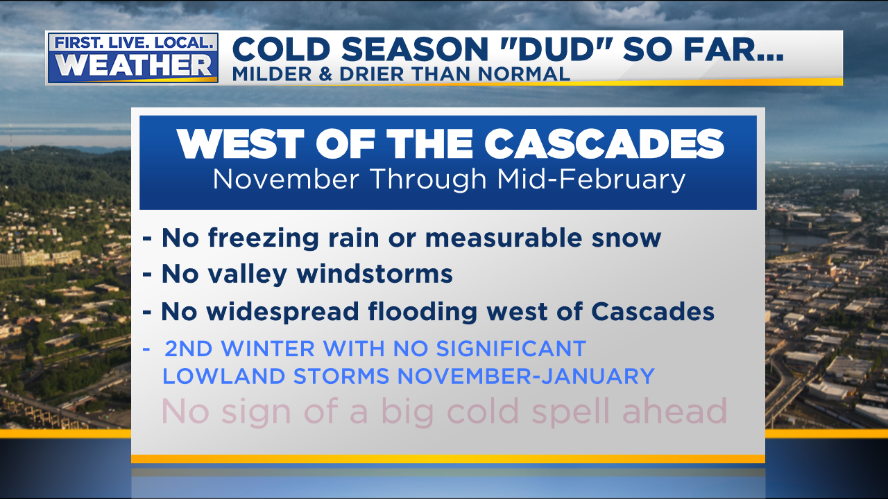
Winter still appears to be done as mentioned in last Wednesday’s post.  There’s no sign of a significant cold spell or freeze in the next 10+ days.  A nice warm up again this Wednesday-Friday, then cooler for that first week of March

ecmwf-ensemble-KPDX-daily_tmin_tmax_ecmwf-2502400

So I think the idea that “we’ll transition from winter to early spring weather” is still good for the next 10 days.  It’s also clear we’ll end up with a much drier than average February; probably ending up with less than 2″ for the month in Portland.  Each month since October (except January) has seen drier than normal conditions.

Rain PDX Last 10 Days

By the way, for you holdouts, the chance for snow goes down very quickly this time of year.  The chance for getting measurable snow in Portland; covering 80 years of data at PDX & NWS Forecast Office

LATE WINTER SNOW CHANCE PORTLAND

If you want ONE WHOLE INCH in the lowest elevations?  VERY tough to do from this point forward.  About as good a chance as getting measurable snow on Christmas!

Late Winter Snow Chance 1 or more PDX

Enjoy your (mostly) dry week!

Chief Meteorologist Mark Nelsen


Put a Fork in it; Winter is “Over” West of the Cascades

February 19, 2020

7pm Wednesday…

Our mild winter has been limping along for weeks. As I look into the last week of February and early March on our various models, it’s pretty obvious that

It’s time to put a fork in Winter 2019-2020.  This season is finished

So what kind of a statement is that?

It means I’m quite confident we’re done with most of our typical winter weather events.  But not all!  Read on…

First, this winter (December 1st to now) is running 5th warmest on record at PDX.  Those records extend back to 1940.  Spokane is 11th warmest out of 140, and Baker City is experienced its third warmest winter.  Olympia is at #4.  So not a record warm winter, but definitely at the upper end for many spots.

Looking at the models for the next 10-14 days…

  1. I don’t see an outbreak of cold arctic air.  For that matter I don’t see unusually chilly air for this time of year.   We have not seen a region-wide arctic air-mass descend across the Pacific Northwest since December 2013!  Sure, some cold-air intrusions to some areas at times, but no big arctic blast.
  2. I don’t see a setup for lowland snow west of the Cascades.  I thought we might be close next Monday, but the GFS model has finally caved in to the milder Euro/GEM models.

Point #1 on the graphic below is most important; the chance of a widespread snow/ice event in the metro area is dwindling quickly.  I mean the type of event that shuts down our area for a day, or even part of it.

Mark Winter is Over1

  • Other than the cold spell Thanksgiving Weekend that dropped the metro area into the low-mid 20s, we haven’t seen a hard freeze this winter.  It’s too late for that now (considering current forecast models).
  • Sure, we can still get a chilly east wind, but in late February and early March we don’t get long periods of the screaming cold easterly wind.
  • As for flooding, for the first time in my career we DID see some significant April flooding last spring.  But otherwise all of our big floods have occurred during the winter months.

What could we still see as we head into March?

We have seen March windstorms in the past and even one April event a couple years ago.   And of course in recent year’s we’ve seen close calls with snow in March.  Although it’s still far more rare than December-February snow.

Mark Winter is Over2

What actions can YOU take at this point?   Get those snow tires off and turn on the water to the chicken coop (I need to do that).

Mark Winter is Over3

There you go.  Basically it’s time to “de-winterize”.

To summarize:

We transition from late winter to early spring weather over the next 2-3 weeks as temperatures gradually rise.

Chief Meteorologist Mark Nelsen


A Dry Work Week, Plus Winter Winding Down

February 17, 2020

7pm Monday…

Today has been mainly dry across the area, with just a few light showers.  Officially in Portland we didn’t get measurable rain.  That means we’ve entered a 5-6 day dry spell!  We haven’t seen a setup like this since Christmas Week back in December.  During the 7 days starting Christmas Eve we only saw .03″ in Portland.  Actually we have not had five consecutive days without measurable rain since the first week of November!

Most likely there will not be any rain in western Oregon and SW Washington until Saturday evening.  Enjoy your 5+ dry days!  I have plans to clean up the yard, prune some fruit trees, go skiing, and get some sun on my pasty white skin. Oh, and work too.  A busy week…

The dry weather is due to weak upper-level ridging moving overhead tomorrow through Friday.  This keeps storms away.  Increasing offshore low level flow means a period of gusty easterly Gorge wind tomorrow afternoon through Thursday too.

Mark Jet Stream

Rainfall has been near to below average across much of Oregon and all of California the past 30 days

hrap-all-nw-30day_percent_anom-1940800

Of course Washington has been wet and NE Oregon as well (the last 30 days), much of that due to the atmospheric river event the first week of February.

Snowpack is running near normal, averaged across the state

or_swepctnormal_update

This cold season (November to now) has ranked as just about the most boring I’ve seen in my 29 years forecasting in NW Oregon and SW Washington.   Last year was similar, but then a cold/snowy February made for some fun weather times.

No windstorms & no stormy periods.  Do you realize we haven’t even seen a southerly wind gust to 40 mph at PDX this winter?  That’s very rare, in fact it hasn’t happened in the past 5-6 winters.  We’ve seen upper-level heights above normal over the eastern Pacific for large chunks of the winter (right now).  That keeps storms weak.

No widespread flooding.  Just some minor flooding in the north Coast Range.

No hard freeze/arctic blast.  PDX only dropped to 26…in November!  Outlying areas dropped as low as 19-22 at the same time during Thanksgiving Weekend.

No cold daytime highs.  We didn’t have even a single day where the daytime temperature stayed below 40 degrees.  An entire winter with no days in the 30s…that’s very mild.  That only happens every 10-20 years.

No measurable snow.  We’ve seen it close three different times, but nothing measurable at PDX so far.

No long periods of cold easterly Gorge wind.  Likely no one is complaining about this one, but we’ve escaped with no long or strong east wind episodes.

Winter So Far Intro

What’s Ahead?

Meteorologically we only have two weeks of “winter” left.  We consider March the first month of spring in the northern hemisphere.  The sun angle is now as high as it was just before Halloween, you have likely noticed that it feels warmer in the sunshine the last couple of weeks.

We sure aren’t going to have any hard freezes or widespread snow events in the next two weeks, so what #Sad winter we had around here is pretty much over.  I considered putting the fork in winter today, but we’ve got one more close call with low elevation snow in our 7 Day forecast.

Models are insisting a cold upper-level trough will drop through the Pacific Northwest late Sunday/Monday early next week. 850mb temps go as low as -8 to -9, plenty cold to get mixed showers or even all snow to sea level.  It appears we’ll get scattered showers during that time with onshore flow.  This isn’t a “real snow” setup for us, especially in the last week of February.  But it does mean, for the 4th time this winter, we could see patches of snow on the ground.  That is next Monday morning…if everything lines up JUST RIGHT.  At the least most of us will see some flakes in the air either late Sunday or Monday.

So in reality (just like the last three times) this won’t be affecting your life early next week.  But it would cause what we call “message confusion” if I put a fork in winter, then lots of us see snow in the air (or ground) 5-6 days later.

Enjoy the sunshine this week!

Chief Meteorologist Mark Nelsen


Holiday Weekend Rain & Mountain Snow; as Mild Winter Continues

February 13, 2020

7pm Thursday…

It’s already mid-February! Hard to believe March is only a bit over two weeks away.

Today has been a chilly day with cloud cover and a weak Pacific cold front passing overhead.  A much wetter system arrives Saturday.  That one should give us quite a soaking as a few waves roll up along the almost stationary front.  Total rain forecast from our RPM model through midday Sunday:

RPM Precipitation Accumulation

Have big plans for Valentine’s Day?  The good news is that I don’t expect much rain tomorrow.  Just very light showers lingering west of the Cascades.  The majority of the day will be dry.  Basically a slow weather day that shouldn’t impact your plans.

This winter has been very mild across the northern hemisphere.  In fact just today NOAA announced January 2020 was the warmest January on record for the entire globe.  Notice how much of the planet was above average last month.  And that’s without an El Nino in progress.  Our planet is warming…

January-2020-Global-Departures-from-Average-Map_0

Also interesting is the persistent area of cold weather over Alaska and western Canada.  Of course very little of that cold air moved south into the Pacific Northwest this winter (so far), leaving us with a much milder than average temps.  The Capital Weather Gang had a great article about the Arctic Oscillation contributing to the warmth the other day.  Good reading!  Notice the image below is November through January.

divisionaltavgrank-201911-202001

How does our meteorological winter (December-February) rank so far?  If we take December 1st through February 12th, it ranks as our 4TH WARMEST WINTER ON RECORD IN PORTLAND.  Records go back to 1940 at that location.  Some other locations around the PACNW:

Salem:  13th warmest out of 127 winters

Eugene:  7th warmest of 82

Olympia:  3rd warmest of 79

Redmond:  3rd warmest of 71

Pendleton: 6th warmest of 93

Snowpack is doing surprisingly well considering it’s been such a mild winter.  The big dump back in mid-January was a huge help.  Still a bit below average over the Cascades now, but above average in Eastern Oregon

or_swepctnormal_update

Willamette reservoirs begin filling in February, typically reaching full summer “pool” by early May.  The rain in late January and early this month has helped; I see Detroit Lake is up 30 feet from its winter low.

willamette

Speaking of snow, the three day President’s Day weekend is always big for snow play in the mountains.  That storm coming in Saturday will dump a good 8-12″ up there, with the warmest part of the system coming in Saturday evening.  At that point a rain/snow mix could show up as high as 3,500′.  But then cold air pours in Saturday night and a nice round of snow follows midday/PM Sunday.  So if you like stormy skiing, then Saturday is your day.  Colder with less wind/storming would be Sunday and especially Monday.

Snow Report 3 Days

The 18z ECMWF model says 12-24″ on Mt. Hood by the time we’ve mainly dried out Monday morning.

ECMWF Snow Accumulation Hourly

So what’s ahead?  More mild weather, but we could actually see three dry days next week!  We haven’t done that in awhile.

There’s no sign of any cold air coming down from Canada or lowland snow (even a wet/sloppy onshore flow snowfall).  The 12z ECMWF ensemble snow prediction for Salem the next two weeks which basically takes us to the end of February

ecmwf-ensemble-KSLE-indiv_snow_24-1595200

Which means it’s just about time for this right?

fork

Close, but never before Valentine’s Day.  It’s on the way…

Chief Meteorologist Mark Nelsen


Drier Weather Ahead After Widespread Flooding in Northeast Oregon

February 7, 2020

9am Friday…

Good news folks…we finally have some dry weather ahead!  After a very wet January, things have slowed down a bit weather-wise in most of Oregon.   The past 30 days have seen almost double the typical rainfall in Washington, and well above normal here in Oregon.  Yet drier than normal to our south.

anomimage

An upper-level ridge has been sitting just offshore the 2nd half of this week with lots of subtropical moisture streaming overhead.  This has brought flooding north of us in western Washington but kept most of the heavy rain out of Oregon.  Strong northwest flow coming down the backside of the ridge dumped a huge amount of snow on NE Oregon Wednesday night & Thursday, which then turned to rain.  The result has been widespread flooding in one of the drier parts of Oregon.  The Umatilla River near Pendleton has crested and dropped 2 feet after going into the MAJOR flooding category yesterday, 7 feet above flood stage!

umatiall

Here’s a pic from a viewer.

FB_IMG_1581040890735

The Grande Ronde river at Perry (upstream from La Grande) is at one of its highest levels on record.  That wave of water will be slowly passing through the Grande Ronde Valley the next few days, it’s a very flat valley so the water will be lingering.  Lots of roads/highways closed due to either flooding or slides over there.

lgno3_hg

The good news is that we’re drying out in general, with just one more weather system to go tonight and Saturday.  3 day precipitation forecast from our RPM model

RPM_RAIN_NWOREGON (2)

But check out the next five days…Monday through Friday next week from ECMWF model…very little!

ecmwf-deterministic-oregon-precip_120hr_inch-1768000

The drier weather is due to that upper-level ridge offshore nudging up against the West Coast.  It won’t be cutting off all the precipitation for the whole week, but systems passing overhead should be much weaker = less rain.

This also means mild temps ahead.  A couple days ago it was looking chilly with colder weather systems digging an upper-level trough over the West Coast.  Now models are keeping the ridge closer (no snow!) for next week, although expect some cooling still around Valentine’s Day.  Here’s the latest ensemble forecast of high temps around PDX.  A dip around late next week, but near normal through much of the next two weeks

ecmwf-ensemble-KPDX-daily_tmin_tmax_ecmwf-1033600

And strong hints that next week’s drier weather may not last.  See the resumption of rains beginning around Valentine’s Day.  The solid blue line is the operational model, the green bars are the average of all 51 members.  They both show mainly dry next work week, but then wet again as we head toward late February.

ecmwf-ensemble-KPDX-indiv_qpf-1033600

I’m taking a long weekend; will be back on the air Monday afternoon.  Enjoy the dry weather Sunday!

Chief Meteorologist Mark Nelsen


Last February’s Snowfall + Snow Poll

February 3, 2020

8pm Monday…

I’ve put up a poll on a blog post over at www.kptv.com site.  WordPress poll doesn’t work so well anymore.  If you’re interested head over here

There has been some discussion from time to time (since last summer) about last February’s snowfall at the NWS not being representative of the metro area.

Mark Snow PDX February

Here you go…the four measurable snowfalls in most of the metro area in February 2019

Picture1Picture2Picture3Picture4

Everyone got a little with the first event. Almost the entire metro saw 1-2″

2nd event: east and north metro scored big time with this one

3rd event: west metro won during third event, nothing in Vancouver and almost nothing far eastside

4th event: weak in general, but mainly west/south metro. Nothing in Vancouver

It’s interesting that downtown Portland didn’t do well in any of the events last year.  Wrong place each time.  But remember back in January 2017 the middle of the metro area scored, west side pretty good, but east side was weak.  It all evens out in time…

Now you can argue about it in the comments.

Chief Meteorologist Mark Nelsen


Welcome To February! Snow Showers Tonight Plus A Look Ahead

February 2, 2020

7pm Sunday…

Hope you are enjoying the Super Bowl on FOX12 or anything else you are up to this Sunday evening.  I’m on a bit later tonight, around 8:30pm or so once The Masked Singer finishes up.  That gives some time for a quick blog post to let you know what’s up weatherwise for this first week of February

Quite a change today from the low 60s Friday.  We only hit 45 today and we’ll spend most of Monday in the 30s and lower 40s.  A cold upper-level trough is passing over the Pacific Northwest this evening.  Earlier we saw a few scattered showers pop up in the chilly airmass, producing a mix of rain, hail, and graupel.  Those were driven by the increasing February sun angle producing surface warming that bubbled up into the cold air above.  Now that the sun has set, we’re finished with those.

KPTV 2017 Default Earth

We’ll likely remain dry through about midnight.  With partly cloudy skies temperatures fall down to around freezing most areas west of the Cascades too.

Models are in pretty good agreement that the line of showers offshore moves inland after midnight.  These will be light showers, but with temps around freezing ANYONE COULD SEE A BRIEF DUSTING OF SNOW west of the Cascades.  That said, some of us will be slightly above freezing = no sticking snow.  Other areas may get a rain/snow mix, then partial clearing AFTER the showers pass by could lead to a wet road freezing.

The result will be a random mix of four road conditions west of the Cascades for the morning commute in the lowlands from Longview to Eugene:

  1. Dry roads: where showers don’t pass overhead
  2. Snow-dusted roads: snow showers have passed over w/temps near/below freezing
  3. Icy roads: snow/rain showers pass by, then skies clear = black ice forms
  4. Wet roads: snow/rain showers pass by, but temps remain above freezing

All of these could occur within just a few miles of each other so tomorrow morning is definitely the type of morning to keep an eye on your car thermometer and morning weathercasts (here on FOX12 of course!)

And of course I could see a few school delays as well.  But this is not a “widespread snow” sort of weather setup.

Snow Tonight Forecast 1

What are models saying?  They don’t do very well with this real marginal/light precipitation setup so you can’t look at any one specific location and claim it will/won’t snow and stick right there.  But you can get a general idea.  Here’s our GRAF model, the lightest color indicates 0.2″ to 1″ in this case.

GRAF Snow Accumulation

The WRF-GFS thinks most showers go south, a little better chance in south Willamette Valley = no snow for most

or_snow24.36.0000

And the HRRR, just a very light dusting in spots

hrrr_snow7am

The message in general is the same…almost all of us will see our day progress as normal Monday, but a few wake up to a dusting of white.

Tomorrow should be a GREAT day…partly cloudy with a bright blue sky.  Chilly start and end but around 45 mid-late afternoon.  Tuesday will be similar, although lots of us will start in the mid-upper 20s.  I’ll go 28 at PDX for Tuesday morning.  Once again we can’t seem to reach the cold nights we saw back in November.

Winter Coldest Day Each Year

A weak ridge of high pressure sits overhead Wednesday-Friday, bringing a mild south wind and rainy weather those days.

Models are still going for a little cooling next weekend, although nothing that would bring snow close to sea level again.  By next Sunday all models are bringing an upper-level ridge close to us again.  The GFS ensembles shown here for:

gfs_sunday9th

But just 10 days away (Wednesday the 12th), the GFS is trying to bring very cold troughing down over us

m500za_f240_bg_NA

The GEM (Canadian) says nope, ridging is much closer

gem_wed12th

The ECMWF agrees with the GEM, keeping temps relatively mild, but a little on the cool side through mid-February

ecmwf-ensemble-KPDX-daily_tmin_tmax_ecmwf-0644800

We may dry out a bit too with a closer ridge.  ECMWF ensemble average (for Salem) shows only 1.5″ rainfall during the next two weeks.  Operational (blue line) only around an inch.

ecmwf-ensemble-KSLE-indiv_qpf-0644800

By the way, 3 of the past 6 Februarys we’ve seen significant snow in Portland.  We’ll see what happens this month, but nothing suggests we’ll see measurable snow in the first 10 days of the month.

Mark Snow PDX February

Chief Meteorologist Mark Nelsen