7pm Thursday…
It’s already mid-February! Hard to believe March is only a bit over two weeks away.
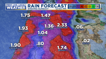
Today has been a chilly day with cloud cover and a weak Pacific cold front passing overhead. A much wetter system arrives Saturday. That one should give us quite a soaking as a few waves roll up along the almost stationary front. Total rain forecast from our RPM model through midday Sunday:
Have big plans for Valentine’s Day? The good news is that I don’t expect much rain tomorrow. Just very light showers lingering west of the Cascades. The majority of the day will be dry. Basically a slow weather day that shouldn’t impact your plans.
This winter has been very mild across the northern hemisphere. In fact just today NOAA announced January 2020 was the warmest January on record for the entire globe. Notice how much of the planet was above average last month. And that’s without an El Nino in progress. Our planet is warming…

Also interesting is the persistent area of cold weather over Alaska and western Canada. Of course very little of that cold air moved south into the Pacific Northwest this winter (so far), leaving us with a much milder than average temps. The Capital Weather Gang had a great article about the Arctic Oscillation contributing to the warmth the other day. Good reading! Notice the image below is November through January.

How does our meteorological winter (December-February) rank so far? If we take December 1st through February 12th, it ranks as our 4TH WARMEST WINTER ON RECORD IN PORTLAND. Records go back to 1940 at that location. Some other locations around the PACNW:
Salem: 13th warmest out of 127 winters
Eugene: 7th warmest of 82
Olympia: 3rd warmest of 79
Redmond: 3rd warmest of 71
Pendleton: 6th warmest of 93
Snowpack is doing surprisingly well considering it’s been such a mild winter. The big dump back in mid-January was a huge help. Still a bit below average over the Cascades now, but above average in Eastern Oregon

Willamette reservoirs begin filling in February, typically reaching full summer “pool” by early May. The rain in late January and early this month has helped; I see Detroit Lake is up 30 feet from its winter low.

Speaking of snow, the three day President’s Day weekend is always big for snow play in the mountains. That storm coming in Saturday will dump a good 8-12″ up there, with the warmest part of the system coming in Saturday evening. At that point a rain/snow mix could show up as high as 3,500′. But then cold air pours in Saturday night and a nice round of snow follows midday/PM Sunday. So if you like stormy skiing, then Saturday is your day. Colder with less wind/storming would be Sunday and especially Monday.

The 18z ECMWF model says 12-24″ on Mt. Hood by the time we’ve mainly dried out Monday morning.

So what’s ahead? More mild weather, but we could actually see three dry days next week! We haven’t done that in awhile.
There’s no sign of any cold air coming down from Canada or lowland snow (even a wet/sloppy onshore flow snowfall). The 12z ECMWF ensemble snow prediction for Salem the next two weeks which basically takes us to the end of February

Which means it’s just about time for this right?

Close, but never before Valentine’s Day. It’s on the way…
Chief Meteorologist Mark Nelsen

Decorative (non-fruiting) fruit trees are starting to blossom all over the area, a sure sign that Spring is here!
[…] range of the Southern Washington/Northern Oregon Cascades. According to Mark Nelsen’s most recent blog post, the December 1st – February 12th period was the 4th warmest on record for Portland since […]
I might venture back to Oregon City this week and to my old farm where my friends let me camp, Thanks Dave & Mac. I still have a tractor to tote back to Kamiah so this might be the week. It’s hard to camp during the 120 shortest and possibly coldest days of the year but I might just take a chance with the weather forecast warming and dry, and if the weather changes for the worse then maybe the X will let me stay at her place????
Still a ways out but looking like overnight next Sunday into Monday morning may be our next (likely last) chance of some wet snow flakes down to floor. Colder air pools in but may not be enough precip left. Nothing significant either way. It wouldn’t be a February in Portland without at least some conversational snow, right?
36 at 6:45 am, 36 at 9:00 am, windshield splat test positive, 36 at 11:00, 37 my high at 4pm, 36 at 6:00pm, 34 and precipitation stopping before 8pm. Even up in the foothills of Mt Rainier, you have plenty of disappointed moments!
Indirect correlation or not, interestingly today is the day that—a couple of weeks ago—some forecast models showed a possible Portland winter weather event.
Today it turns out was one of our few winter days this season with downright wintry weather!—low to mid 40’s and steady rain! The kind of day that most years would have been common. Not this year. Shave about 8 degrees and presto!
Boy Mark, that giant fork popped up without being expected; the scrolling was perfect to make it a real wow, then an OH NO THE FORK moment! Dang it anyway! I swear one of these days I’m moving somewhere with guaranteed snow!
Dreary, drizzly day here with a temperature of about 41F. I’m looking for a return of the sun tomorrow or at least on Monday (which is a statutory holiday here)
Who knows how trends will evolve going forward—all things considered?!
Boston, for example, has had many days this winter with rain and temps similar to what Portland typically would experience (rather than their often snowy pattern.)
While we here in Portland have had many winter days similar to typical Sacramento temps (but with a hint more rain.)
As Mark and others have pointed out, however, certain other zones have been more extreme—including some locations in the upper Great Lakes.
Less frustrating, I guess you could say, for those of us pulling for active winter weather; e.g. knowing that other zones have experienced similarly.
Models are still trying to show cooler weather but nothing cold and snow. If anything, I really want a good storm to come in between the 21st and the 24th. I’ll be heading to the Newport Seafood & Wine Festival that weekend. It’s been awhile since I have seen a storm come ashore.
Since we are going into what could be spring like conditions, hopefully we can see a lot of thunderstorms this season 🤗⚡🌩
Does anyone know if a Premium subscription to the Weather Bell site grants access to the Ensemble individual member charts that Mark frequently shows? I love those. Thanks
Yes, yes it does.
Beautiful sunny morning here- I can believe spring is coming with the forecast over the next few days. I still had a small patch of snow in my back yard last night, but that should be completely gone by this evening.
The fork was getting antsy in January. Let it loose, Mark!
That fork looks really sharp – could be painful when released! 🙂
Well, Valentines Day is tomorrow so I guess Saturday we can call it. I’m looking for some 60’s now anyway. Great to see stuff start to leaf out. Heading to San Diego for a week soon and when I come back I’ll be in full Spring mode. Bring it on!
There it is! Sort of 🤣