Winter Is Over In The Lowest Elevations

February 28, 2017

11pm Tuesday…

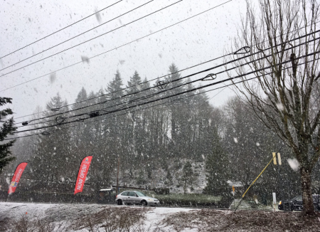
It’s time to stick a fork in this winter.  It’s been a wild one, but I think for those of us living at the lowest elevations the winter is finished and ready to come out of the oven.

What does THAT mean?

markwinterover

Could we still get a snowstorm?  EXTREMELY unlikely.  In March 2012 we had heavy/wet snow in the central/southern Willamette Valley mid-month, but it barely affected traffic in the lowest elevations of the metro area.  We sure don’t get frozen roads during the daytime from this point forward, in fact we’ve never had a daytime high below freezing after March 3rd.  You can take off your faucet covers since we’ve never had an “arctic blast” after the first few days of March.  We might get a few light frosts but that’s it.

This also means IF YOU PLAN ON DRIVING ONLY IN THE LOWEST ELEVATIONS you can take off your snow tires.

What parts of winter could we still see?  Exactly what we’ve seen the past few days…a brief wet morning snow that doesn’t affect our driving.  In fact that could happen several times in a cool March (Example = 2012).  We can also get a wind storm in the month of March.  That said, we haven’t had a wind storm since October!  This has not been a winter with lots of south wind by any means.  It’s been dominated by cool easterly flow…until now.

Meteorological winter is defined as the three coldest months of the year.  That is DECEMBER-JANUARY-FEBRUARY.  As far as we are concerned spring in the northern hemisphere starts tomorrow.  In fact in three weeks the sun will be halfway to its summer position so that seems perfectly reasonable.

It was sure a cold winter…in Portland the coldest in 38 years!  Note the #5 coldest ranking here right after that cold 1968-69 winter:

pdx_wintertemps_table

In other parts of the Pacific Northwest it was not as extreme.  For most of us around the region it was the coldest since 1992-1993.  There are just a few locations that saw a colder winter within the past 10 years.  That includes Seattle, Roseburg, Eugene, Medford, & North Bend.

The reason it was so cold was the thick snow cover that covered most lower elevations east of the Cascades from early December through early February.  That kept a cold low-level airmass over the region much of the time, remember the almost constant easterly wind through the Gorge?

markwinterwrap1


markwinterwrap2

For the record, the official snowfall at the Portland NWS forecast office (the official Portland total) is 11.2″ so far and my gut feeling is that will be the final number this winter.  The last time we saw measurable snow in the city was January 11th, the big snowstorm.  By the way we are exactly tied with Seattle for snow this season.

capture

For the first time in my career (all of it has been in Portland these 26 years) Portland had 4 ice storms and Eugene had 2.  Of course the thick icing was only in the eastern metro area and generally close to the Columbia River, but that’s normal.

In just under 3 weeks the Oregon Chapter of the AMS will hold it’s annual winter recap meeting and I’ll be presenting far more information at that time.  Afterward I’ll post a link to the presentation too.

Stay warm the next 7+ days as we wait for that first 65 degree sunny day!

Chief Meteorologist Mark Nelsen


Slow Warming This Week, Lots of Cascade Snow

February 26, 2017

8pm Sunday…

Today was a perfect example of what I call “conversational snow”.  That’s a snowfall that either does or doesn’t stick, gives us plenty to talk about, but doesn’t have much effect on our lives.  In the lowest elevations of the metro area the old rule held out for the 3rd or 4th time this winter…cold showers coming in off the Pacific with a southerly or southwest wind don’t give us significant or life-altering snow.  Hillsboro, Portland, Vancouver, & Troutdale all stayed above 36 degrees during the morning fun…too “warm” for snow to stick.  IF the showers/airmasses are cold enough…I think it was March 2009, then it’s possible to get heavy/wet sticking snow right down into the city, but the atmosphere overhead has to be colder than today.  In the hills around the metro snow stuck briefly in heavy showers.  This is from Timothy Rotter in SW Portland around 4pm near PCC Sylvania:

photo_timothyrotter

And if you went up at any elevation (well below 1,000′) and got under heavy showers, you likely saw more than this.  That includes the Coast Range and foothills of the Cascades.  Our John Hendricks got this image during the morning hours in the West Hills.  I think this location is somewhere around 700′.

photo_john

The next 48 hours we transition from the cold northerly flow into a slightly milder westerly flow of air coming more directly off the Pacific.  Remember this is the 2nd system that has dropped in on us from the north, the previous one was Friday.  IF there are any leftover showers tomorrow morning, there’s no reason snow couldn’t stick down around 1,000′ or even a bit below, but in the case of tomorrow AM the showers look very scattered = mainly dry.  Best chance will be along the west slopes of the Cascades and foothills.  That includes the hills in the west end of the Gorge.  The sticking snow level gradually climbs from around 1,000′ or just below tomorrow morning to around 2,500′ by Wednesday afternoon.  Between now and Wednesday we’ll see LOTS of clouds (especially Tuesday/Wednesday) and occasional very light rain showers in the valleys.  Meanwhile the westerly flow overhead means the mountains will scoop up LOTS of moisture.  Powder alert!  Take a look at snow forecast through Tuesday…a very heavy snowfall with quality snow due to the cold air.  12-20″ likely on Mt. Hood

rpm_snowaccum

With the clouds and light showers, it’s pretty obvious March will be coming in like a lamb, not a lion.   The saying of course refers to early March sometimes starting more like winter, but always ends on a calmer spring note.   Regardless, I think the fork is coming out this week, I don’t see much winter left!  Maybe something like this morning again, but that’s about it.

Fork2

Chief Meteorologist Mark Nelsen


Snow Level Around 1,500′ This Morning

February 26, 2017

As expected a mild southerly wind is blowing west of the Cascades this morning and has lifted the snow level up above 1,000′, actually closer to 1,500′.  Here’s a good picture from home this morning at 8:45am.

Bottom of pic in the canyon is about 900′ elevation, top of the trees in the distance is around 1,400′.  So the sticking snow elevation (the SNOW LEVEL) is up above 1,000′ in this location:

thumbnail_img_2437

Always remember SOUTH WIND = NO SNOW in the lowest elevations of the Portland Metro Area.  Okay, one time out of 10 we’ll get a dusting in this pattern.  Or with a really cold airmass coming onshore a couple of inches can fall in the hills in this pattern, but it’s very rare.  You either want calm conditions or of course the favored snow pattern with cold air already in place (calm) or pouring in out of the Gorge.

Enjoy your Sunday!  The steady rain/snow is about to change to showers and sunbreaks, it should be a much brighter afternoon.

I’ll be back at work this evening and see you on-air at 10pm.

Chief Meteorologist Mark Nelsen


Snowy Coast & Coast Range; Too Dry Metro Area For Snow

February 24, 2017

10am Friday…

The snow showers showed up at the Coast and in the Coast Range this morning, here’s a pic of almost 6″ in Jewell

photo_jewell

and then from Andi in Pacific City

photo_pacificcity_andi

Here in the metro area it hardly did anything at all and has been mainly dry.  No measurable precipitation at Portland, Hillsboro, Troutdale, or Aurora through 10am.  Sure, there were flurries and sprinkles around, but if the temperature is marginal for snow (32-34 degrees), you need some heavier snow showers to get it to stick (like in Pacific City pic above).  Most models were showing very light precip, but so far it’s been even lighter than they showed.  Luckily I didn’t jump on that wetter GFS model last night which implied several inches of snow west metro area today.

Now the daytime “heating” has taken over and there’s no chance for sticking snow the rest of the day.

Another wetter system comes through the region Sunday and that one should give more snow to the hills and just a mix again at the lowest elevations early in the morning.  Beyond that we’ll gradually turn warmer next week, although “warmer” just means temps coming up closer to normal.   So today and Sunday morning MAY be the last flirtation with snow for this season.  I hope…

capture

That is a cross-section showing the next 3.5 days temperature and relative humidity (green colors), along with wind barbs showing wind direction and speed.  The blue line is zero degrees (celsius).  You see the dip to sea level tomorrow (25/12 refers to 4am the 25th, Saturday).  Then a dip close to sea level again both Sunday and Monday mornings.  The reason I’m not real excited about low elevation snow Sunday is the southerly wind we’ll have on Sunday.  That almost always keeps us a few degrees above freezing and that’ll likely happen Sunday morning.  But that’s a day we’ll see lots of snow above 1,000′, could be a snowy drive into the Cascade Foothills and Coast Range too.  Keep that in mind if you’re travelling on Sunday.

Chief Meteorologist Mark Nelsen


Friday Morning Snow Update

February 23, 2017

4pm Thursday…

It’s a cool day with temperatures just into the low-mid 40s this hour.  At least it LOOKS like those brighter days of late winter even if it doesn’t FEEL like it.

Here’s the latest for tomorrow…first the TV graphic and then I’ll add more info below:

bmac-snow_textpanel

ADDITIONAL HIGHLIGHTS

  • Snow showers arrive around daybreak or just before that time in the metro area
  • Most of the snow showers will be on west and north side of the metro area
  • Whatever falls before 10am could easily stick with temperatures close to freezing
  • I doubt we’ll see anything other than slush on main roads for most of us
  • Many of us in the metro area will just stay dry or get flurries that barely stick.  This is what we call a “conversational snow”; one that won’t affect most of our lives.

COAST

With more moisture along the coast this is one of the better places to find snow tomorrow morning.  That means up to 1″ could fall on any of the beaches/coastal cities in the morning hours.  Mainly from Tillamook north

COAST RANGE

This is the snowiest spot…I expect 3-5″ in the Coast Range above 500′ or so.  Camp 18 could be a winter wonderland by 10am!  Expect snow-covered highways off/on throughout the day up there.

GORGE

Forget it, no cold east wind and mainly dry anyway.  I-84 totally clear with a high 40-45

SALEM/EUGENE

It’s unlikely either location gets more than a dusting, or it’ll just be a couple degrees too warm for any “stickage”

The big issue with tomorrow is lack of moisture (if you want 1, 2, 3″ or more snow).  A surface low pressure system will be dropping south along the coastline during the day, taking most of the showers with it offshore and over/west of the Coast Range.  That leaves the main population centers of the Willamette Valley and SW Washington with very light precipitation.  It will be cold enough between late tonight and around 10am tomorrow for snow to stick all the way down to sea level.  Beyond that time (midday and afternoon), it’ll be too warm for snow to stick at the lowest elevations.

That’s it for now, just got in from a school visit (very late!) and I’ll be on the air starting at 5pm…busy day!

Chief Meteorologist Mark Nelsen


Who Gets Snow Next 2 Days

February 22, 2017

6pm Wednesday…

Today was day #1 of our low snow levels; and it went by somewhat uneventfully with just mixed showers popping up during the afternoon.  In some spots hail or graupel covered the ground.  Check out Corvallis earlier today from Katy Kelly

photo_katie_kelly_corvallis

We are under a cool northerly flow in the upper atmosphere with an upper-level ridge over southern Alaska and a trough right over us.  That pattern continues through Sunday/Monday.

marksat_sfc

So we have 4 more days to go in which it’ll be cold enough for snow to stick down to near sea level in the late night or early morning hours (coolest part of the day) IF moisture shows up at the same time.  That’s Thursday-Sunday.  So let’s take it day by day…

THURSDAY:  Looks just like today with a mainly dry morning, then afternoon showers pop up over the hills/mountains and drift out over the valleys.  Because just about all precipitation falls during the midday/afternoon, temperatures will be too warm for sticking snow below 1,000′.  Even at that elevation you’ll be lucky to get a dusting tomorrow afternoon.

SATURDAY:  Should be a dry day with a chilly start then mostly sunny afternoon.  No moisture for snow even though it’ll be cold enough early.

That leaves us with…

FRIDAY:  This day appears to hold the best chance for sticking snow to sea level, mainly the first half of the day (before noon).  That’s because that little “L” (low pressure center) on the satellite picture above will slide down the coastline through the day, picking up moisture and sending it inland over Western Washington and Oregon.  The ECMWF model (surprise!) has been showing this for two days, but other models have now come into agreement with the general plan.  I’m thinking that ANYONE west of the Cascades could see a dusting, but the best chance is north of Salem and west of I-5.  Actually the BEST chance at the lowest elevations may be up on the North Oregon coast where more moisture will be moving south.  Here’s what I’m using on-air:

bmac-snow_textpanel

Note the ECMWF and WRF-GFS models both hint at snow over the metro area

ecmwf_snowfridaypm


wrf_snow_satam

As of now it appears unlikely we’ll see sledding in the metro area Friday morning; however I bet all of us will see lots of snow in the air attempting to stick at times.  In this type of situation a mixing southerly wind often dashes our chance for sticking snow at the lowest elevations.   But in this case there will be very little southerly wind since the low is coming at us from the northwest and sliding by to the west.

Another low moves south on Sunday which COULD give us a Friday repeat.  But the atmosphere appears to be slightly warmer which may keep sticking snow up around 1,000′ and higher, or it may be just barely cold enough again…a very close call.  It is very interesting that 41 out of 51 ECMWF ensemble members produce at least 2″ of snow over the Portland area by Sunday afternoon, lending some credibility to the thought that we’ll get at least a little white at some point in the next 4 days.   That 2″ or more would include both Friday and/or Sunday snow combined.

Beyond Sunday, the chance for snow down to 1,000′ or lower goes away for at least a few days, or for good this season…we’ll see.

Chief Meteorologist Mark Nelsen


Great American Solar Eclipse: 6 Months Ahead

February 21, 2017

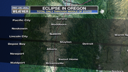
We’re only 6 months away now from the most anticipated astronomical event of our generation in Oregon.  The total solar eclipse will soon be here; I hope you have a plan to see it.  It will NOT be visible in any cities listed on this map:

markeclipse_2017_a

It’s unlikely the idea that “I’ll just drive down to Madras or Salem for the day” is going to work.  I’m quite confident US 26 over Mt. Hood, US 97 through Central Oregon, or I-5 Eugene to Portland can NOT handle hundreds of thousands of people converging on the center of the state at once and then leaving a few hours later.  Picture that December 14th snowstorm traffic disaster in the metro area, but spread over half the state plus you should add a few hundred thousand cars from California and Washington.  Get the idea???  Most campgrounds and hotels have been booked for months/years within the path of totality.  I have a plan to start camping at a certain somewhat remote mountain lake (lakes) starting Wednesday, 5 days ahead of time.  We’ll see how that works since it’s first come-first serve at that campground.  If that doesn’t work, I have one more backup plan.

You need to be in the shaded area to at least have a brief glimpse of a totally covered sun at midday.  The closer to the center line you are, the longer the eclipse:

markeclipse_2017_1


markeclipse_2017_2

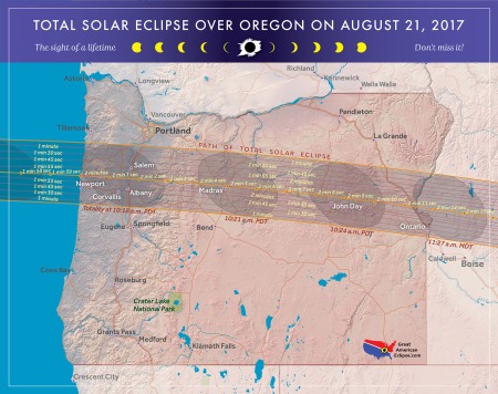
Here’s a great website https://www.greatamericaneclipse.com with even more detailed maps like this one:

tse2017_oregon


Chief Meteorologist Mark Nelsen