Portland’s Driest April In 50+ Years

April 28, 2020

11pm Tuesday…

Today was another very nice spring day.  Temperatures rose into the lower 70s west of the Cascades (except along the coastline).  This is what we typically see around Memorial Day, still a month away.

web_ORWA_HIGHS_Today_West

Every day except the first four has been at/above average as well.

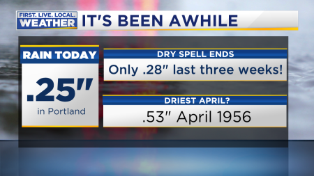
Do you realize this is the driest month in Portland since last July?  That’s very dry for April.  It looks like we’ll see less than .20″ rain coming up with a weak system Wednesday evening and early Thursday.  That means we end up with less than 1.00″ for the month.  We haven’t seen that since 1966.

MarkDrySpells April

And what a change from the past few years…I remember the closed sports fields (standing water) in 2017 & 2018.

MarkDrySpells April2

The warm and dry April has taken quite a toll on the mountain snowpack, it’s melting much quicker than what we’d typically see.

Compare the April 1st “snow water equivalent” to the 28th.  Below 50% of average now in parts of southern Oregon and close to that 50% number in central Oregon.  These numbers will continue to drop the next 10 days since we see more warm weather next week

This slideshow requires JavaScript.

What’s ahead?  I see more of the same…drier and warmer than normal the next 7-10 days.  But that DOESN’T mean totally dry weather.

A strong upper-level ridge across the western USA is keeping weather systems very weak as they move by the Pacific Northwest.  This is tomorrow.

ecmwed

That ridge weakens quite a bit and a cool airmass attempts to move inland this weekend…this is Sunday.  Notice below normal heights across the entire northeastern Pacific, but it’s not directly over us.  Showery, but not crazy wet or cold.

ecm_sun3rd

But by the middle of next week the warm upper-level ridging returns, this time perhaps directly overhead

ecm_wed_6th

These maps are all from the European model ensembles, but other models are similar.  This COULD lead to our first 80 degree weather next week.  For sure we see another spell of mainly dry weather after this upcoming weekend.  This is 24 hour rainfall for each of the GFS ensemble members (one horizontal line per member) centered over the northern Willamette Valley.  You see the weekend showers, then very few members are forecasting significant rain next week.  Many are totally dry.

gfs-ensemble-all-KMMV-indiv_qpf_24-8075200

So, it’s been a nice spring but we could sure use a major week-long soaking sometime in May!  For now I don’t see any sign of that happening.

Chief Meteorologist Mark Nelsen


April Turns a Bit Wetter

April 22, 2020

10pm Wednesday…

It finally rained today!  Not exactly a soaker, but saw just about as much rain today as we’ve seen in the past three weeks…it’s been very dry.

Rain Record 2

It really was a soaking in the south Willamette Valley with more than 1/2″ down there

Rain Metro Today Databound

The first 20 days of April were the driest “start” to the month since 1990; very unusual to only see 4 days w/measurable rain in the first three weeks of the month!  This graphic is for the 1st-20th

MarkDrySpells April

It appears this is just the start of several showery days.  A warm front brings a few sprinkles Friday, then another wet system comes in Saturday morning.  We’ll likely get another 1/4 to 1/3″ rain out of that one.  Models are showing a 3rd system moving inland Monday with another 1/4″ or so.  If we get lucky maybe we’ll see a weekly total of 1″ here in Portland.  That’s long overdue.  Still, as you see above we are running well below normal for just April.  February & March were dry as well.

So get used to lots of clouds, a little bit of sun at times, and some showers the next five days.

By the way, I’ve been showing a “film” on this evening’s shows from April 22nd 1961.  On that date it snowed in parts of the Portland metro area.  I bet it wasn’t cheap to own a quality color film camera in 1961!  But Ronald Myers did; the film shows snow in Washougal

April Snow Historical Video

It’s interesting that snow only covered non-paved surfaces…tough to get anything to stick to “warm” pavement the last week or so of April.

April Snow Historical Video2

I checked the weather records from PDX for that day; a LOT of precipitation (.95″).  The low was 33 and high was 43…extremely cold for this late in spring.  I’m guessing it was a stalled post-frontal precipitation band.  If it was a “showers/sunbreaks” day it sure would have been warmer than 43 at PDX in the afternoon since 850mb temps were around -4.  Freezing level in the morning was way down around 2,000′ or a little below.

I’ve been busier than normal the past two weeks since we started some “Mark Knows” weather lessons in the evenings.  These are 15-minute Facebook live postings covering different topics that kids (or adults on Happy Hour) might be interested in.  I’m off the next three days, but next Monday we’ll talk earthquakes.  Tune in to my Facebook page (@marknelsenweather) 7pm Sunday.

Stay dry and enjoy the rain…we need it!

Chief Meteorologist Mark Nelsen


April’s Cold Start Just A Memory Now

April 16, 2020

6pm Thursday…

Today has been another spectacular spring day in the Pacific Northwest.  Skies have been mainly clear from the coastline to the Idaho border.  The GOES-17 image from 5pm…

satellite

We have a moderately strong “downslope” & “offshore” in progress.  That means wind has been coming down off the Cascades and through the Gorge, then heading westward over the Coast Range and down over the beaches.  In the warm season this gives us above-normal temps.  Check out the highs so far today, especially the warm coastline…all 70s!

Todays Observed Highs OrWa 2017

Today is the 5th day at/above 70 so far this month.  This is the first time, since that crazy warm April 2016, that we’ve seen so many 70+ days

April 70 Degree Days

At mid-month we’re running just slightly above average temperature-wise. All the more impressive since the first 4 days were very chilly (compared to average)

Almanac Monthly Temps So Far

We are at “mid-spring” weatherwise.  It started 45 days ago and ends 6 weeks from now at the end of May.  How has it been?  DRY is the big story, we’re running well below average since both March and now April have seen well below normal temps

Spring Rain So Far2

March was a slightly chilly month, but now the warmer than average weather in April is
“cancelling” that out.  Basically we’re running about normal with respect to temperature since March 1st.

The soil is very dry in our area, in fact today I went out and watered some fresh forest trees (hemlock+fir) I planted just three weeks ago.  I don’t think we have a soaking rain coming in the next week for those little trees.  Does it seem like we’re seeing more dry springs lately?  If you think so you’d be correct; we’ve only seen one wet mid-late spring out of the past six!  I’m referring to April plus May as you see in this graphic

Spring Rain So Far

Long term our springs have been turning wetter in our area.  Just yesterday I checked to see if there were many Aprils with less than .30″ rain in the first half of the month in Portland.  I was surprised to see that there were a bunch!  Almost all from the 1940s-60s, but then very few after that time.  Interesting stuff, likely cyclical?

What’s ahead?  

  1. Think June for tomorrow.  Leftover offshore flow in the morning, then the wind goes calm through maximum heating hours in the afternoon.  This is a perfect setup for the warmest day of the week.  My chart says somewhere between 74 & 80 for a high temp at PDX.  We might be conservative forecasting 75, but we’ll be close
  2. A weak upper-level disturbance drops out of Canada on Saturday.  This will set off a few showers.  Along with onshore flow, that’ll drop our high temps back to normal Saturday along with lots of cloud cover.
  3. Sunday-Tuesday we’re back to pleasant weather with weak upper-level ridging overhead…64-68 degree highs are likely…no rain

The next real chance for rain appears to be the 2nd half of next week.  Models are trying to bring in some westerly flow and some systems from off the Pacific.  This would be more typical April weather with showers at times and lots of clouds.  The ECMWF ensemble “qpf” chart shows very good agreement on some sort of mid/late week soaking, or at least more than 1/4″ of rain.  Standards for “a soaking” are a bit low right now.

ecmwf-ensemble-KPDX-indiv_qpf_24-7038400

So…enjoy the pleasant April weather for the next 5 days (minus a few showers Saturday), and keep the pots on your deck/patio watered.

Weather Office Coronavirus Update:  All is going well here.  We are all healthy.  Brian and Jeff are still working from home.  Andy, Anne, & I continue to work here at the station.  Along with the rest of our coworkers, keeping about half at home really spreads us out.  Plus we practically get the kitchen to ourselves!!!

I have backed off blogging, not just due to slow weather, but we’re doing something new for the next few weeks.  We’re calling it MARK KNOWS.

These are quick weather lessons each weeknight through early May on our FOX12OREGON Facebook page; a live Facebook event in which you can ask questions.  Are your kids bored?  This is sort of a “weather classroom”.  Each weeknight at 7pm one of us (mainly me) will take on a topic.  Last night I talked about rainbows and quadruple rainbows.  Tonight at 7 we’ll make a cloud appear in a bottle, plus explain “blue clouds”.  Feel free to join us!

Mark Knows Weather Lessons Promo

Chief Meteorologist Mark Nelsen


First 70 degree days of 2020 ahead!

April 7, 2020

8pm Tuesday…

After a very cool two weeks, the Pacific Northwest has “turned the corner” and now we’re seeing more typical April weather.  In fact temperatures will be near or above normal for at least the next week.  Plus, we’re headed for our first 70 degree day of 2020 tomorrow!  This is the typical time of year we see our first 70 degrees.

First 70 Degree Day Heatwave

Over the past 30 days most of the western USA has been experiencing below average temperatures.  Only the yellow/orange colors on this map represent warmer than average weather:

anomimage (1)

Precipitation has been below normal as well…in this case the colors yellow/orange on the map below represent drier than typical conditions over the past month:

anomimage

High pressure is building offshore and upper-level maps show that ridge cozying up to the West Coast the next two days.  Right now:

jetnow

Thursday:

jetthursday

But then the ridge weakens a bit and shifts a little farther west again.  This is Easter Sunday.  Much of the nation east of the Rockies will see some cold Easter Egg hunts.

jeteaster

For us?  The strong ridging just west of us the next week means little or no rain.  That’s the easiest part of the forecast.  Then it’s a matter of how warm we get the next two days and how much cloud cover Friday/Saturday as a weak disturbance moves by.

First the warm weather.  Today we’ve seen relatively strong “onshore flow”, that’s air flowing from ocean inland.  But models show 2-3 millibars of easterly flow through the Gorge and over the Cascades by midday tomorrow.   Easterly wind from late March to mid-October is a “warm” wind.  That’s warm relative to normal.  Not like that cold east wind from Halloween to St. Patrick’s Day.   The WRF-GFS model from UW shows this at 2pm:

slp.33.0000

Tomorrow we add in 850 millibar temperatures (temp at 4,000′ or so) of +10-12 deg. celsius; quite a bit warmer than the +4 we saw today.  Then add all-day sunshine both tomorrow and Thursday.  Taking a look at my warm season “magic chart” for April, historically we have seen high temps at PDX between 72-80 degrees with this same setup.  In 2009, we hit 78 at PDX on April 6th with similar conditions. Those 80 degree highs on my chart were likely later in the month.  So, our forecast of 72 tomorrow and 74 Thursday seems good.  It’s quite possible we hit 70 tomorrow and 76 Thursday instead.  Or 73/73.

You get the idea…it’s going to feel like May for the next two days!

Onshore flow returns Friday with morning clouds, then more of that cool onshore flow might even give us a sprinkle or drizzle Saturday.    This is our only chance for rain in the next 6 days.

As cold air surges south out of Canada Saturday night and Sunday, we get another round of offshore flow.  Although the airmass will be cooler, this means Easter Sunday may just be sunny with temperatures in the lower 60s for your egg hunts.

THE LATEST ON WORK CONDITIONS HERE AT FOX-12

We are still doing some serious “social distancing” here at KPTV/KPDX like many of you.  In the past 10 days two of our meteorologists have “left” the office.  Both Brian MacMillan and Jeff Forgeron are broadcasting from home.  That’s not because they/we have any virus issues, but to move us farther apart.  Fewer people in one space = good.

91049545_10105149758220313_4244000830358814720_n

jeffpic

It’s amazing; with today’s technology we are able to perform just about all tasks from home that we can do at work.  20 years ago this wouldn’t have been possible.

The rest of us are still working here.  I have to admit I don’t mind working alone in this environment at all.  I go most of the work day without getting physically close to coworkers as mentioned in a previous post.

Stay healthy this week and enjoy the sunshine!

Chief Meteorologist Mark Nelsen


48 Years Ago Today; The Only OR/WA Killer Tornado on Record Strikes Metro Area

April 5, 2020

It’s pretty well-known that the Pacific Northwest isn’t in “tornado alley”, but we do occasionally get weak tornadoes.  Official tornado counts in the USA go back to around 1950.  Since that time in western Oregon, plus the SW Washington counties, 85 tornadoes have been reported.   That’s 85 in 70 years!  Obviously they aren’t too common.  The vast majority are weak; EF-0 or EF-1 category.

Tornado How Many Each Category

There have been three within the past year, but all were EF-0 causing minor damage.  Lots of us remember the Manzanita tornado in October 2016 and Aumsville in December 2010.  Those both went right through the middle of small Oregon towns, a rare occurrence and were relatively strong.

The Last 8 Tornadoes

Tornadoes come out of strong thunderstorms and we don’t get many of those west of the Cascades.  That’s the main reason we don’t see tornadoes very often and when they do show up they are usually weak.  There is a bit of a tornado “season” both in late spring and fall.  Notice how rare they are in mid-winter and mid-summer?

Tornado Season Stats

Tornadoes RARELY kill people in our area but it happened just once.  That was on this date in 1972.  6 people died and 300 were injured.  I was just a little 3-year-old kid (living in Hood River county) so I don’t remember it, but I know many of you older folks do.

Storm Summary

  1. A spring squall line with heavy showers and thundershowers swept through the region behind an early morning cold front.  Basically we were in a “showers and sunbreaks” weather pattern we often get behind cold fronts.
  2. Around 1pm a tornado dropped out of a thunderstorm near NE 33rd and Marine Drive in Portland.  This was just west of PDX and quite close to the National Weather Service office (at the airport).
  3. Tornado quickly moved across the Columbia River and through central/east Vancouver on a 9 mile trek toward Brush Prairie.
  4. The deaths all occurred in a several-block stretch.  From around the Fort Vancouver H.S. track to NE Fourth Plain and NE Andresen Rd.
  5. Just a few minutes later the tornado was gone after skipping out to Brush Prairie; lifting off the ground several times.

Tornado Vancouver 1972_a.png

Tornado Vancouver 1972

It’s easy to find lots of details about the tornado online; this link gives a detailed accounting of the storm as it moved through Vancouver:  https://www.historylink.org/File/8099

And here’s the official detailed storm survey/summary from the National Weather Service:  https://www.weather.gov/media/publications/assessments/Tornado%20Vancouver%20WA%201972.pdf

Ogden Elementary school was not rebuilt in the same location.  Instead a “new” Ogden Elementary was built about 3/4 mile to the northeast in just 18 months!

Chief Meteorologist Mark Nelsen