Record Warm March

March 30, 2015

Can you believe 5 of the past 12 months we’ve seen all-time record warm conditions in Portland?  Yep, August, September, October, February, & now March are the warmest in Portland Airport history:

MarkTempDeviation_PastYear2

There are two reasons.  For one, there has been a tendency for upper-level ridging to hang around the West Coast or eastern Pacific for much of the past two years.  The other is the unusually warm eastern Pacific ocean waters, also called “The Blob” over the past 18 months or so.  You can see it on the sea surface temperature anomaly map:

sst_anom

One of the results of all the warm weather is the growing season running well ahead of schedule.  My apple trees are beginning to bloom; these typically bloom a month from now.  Chris Markes was out in the Hood River Valley today and says it is already at the peak…a good three weeks ahead of the main blossom festival time.  So get out there within the next week!

chrismarkes_blossoms

There have been several periods over the past year where the ridge has broken down and we return to a wet & cool weather pattern for a week or two, or three.  This is happening again for at least the first couple weeks of April.  Between now and April 15th there will likely be more snow above 5,000′ than we have seen since December!  Lots of showers in the valleys too.  Let’s just hope for no frost to ruin the blooming trees.

Chief Meteorologist Mark Nelsen

fds


Monday: Last Warm & Dry Day

March 29, 2015

10pm Sunday…

You’ve got less than 24 hours to finish up any projects that need more than a few hours of dry weather. I see a long stretch of cool & wet weather beginning tomorrow night.

MarkHeadlines_Spring

It really does look like payback time for the unusually warm end to winter (February) and start to spring (March).  The latest numbers for this warm period are amazing…

MarkWarm_60DegreeHighs

A quick look further back in time shows only in early spring 1992 did we have as many 60 degree days as we’ve seen this year!

Our persistent ridge of high pressure that’s been sitting overhead or to the west of us for the last few months is going to take a break.  It appears the ridge is going to disappear for at least the first half of April.  That doesn’t mean the rest of spring will be cold and wet, we don’t know that.  It just means we’ll make up some snowpack in the Cascades.  Too late to salvage the ski season of course now that Spring Break has finished and we move on to warm weather activities, but it will help the drought situation in some spots.

How much rain ahead?  The GFS model shows around 2.00″ over the next 10 days.

imageControl

ECMWF model isn’t quite as wet, more like 1.00-1.50″.  Both are wetter than normal for this time of year.

Chief Meteorologist Mark Nelsen


Spring Break: Vacation Time

March 18, 2015

Wednesday, March 18th…

spring-break

I will be posting very little (or not at all) during the next 10 days.  It’s Spring Break time in Oregon and I’m taking a vacation with the family through Saturday the 28th.

I’ll be back at work on Sunday the 29th.

Chief Meteorologist Mark Nelsen


Sunday’s Windstorm Wrap Up

March 16, 2015

When I visit schools and other organizations I often talk about how good our forecasting is getting nowadays compared to 25 years ago when I started.  I have sometimes said “we’ll probably never be surprised by a major windstorm again“.  We came close both in October and yesterday.  Not a whole lot of warning.

We sure didn’t see a major regionwide windstorm this year, like 1962, 1981, & 1995.  But we have seen 3 very impressive windstorms in the Portland metro area.  Each of those put at least 70,000 PGE customers out of power at one time.

It’s very interesting to note that all 3 low pressure center paths were similar; steeply south-southwest to north-northeast.  That’s different from more of a westerly angle like WSW to ENE. That is excellent for getting a major windstorm here.  This one bottomed out only just below 1000 millibars!  Hard to believe we saw widespread gusts 45-60mph with that isn’t it? The low pressure center made landfall right around Hoquiam. The December storm bottomed out around 973mb, and the October storm was around 980 mb.

Models had trouble with all 3 storms this year, and two of those storms occurred with only about 24 hours of warning (this one and October).

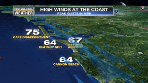
Here are the final peak gust numbers in our area:

MarkWind_PeakGustPDX

PLOT_Wind_Metro_PeakGusts_MANUAL

PLOT_Wind_Metro_PeakGusts_MANUAL2

For Salem, Hillsboro, & Battle Ground this was the strongest storm of the season…stronger than December.  The strong wind gusts were more evenly spread around the region.   Look how the Oregon Coast saw strong wind this time as well.

MarkCoast_PeakWindGusts2

MarkCoast_PeakWindGusts

In December Portland saw higher gusts than many coastal locations, which was strange.

The problem this time around with the forecast was that models were having real trouble deciding where a wave along our very wet frontal boundary would track.  Look at the surface map for Sunday 5pm from the NAM-MM5 and WRF-GFS initialization.  Looks like a low pressure center around 996-1000mb just moved inland and is centered near Olympia.  This is what actually occurred.

nam_Sun5pm_initialization wrf_Sunday5pm_initialization

Now take a look at the forecast for this time from FRIDAY MORNING:

nam_Sun5pm_48hrfcst wrf_Sunday5pm_48hrfcst

At 48 hours away neither is close to reality.  NAM has a low along the frontal boundary in eastern Oregon and the WRF-GFS is spinning something around off the southern Oregon Coast.  These are the last maps I saw Friday evening before the 10pm show.

Let’s move to 36 hours out.  Forecast for the same time from SATURDAY MORNING’S RUNS:

nam_Sun5pm_36hrfcst wrf_Sunday5pm_36hrfcst

Now it’s very interesting and both models agree…some sort of gusty wind event is on tap for late Sunday evening.  The low is supposed to still be off Newport at this time.

Jump ahead to SATURDAY EVENING’S FORECAST…just 24 hours away from our storm:

nam_Sun5pm_24hrfcst wrf_Sunday5pm_24hrfcst

Both are faster, the GFS is getting quite close to reality.  At this point it’s looking like a minor windstorm is on the way

Jump to SUNDAY MORNING’S FORECAST, the last before the event:

nam_Sun5pm_12hrfcst wrf_Sunday5pm_12hrfcst

Timing has speeded up again!  NAM is very strong and just about right on for placement.  The GFS ended up being too fast.  They both show a perfect setup for strong wind.

So I’d say models latched on around 24-36 hours out and once they did the surface low pressure intensity forecast was close to reality from that point onward.  The larger scale models (GFS/ECMWF/NAM etc…) were similar to these.

Chief Meteorologist Mark Nelsen


ECMWF Weekly Charts

March 16, 2015

I’ll do a summary of the storm late this evening between shows, but for now I’ve got the 4 weekly maps from last night’s run of the ECMWF.  Still ridgy along the West Coast or just offshore through the period.  That sure doesn’t mean DRY through mid-April, but it means most likely we’ll AVERAGE warmer and drier than normal.

Week 1

500za_week1_bg_NA

Week 2

500za_week2_bg_NA

Week 3

500za_week3_bg_NA

Week 4, this goes through April 12th.

500za_week4_bg_NA

So no change right?  Well the 12z ECMWF today looks a little different to me.  On the last image (Day 15, March 30th), lower than normal heights would imply cool and showery over the West Coast:

ecm_15days_31st

Hard to tell if it’s a transient pattern for just a few days or if the model is changing the big picture.

Chief Meteorologist Mark Nelsen


3pm: Gust to 58 at Portland Airport

March 15, 2015

Quite a decent windstorm, especially considering the surface low pressure center isn’t very deep.  Definitely the windiest March day we’ve seen in at least 16 years.

Peak gusts as of 3pm:

It appears the storm has peaked south metro area and Salem.  The strongest gust at Salem was 2 hours ago…

Portland Airport: 58

Vancouver: 46

Hillsboro: 54

Troutdale: 48

McMinnville: 51

Salem and Aurora have seen winds decrease slightly from their peak in the previous post.

Mark…


Wind Storm…Strongest of Season at Salem

March 15, 2015

2pm…

Power going in/out here at home so I’ll be brief.

Wind has arrived a couple hours early as pressures jump to our south and the southerly wind races up the valley.  Peak gust of 58 mph at Salem at 1:20pm is stronger than either of the previous storms this season.  I see lots of power outages down there.  About 20,000 so far in PGE’s territory.

Other peak gusts as of 2pm (mph)

Portland Airport: 48

Hillsboro: 44

Vancouver: 43

Troutdale: 37

Aurora: 59  (that’s just about as strong as the December storm in that spot)

McMinnville: 46

Very warm temps with the air mixing down well from above…into the 60s.  That almost always happens in windstorms in our area.

Wind will continue for a few more hours and then die down quite a bit around sunset or a bit before.

Chief Meteorologist Mark Nelsen