Time For Those “Almanac” Forecasts

August 30, 2018

6pm Thursday

Do you ever feel the urge to pick up one of those “Farmer’s Almanacs” just to see “what’s going to happen this winter”?  Or maybe you’ve seen some forecasts floating around online?  Apparently a lot of people do!  Here’s the Old Farmer’s Almanac forecast for this coming winter

Farmers Almanac Forecast Is Crap 2a.png

Warm and wet, but mild and snowy eastside…okay…

Now the Farmer’s Almanac forecast.  Yes the apostrophe is in the correct place on this one.

Farmers Almanac Forecast Is Crap 2b

I wonder what the difference is between TEETH-CHATTERING COLD vs. BITING COLD vs. STINGING COLD?  Hmmm…

But how accurate are these forecasts?  Well, it’s not too hard to find opinions, for example:  “…IT NAILED THE SNOWSTORM ON CHRISTMAS EVE LAST YEAR!”.  But there are very few studies looking at its accuracy.  They claim 80% accuracy…wait, I just choked up laughing…

Jan Null at Golden Gate Weather Services here has checked the Old Farmer’s Almanac accuracy in the past, rarely does it do well.

Brian Macmillan and I put together a presentation several years ago based on 4 winters of Old Farmer’s Almanac forecasts.

Farmers Almanac Forecast Is Crap 1

We didn’t analyze any sort of “snow/cold” forecasts because those are quite subjective; just how the temp and precipitation forecasts compared to reality here in Portland.

MarkOldFarmersAlmanac2

The Old Farmer’s Almanac was correct on precipitation anomaly (month-wise) only 50% of the time during the 16 months we analyzed.  As you can see the temperature forecasts (below) were even worse…OFA is wrong far more often than right.

MarkOldFarmersAlmanac1

The conclusion?  These forecasts are often terrible.  I’m quite confident no one is able to forecast daily, weekly, or monthly…many months ahead of time.

Chief Meteorologist Mark Nelsen


Much Cooler Thursday Ahead; But A Very Nice September Start

August 29, 2018

7pm Wednesday

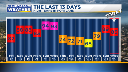
Hasn’t it been nice the past three days?  After the searing mid-summer heat this week has been glorious…definitely a late-summer or early fall feel out there.  Today we made it into the mid 80s after a comfortable morning mainly in the 50s and 60s.

High Temp Last 13 Days

The hot upper-level ridge of high pressure that’s been so persistent since mid-July has moved well offshore, taking the heat with it.   There is a weak upper-level system passing by the next 24 hours; it’ll give us a strong push of marine air tonight.  Expect plenty of cloud cover and even spots of drizzle Thursday morning.

Beyond tomorrow it appears we’ll be in a mild westerly flow through the foreseeable future.   That means comfortable warm temperatures most days and more sunshine than cloud cover.  Of course our Labor Day Weekend is looking good too.  Here’s a peek at the ECMWF ensemble temps for the next two weeks…a stable weather pattern for early September

KPDX_2018082912_eps_min_max_15

Of course we REALLY need a good soaking, but that doesn’t appear to be an option through at least the first week of September.  Salem will break its all-time dry days record tomorrow.  It’ll be the 80th day without measurable rainfall, today was day #79

Dry Spells Salem

Take a look at the ECMWF 24hr precip forecast from the ensembles and you see no support for anything other than sprinkles for at least the next week.  There are hints of some showers around the 8th-10th of the month, but that is quite a way out

KPDX_2018082912_eps24_precip_360

Luckily it was a somewhat wet weekend in the southern Washington and northern Oregon Cascades.  Some spots saw over 1/2″ of rain along the western slopes.  You can see the rise in moisture with the “1000-hour fuels” from the Log Creek RAWS site near Bull Run Lake

Fire Fuel Moisture Oregon

It’s a bit hard to read, but the black line shows decreasing moisture since the showers in mid June.  Then a quick bump up this past weekend brought moisture levels back to average for late August.  Notice last year (in yellow) moisture levels generally dropped through the first few days of September.  Then of course we had that miraculous deluge in the mountains mid-September, ending the fire season early.  We’ll see how it plays out this year.

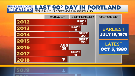
You may be wondering…are we done with 90 degree weather?  Most likely not, although it’s not unheard of to stay below 90 in September.  Here’s a look at the past few years

Mark Last 90 Degree Day Heatwave

The average date is September 8th in Portland.  My guess is that we have another 90 degree day coming at some point next month since temperatures the next 10-14 days will likely run near to above average.

Chief Meteorologist Mark Nelsen


What A Change! Feels Like Fall

August 26, 2018

8pm Sunday

Weather forecast models did a great job showing our “endless summer” was about to…end last week.  Or at least summer will be taking a prolonged break.  Look at the last two weeks and you see the big change Thursday.

High Temp Last 13 Days

That high of 68 in Portland is the coolest day since June 13th.  And that continuously gray sky has been spitting a few light showers or drizzle at times…mainly central & east metro areas.  As of 6pm PDX has only received .01″ (Saturday evening) out of this big change

Rain Metro Today Databound

Of course what we REALLY need is a huge soaking.  It would be nice to see 2″ of rain followed by sunshine and 80 degree weather (personal opinion of course).

This is an incredible number that shows you how dry we’ve been.  The past 4 months…since May 1st.

Mark Dry Spell Summer

Only a little over 1″ of rain in Portland during an entire third of the year!

Mark Dry Spell Summer2

This dry spell (late spring through all of summer) is unprecedented in Portland, Salem, Olympia, & Seattle.  In all these locations it’s never been drier from late spring through the entire summer season.  In most years we get some sort of soaking rains in May, June, or later in August.  But not this year.  Records at Salem go back 126 years!

This is likely killing some native shrubs/bushes and has to be extremely rough on our native trees as well.  Let’s hope for some sort of soaking in September…

The ECMWF model is not encouraging for a soaking.  Here’s the 15 day 24 hour rainfall forecast from all its ensemble members.  Note the showers tonight, then hints of a shower or marine drizzle Thursday.  Af

ter that only a few members show some showers in the first week of the month, but just real light stuff.

KPDX_2018082612_eps24_precip_360

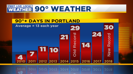
While I was taking a few days off we broke the 90 degree record of course, but other than a close call Tuesday I don’t see any 90 degree weather in sight

90 Degree Days Summer Heat

The ECMWF ensembles shows temperature about as normal as it gets for the last few days of August and early September

KPDX_2018082612_eps_min_max_15

The big pattern change?  Of course we have seen a hot upper-level ridge across much of the western USA through July and August.  Or at least upper-level heights have been higher than normal during this period.  But now it looks more like this:

ecmwf_z500a_noram_4

Higher than normal heights cover the Gulf of Alaska and cooler air is down over the Rockies, a pattern many of us would love to see in January!  Then see the forecast for this Friday:

ecmwf_fri

A similar setup with lower than normal heights over much of the western USA.  Nothing too unusual here; just that the hot ridge and high heights are gone for the next 7-10 days.

So enjoy the early taste of fall…in some years we plunge right into this weather from this point forward.  Other years the heat returns at times in September.  We’ll see.

Chief Meteorologist Mark Nelsen


Thick Smoke = Cooler Today, Back to Hot Tuesday

August 20, 2018

10pm Monday

Fire smoke had no problem moving down into northern Oregon last night and this morning.  In fact it was so thick (shadows barely visible at midday) that we were COOLER instead of WARMER today.  Lower 80s were the rule in the western valleys of Oregon and SW Washington

Todays Observed Highs OrWa 2017

What about tomorrow?  I think temperatures will soar quite a bit higher for two reasons.

  1. We had weak onshore flow today, but pressure gradients are switching now and we’re headed into one day of gusty offshore easterly wind tomorrow.  That alone would raise our temps 5 degrees or more.
  2. There are strong hints from the HRRR smoke modeling that smoke will thin significantly tomorrow afternoon.  That’s due to the strong easterlies bringing clear air from Montana westward all the way to the Cascades and beyond.  Check out the current smoke forecast for right now; widespread thick smoke across all of Oregon and Washington.  Much cleaner air just across the border in Canada.

smoke_8pmtoday

Then the view at 5pm tomorrow after almost 24 hours of easterly flow

smoke_5pm

Look at that punch of cleaner air moving through much of Eastern Washington and right down into NW Oregon.  NASA’S GEOS-5 model shows a similar situation with smoke thinning the next 24 hours.

So the current air quality readings might improve quite a bit in the metro area and Gorge tomorrow afternoon.  At this moment it’s just as bad as we saw during last week’s smoky period

AirQuality Western Oregon

Looking ahead, it’s very obvious we have a sharp turn towards fall-like weather beginning Thursday.  It’s not that we’re suddenly going to turn rainy with highs in the 60s, but there’s no sign of a return to 90s or even 80s through the end of August (just 10 days away).

Check out the ECMWF ensemble chart for 850mb temps for the next two weeks.  Very good agreement that we’re headed into a much cooler period.  The green line is the average temperature at that elevation around 5,000′.  Notice most of the time Thursday and beyond the forecast temp is below that line.  Red is the average of all the ensemble members.  If this is the case, we’re done with the endless warm-hot days of summer and headed into a early fall pattern.

tseries_850t_000-360_Portland (1)

Unfortunately at this point I don’t see a good chance for a big soaking…the ECMWF average rainfall for this entire period is less than 1/2″ of rain.  Still, this weather will put a damper on fire behavior…baby steps toward the approaching wet season.

As for temps, you can see the stark change from Wednesday into Thursday as onshore flow kicks in and temps lower

KPDX_2018082012_eps_min_max_15

I’ll be off the next few days, but back at work Sunday.  Things should look quite a bit different by then.

Chief Meteorologist Mark Nelsen


Hot & Smoky Ahead; Then “Fall” Arrives

August 19, 2018

8am Sunday

I’ve ignored weather maps during my weekend, but this morning I see three highlights while perusing weather maps with my coffee.

1. ONE MORE ROUND OF HOT WEATHER

The first is that we’ve got another brief period of hot weather coming, although once again the heat won’t be too extreme.  We don’t get long heat waves in late August and this will be no different.  Highs reach right around 90-95 or so Monday-Wednesday.  Today should be fine.  Just a bit warmer than yesterday with highs in the mid-upper 80s.  You’ll notice a little more fire smoke than yesterday, and in parts of the metro area the air quality has gone downhill again.  We’ve got weak onshore flow today, keeping those temperatures in check.  Notice the easterly flow on the cross section forecast for Tuesday.   The colored areas are relative humidity above 70%, see how the marine layer disappears Monday PM and Tuesday AM.  “21/12” on the chart refers to 5am Tuesday.  “20/12” is 5am Monday.

kpdx.th

But later Monday and all day Tuesday we get an offshore/easterly flow coming down out of Eastern Washington, through the Gorge, over the Cascades, and into NW Oregon.  That helps things heat up Monday and Tuesday, but brings a problem back…

2. FIRE SMOKE RETURNS

Yuck!  I just checked the HRRR smoke modeling and it shows smoke from all those fires in northern Washington pouring back down over us just like it did last week.  The loop is here:  https://tinyurl.com/hrrrSmokeModel  Here’s the image for right now.

Capture

and then the image for tomorrow morning around 8am…you see the northeast flow has brought the smoke right down over us again.

trc1_t1int_f33

The smoke will be with us Monday-Wednesday (3 days), then a HUGE change is showing up on all models the latter half of the week…looks like FALL!

3. BIG COOL DOWN; AN EARLY TASTE OF FALL

Yes, I know it’s not technically fall but it’s the biggest change we’ve seen since late spring.  All through July/August we’ve had a semi-permanent ridge of high pressure either over us, just to the east, or just to the west/northwest.  Here’s the ECMWF ensemble average of upper-level heights for Wednesday; warmer colors are above average heights and blue are below average

ecm_wed

and then one week from now, Sunday the 26th

ecm_sun

A cool upper-level trough over Western Canada and the Pacific Northwest.  This screams “end of summer weather” for at least 4-5 days starting Thursday.  A thick marine layer Thursday and beyond means you’ll need to get used to lots of morning (or all day) clouds and spots of morning drizzle at times.  High temps will drop at least down into the mid 70s.  This late in the season a thick marine layer with AM drizzle can keep us in the upper 60s too.  Here’s the ECMWF ensemble meteogram for Portland; quite a change eh?

KPDX_2018081900_eps_min_max_15

Looks pretty comfortable!  It’s not like we’re entering a cool & wet period, but the chance for showers definitely goes up at times beyond Thursday, or maybe it’s better to phrase it as “guaranteed dry weather goes away for a few days.  Notice temps do rise slightly beyond Sunday, back to normal which is in the upper 70s the last few days of August.

I’ll be back at work today (I work Sunday-Thursday), forecasting on the 5, 8, 9, 10, & 11pm shows…I shouldn’t be hard to find!

Chief Meteorologist Mark Nelsen


Clean Air Returns & Thunderstorms Tonight Eastside

August 16, 2018

9:40pm Thursday

Today has been refreshing…brief morning clouds and then cooler temps.  We hit 83 in Portland this afternoon; down from 89 yesterday and 90s on Monday and Tuesday.

High Temp Last 13 Days

Most noticeable is the cleaner airmass over us.  Everyone in the metro area is breathing GOOD air quality this evening

Capture

You probably noticed there is still high-level smoke overhead, evidenced by the yellowish sunshine.  Even that goes away Friday as upper-level winds turn westerly for a few days.

We are getting another push of marine air this evening and models show low clouds coming up mainly the Columbia River for a gray start in much of Cowlitz, Clark, and Multnomah counties Friday.  After that you can expect a very BLUE sky overhead since that smoke should be gone.

As expected, thunderstorms have fired up across central and eastern Oregon this evening.  Take a look at the 100+ cloud/ground strikes in the past half hour

KPTV 2017 Default Earth

Many of these are producing very little rain so obviously this is a huge concern for fire starts.  Hopefully new fires remain small.  I saw what appears to be a new fire producing a large smoke plume just southwest of Summer Lake earlier this afternoon on GOES-16 imagery.

What’s ahead?  Typical late August weather…a little heat, but cooler periods as well.  It’s pretty obvious we have passed the worst of summer.  That is normal for us.  Nights are getting longer; giving us cooler nights.  In fact even the middle of the metro area should drop into the mid 50s tonight and tomorrow night.  Nice.

There should be one more brief hot period Sunday-Tuesday, then cooling again later next week.  Notice the good agreement on the ECMWF ensemble chart; a peak around Monday/Tuesday, then quite a dip later next week before more warming.

tseries_850t_000-360_Portland

Down here at ground level that translates to high temps back into the 90s early in the week and then back down around 80 (or below) a week from now.  This is what the same ECMWF model thinks Portland will look like over the next 10+ days

KPDX_2018081612_eps_min_max_15.png

Rain?  Unlikely we’ll see anything other than sprinkles out of marine clouds the next 10 days.  Only 6 out of 51 ensemble members bring .10″ or more to Portland in the next 2 weeks.

KPDX_2018081612_eps24_precip_360

Chief Meteorologist Mark Nelsen


Thick Fire Smoke Is Back; But It Keeps The Heat Away

August 14, 2018

9:30am Tuesday

It’s back! For the first time since last summer’s Eagle Creek Fire,  the Portland metro area is basking in thick low-level fire smoke. This type of smoke with lowered visibility is what SW Oregon has been dealing with for a month!  Here’s a pic from Andrew Mork

photo

Air quality is in the UNHEALTHY category across the Portland metro area and Columbia River Gorge this morning.

Capture

Up until this point we’ve only seen smoke high overhead. Easterly wind has brought smoke from Eastern Washington down into our area. It should clean out quite a bit tomorrow with a switch back to westerly wind. Air quality sensors from Oregon DEQ show UNHEALTHY air over us right now due to those smoke particles. Notice it only extends into the metro area with cleaner air down in the Willamette Valley.

The easterly flow this morning is the strongest we have seen since June.  Wind has been gusting up around 40 mph the past few hours at Crown Point in the western Gorge and Corbett was just about the warmest place in the metro area last night…only briefly dipping into the upper 60s due to mixing from the wind.

The wind goes back to westerly at low levels tomorrow which should clear us out quite a bit, but we’ll still be left with all the high level smoke as we’ve seen the past few days.  Fires are burning north of us in Canada, northern Washington, and to our south in SW Oregon.  It’s hard to get out of the smoke until flow goes westerly at all levels; we’ll likely not get totally out of it until Friday west of the Cascades.  Note the HRRR experimental smoke model forecast for Wednesday afternoon has the entire Pacific Northwest bathed in a smoke layer of some sort.  Click the image for a loop

Capture

The one HUGE benefit is that the smoke layer is going to keep temperatures well below what we would typically see with this airmass.  We have easterly offshore flow plus an 850mb temp of +20 on the morning sounding at Salem.  Models are forecasting +22 by this afternoon.  Under blue skies I would forecast a high of 100 this afternoon.  I think 90-93 is more likely due to the smoke…hot, but nothing crazy hot.

Chief Meteorologist Mark Nelsen