I didn’t take a long vacation, just 5-6 days, but apparently there was some excitement while I was gone. Models (mainly the GFS and for about 2 days) showed a big arctic blast for the first weekend of March. But now we’re back to reality and I’m working again. Here are a few highlights:
1. Friday looks great! Offshore flow on the last day of February with at least partly cloudy skies means 50s and maybe even a few places west of the Cascades around 60.
2. Colder east wind starts blowing tomorrow night and continues through at least Sunday morning. It’s going to be colder and it’ll FEEL a lot colder than Friday.
3. IF we get some sort of frozen precipitation west of the Cascades this weekend (snow, sleet, or freezing rain), it will only be cold enough from late Saturday evening through Sunday morning. Keep in mind that it’s extremely rare to get freezing rain in March in Portland. In fact I haven’t seen it this late in the season in my 22 years of forecasting in Portland.
4. If you live at the Coast, or south of the metro area (Wilsonville south to Eugene), forget about anything frozen…too mild.
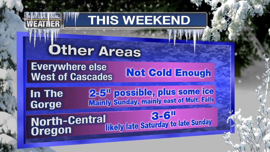
5. If you live in the Gorge, snow or freezing rain could linger until Monday morning. This might be a rare early March ice storm there. I’ve only seen freezing rain once in 22 years of forecasting here in the Columbia River Gorge.
6. My gut feeling? Our forecast models are likely overplaying the cold air that will come down from the north tomorrow night and Saturday and the metro area won’t see anything frozen. Also I feel at this time that it won’t be a “major” snow/ice event in the Gorge, but just unusually late in the season.
I’ve looked at all the 00z models this evening. And after several poor performances by the GFS and WRF-GFS the past few months, I finally broke down today and decided to try the ECMWF products over at WeatherBELL. Quite a bit more detail on those than I get from my data provider. I think it’ll be worth the $180/year…especially if I can get the boss to cover that! Anyway, the ECMWF never went as crazy with the cold air to start with since it showed the upper level low sliding down through Western Canada, then retrograding out to the west as westerly flow returned back over us. Once again, it just does a better job in general than the GFS and apparently that disparity is about to become even more pronounced. Cliff Mass had an excellent blog post this week pointing out the disappointing developments in numerical weather modeling. Basically the ECMWF is going to be getting a resolution increase, thus the GFS will be left even farther behind with no sign of improvement here in the USA.
Tomorrow looks excellent with offshore flow picking up during the day, but no significant advection of cold air from the northeast yet. Hard to believe it’s the last day of February, but mild offshore flow and mostly sunny skies should push us well into the 50s. Assuming cloud cover doesn’t thicken too quickly, some spots will get up around 60.
Then tomorrow night and Saturday models say the cold air from the big arctic high over Alberta surges south into Eastern Washington and is drawn into the Columbia River Gorge. This is where I think models are being too aggressive with the cold air. There’s very little upper-level support. Consider that in each arctic air event this winter (all two), models overdid the initial push of cold air, and they were too fast both times as well. Take a look at the WRF-GFS for 7am Saturday. I find it extremely hard to believe that it’ll be 13 degrees at 2,000′ at the eastern end of the Columbia River Gorge in this setup. That same model shows a HIGH of 34 Saturday…no, it’s unlikely that we’ll even get BELOW 34 Saturday morning since the wind will probably pick up during the night.

I did notice the 00z WRF-GFS is slightly warmer than the 12z GFS from earlier today; only a couple of degrees, but it’s headed in the right direction. Our RPM is especially uneventful for the whole weekend. Note the high of 42 Saturday and mid-upper 40s late Sunday as the milder southerly wind kicks in. Also notice how it’s pretty much dry through Sunday afternoon. But, this model has been a star performer so far this winter:

As a result, my 7 Day forecast didn’t go as cold as some models would suggest; but similar to the ECMWF, showing temps hovering within a few degrees of 40 from late Friday night through Saturday afternoon. Then Saturday night is our chance for snow or freezing rain assuming more moisture shows up than either the WRF-GFS, GFS, or RPM show. The ECMWF was much juicier from later Saturday through early Sunday and I’m trusting that one more.
By Sunday afternoon the cold air is disappearing as a weak southerly flow starts in the valley. And Monday we should actually have a breezy south wind; pushing temps well into the 40s. This is assuming models ARE too aggressive with the cold to start with.
We’ll see tomorrow if models back off on the cold air a bit further or not; another good 24 hours of model riding!
By the way, would you people prodding each other in the comments a couple of days ago knock it off? Again…40+ year old guys acting like its middle school. Amazing.
Chief Meteorologist Mark Nelsen


 Posted by Mark Nelsen


