Vacation Time

February 23, 2013

I’ll be on vacation through Sunday, March 10th.  Probably no new posts during that time; I’m confident you don’t want pictures of me relaxing after the exhausting, crazy winter of 2012-2013.  Wait, I’m thinking of some other winter…instead I’ll be raising a toast to the most boring winter in years.  Let’s put it to rest and move on to spring.

Please behave in the comments below while I am gone.  Note the rules to the right.  I will be checking in from time to time.


Pacific Northwest Weather Workshop

February 21, 2013

It’s the first weekend of March, a week from tomorrow;  the yearly Pacific Northwest Weather Workshop up in Seattle.  I’ve attended this event in the past few years and really enjoy it.  The presentations/papers are all focused on the Pacific Northwest.  Take a look at this year’s agenda here

You can also register at the same site.  Just $30 for two days; $15 if you are a student.  They always have really good cookies too, and it often includes a tour of the NWS Office up there at Sand Point.  I’ll be out of town so I can’t go this year…I’ll have to miss out.

Chief Meteorologist Mark Nelsen


ECMWF Weekly Maps

February 21, 2013

It’s Thursday afternoon, so a fresh run of the ECMWF out to 30 days.  Here are the week-by-week maps.

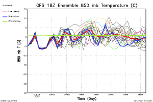
By the way, models have warmed even further with the Saturday and Tuesday troughs, so we have eliminated any “snow in the hills” wording on our 7 Day forecast.  There could be sticking snow briefly Saturday morning as low as 1,000′ in the Coast Range and west slopes of the Cascades, but more likely up around 1,500′.  The 18z GFS doesn’t even have it that cold for Tuesday now and the ECMWF is around -5 to -6 at that time at 850mb.

Here is the 12z ECMWF ensemble chart, followed by the 18z GFS chart:

tseries_850t_000-360_Portland

tseries_850t_000-384_Portland

Now the ECMWF weekly maps:

500za_week1_bg_NA

500za_week2_bg_NA

500za_week3_bg_NA

500za_week4_bg_NA

Chief Meteorologist Mark Nelsen


Winter Is Over In The Lowlands

February 20, 2013

MarkWinter_OverFork

This winter has been the most boring and mild we have seen in about 10 years. By “mild” I mean a lack of extremes and weather action, not the actual temps.  I think the regular commenters on here most likely agree.

Other than some wet and windy systems coming up for the last 8 days of February, I don’t see anything too exciting in the foreseeable future.  Models the past 24 hours have warmed slightly again for this weekend and early next week, enough that I think ANY sticking snow below 1,000′ is unlikely.  I even think it’ll be tough to get sticking snow to 1,000′ in the West Hills early Saturday or late Monday night/Tuesday morning.  That is the last chance this month for lower elevation snow.

So I think it’s time to stick a fork in winter HERE IN THE LOWLANDS WEST OF THE CASCADES, although in reality our winter was probably really over back around the last week of January.  Generally, most real winter weather west of the Cascades occurs between November 15th and February 15th, especially the really cold and snowy/icy storms.

You see the details in the graphic below: 

MarkWinter_Over1

THIS MEANS WE COULD STILL SEE MEASURABLE SNOW IN PORTLAND, BUT IT’S UNLIKELY. 

Most windstorms west of the Cascades tend to occur November-February, but in the past we HAVE seen windstorms in March and October.  But the likelihood goes way down from here on out to spring.

A few questions you may have…

Should I take my studded tires off?  Definitely not if your travel takes you up into the hills or mountains.  In fact it’ll be very snowy in the Coast Range Friday night and Saturday morning.  It sure doesn’t hurt to leave them on for another couple of weeks; but that’s up to you.

Should I uncover my faucets?  Yes, no more significant freezing on the way.  If you didn’t put on your studs this year (like Wayne Garcia), you just saved about $120!

Wait, last year you said winter was over in mid February and then we saw several inches afterwards; why should I believe you now?  Good point, last year I said snow was unlikely below 1,000’…big screwup.  Notice I changed the wording this year to say wet morning snow is still possible (but still unlikely).  All the rest of last year’s “winter cancel post” was just fine.

For the geeks, I see the 00z GFS is around -5 to -6 with onshore flow Saturday morning and again late Monday/Tuesday, then it’s on to milder weather beyond that.  That means it was time to cancel winter.

Chief Meteorologist Mark Nelsen


Snow In Lowlands? Unlikely, But a Slight Chance

February 19, 2013

11pm Tuesday…

Over the past 5 days or so there have been strong hints that several very cold weather systems (for late February) will drop into the Pacific Northwest this weekend and early next week.

Over the past two days models have been very gradually warming up the pattern (slightly).  This may very well be enough to eliminate the possibility of lowland snow.  As of this evening it appears too warm to get snow much below 1,500′ Saturday and Sunday.  We’ll see about Monday-Tuesday next week.  Even that looks very marginal…I’d assign the possibilities these percentages based on current info:

MarkSnow_PortlandOutlookPercentages

Big Picture

We haven’t seen measurable snow this winter and I don’t see a real good chance for measurable snow in the next 7 days.  The chance isn’t gone, but it’s looking slim right now.

Chief Meteorologist Mark Nelsen


Funnel Cloud Over Battle Ground?

February 19, 2013

Sure looks like it to me!  This pic is from John & Roxie in Battle Ground earlier this afternoon…any comments?

MarkPhotoFull_1

Chief Meteorologist Mark Nelsen


ECMWF Weekly Maps & 18z Ensemble Chart

February 18, 2013

We already have the general idea (from the previous post today) that cooler than average temps are on tap for the next 7-9 days. Then the first wet westerly flow we’ve seen in quite a while.

What about beyond that time? That would be maps #2-4 below. This is the monthly run of the ECMWF split into the next 4 weeks. Could we actually have a mild start to March??? Maybe…maybe.

I’ve included the 18z GFS ensemble chart which says after next Monday-Tuesday we’re headed to milder weather. It also shows the operational model is the coldest in the Sunday-Tuesday period too.

500za_week1_bg_NA

500za_week2_bg_NA

500za_week3_bg_NA

500za_week4_bg_NA

tseries_850t_000-384_Portland

I need to get those forks sharpened…