Winter 2019-20: What Are We Seeing?

October 31, 2019

8pm October 31st…

Each fall people ask me “what this winter will be like” or “I’ve heard it’s going to be a bad winter“.  By the way, I’ve NEVER had a person say “I’ve heard it’s going to be an easy winter“.  Apparently most of us are quite cynical and expect the worst.

I don’t put out a “winter forecast”.  That’s because the few forecasts I see are frequently (not always!) wrong and seasonal/climate forecasting has a long way to go before we say we can “forecast” a winter.  So we’ll just call it “my thoughts” for the upcoming winter since we can at least glean a few ideas by looking over some weather tidbits.  I’ve been doing this for a few years and it seems to work.

For those of you with a short attention span, just three points:

  1. Plan on a “regular” winter this year.  There’s no reason to think we’ll be abnormally wet or dry.  Expect that at least once we’ll see some snow or freezing rain in the metro area.  No, we have no idea when that could happen.  Assume that we’ll get a hard freeze (down to 20 or lower) at some point too.
  2. I’d be surprised if we have a bad snow year in the Cascades, but I’d be just as surprised if we had a big snow year.  Gut feeling is we’ll see normal or slightly below normal snowfall.  Go ahead and plan on a normal ski season with the usual variable ski conditions from week to week.
  3. NO ONE is able to forecast a specific event/events weeks or months ahead of time.  If someone tells you (for example) we have 8-10″ snow on the way sometime in February, that’s meteorological click-bait.

Notice there’s nothing earth-shattering weather-wise in those two statements.  That’s because we aren’t seeing a lot of guidance that tilts the forecast one way or another.

Okay, let’s jump into it. First a summary of the past 3 winters:

2018-2019  

Up until around February 3rd, we experienced the most boring winter I can remember in my 28 winters forecasting in the metro area.  Long periods of weak weather systems, almost no real “storms”, and mild temperatures.  This is typical for a weak “El Nino” winter.  That means the tropical Pacific Ocean was a bit warmer than average.  Things were progressing according to plan…

WINTERWXMEET2019

But then all hell broke loose around February 5th.  Cold northerly flow became a common weather theme for much of the following five weeks!  Several snowstorms moved through the region, affecting different parts of the FOX12 viewing area at different times.  Who can forget the “Kale Fiasco” when some metro-area stores ran out of kale & other groceries?  A good learning time for local forecasters…


2017-2018

Two winters back was a “La Nina” winter which means for the 2nd consecutive year the tropical Pacific Ocean was cooler than average.  For meteorologists (and you) it was a relatively “slow” winter; warmer & drier than average.  We had a brief snow/ice event at Christmas and then one fun week in late February with snow.  But that was it.

Winter_2017_18 Recap

2016-2017  This was the first “La Nina” winter; it was crazy, wild, & cold. There were numerous ice & snow storms in the Portland metro area, Gorge, & Eastern Oregon.

Winter_2016_17 Recap


As I mention above, there is still a LOT we don’t know about our climate and seasonal shifts in our weather.   It’s hard to believe, but this will be my 29th winter forecasting here in NW Oregon (started forecasting professionally off-air in October 1991).

Typically we focus on the La Nina/El Nino oscillation across the tropical Pacific and what that means for Northern Hemisphere winters.  That is still the case, but a few other factors are likely playing into our winters including this one…a weakening polar vortex:  https://www.eurekalert.org/pub_releases/2017-09/pifc-wce092217.php. That research, published just a year ago, suggests there have been increasing outbreaks of cold polar air farther south as the arctic warms.  Interesting eh?  Of course down here in the Pacific Northwest the issue is WHERE the cold air dumps south.  For example, that first La Nina winter (above) we had cold air come down to our east quite frequently (a frozen Eastern Oregon).  Then during the 2nd La Nina winter something was different and for some reason the cold air stayed farther east.  We had a warmer/drier winter during a La Nina year!  This past winter, during an El Nino event, we saw that highly amplified cold northerly flow with a strong ridge of high pressure offshore.  But it was only during the last few weeks of winter leading into early March.  Most surprising to me is that the pattern lingered for so long.  So each winter is different and lots more research is needed.

At this point NOAA is expecting this to be a “neutral” winter; most likely on the “warm side” bordering a weak El Nino event.  So we don’t have solid La Nina event in the Pacific this winter, not a solid El Nino either.  Just in-between or it could end up a very weak El Nino

Capture

Of course this sure doesn’t help the outlook much does it?  One more reason not to make a “winter forecast”!

What everyone really wants to know is…will it snow at MY house this winter???

For fun, I looked at all 21 “ENSO Neutral” winters since 1950.   There have only been 4 in the past 20 years, most recently in 2013-14.  In 2/3rds of these winters, we’ve picked up at least 1″ of snow in Portland at some point during the winter.  Two of the past four have featured some sort of snow storm (several inches at one time).  That was in 2012-13 & 2003-04.  But we’ve been hosed some of these years as well.

To summarize: Flip the dice, I don’t see anything that screams there WILL be snow or WON’T be snow this winter.  There’s a decent chance we see white at some point though, even if it’s just an inch or two.

By the way, here’s a national look at those ENSO neutral years temperature-wise.  Interesting cold signal for most of the nation but not here.

ensoneutraltemps

Then the precipitation compared to the long term average for those winters.  These types of winters have tended to be drier than average in California, but wetter in Washington.  That doesn’t tell us much if we live a few miles from the Columbia River!  Right on the line between wetter and drier.

ensoneutralprecip

SKIING & MOUNTAIN SNOWPACK

It’s time to get your season pass!

No, no one has instructed me to send that message out, and no one promised me free skiing if I put that message on this page.  Of course it IS the time of year to get your pass; one reason for the attention-grabbing blue.  Prices tend to jump sometime after Halloween, exact dates depend on the resort. More important…

We probably have a relatively normal snow year in the Cascades on tap for 2019-2020.

Why do I think that’s the case?

  1. All ENSO neutral winters have given us abundant snowfall at the Cascade ski resorts.  Some years well above normal, some a bit below.  At both Government Camp and Mt. Hood Meadows (two snow-measuring locations) this is the case.
  2. Only one of the worst ski seasons have been during neutral winters.  The terrible years that many of us remember (1976-77, 1991-92, 2004-05, 2014-15) are not on the “neutral” list.  That said, there was one…1980-81 was pretty bad.  Only 60″ fell at Government Camp from December-February

Take a look at Cascade snowfall during the 21 ENSO neutral winters we have seen since the early 1950s at Government Camp.  Average yearly accumulation (for any year) is 260″ (click for full-size)

govysnow

Obviously each winter is quite different, but the average for these neutral years is just a bit lower than the long-term average.

Now I’ll throw in Mt. Hood Meadows (in red)

Capture

Same idea, no disastrous winters, but quite a bit of up/down each year.  Near normal for neutral winters.

I know it has been a long read, but hopefully you have a little better feeling for what we might see during this upcoming winter.

Chief Meteorologist Mark Nelsen


A Cold & Breezy Tuesday

October 29, 2019

10am Tuesday…

Everything proceeded according to plan last night as a very cold (for October) and dry airmass blasted through the Pacific Northwest.   This morning it’s cold and windy across the entire region.  In Portland the air temperature is 37, and the wind is gusting to around 40 mph.  Wind chill temps (what it feels like when you combine wind + temperature) are in the 20s in Portland!  You aren’t crazy, the morning commute really did feel the same as December or January.

web_windchill_metro

What’s ahead?

  • Gusty east wind will continue today across the metro area and many other locations.  Not much damage because speeds will generally stay below 40 mph.  Just expect a few more limbs over powerlines and lots of leaves blowing aroudn. The wind dies down tonight away from the Gorge.
  • Temperatures slowly crawl towards 50 degrees.  If we stay under that 50 degree mark, it’ll be our coldest October day in 16 years.  Quite an impressively cold airmass considering it’ll be sunny all day!
  • Windchill will be an issue through the evening commute, not dangerous but annoying.
  • Areas that go calm tonight will see lows between 18-25 degrees west of the Cascades.  Windy areas stay in the 30s east metro and in western Gorge windy locations.
  • Wednesday turns a little warmer with wind confined to the usual east wind spots in metro area.


The “arctic front” passage was one of the best I’ve seen in my decades of forecasting here; both east and west of the Cascades.  A sharp shift in wind direction, big drop in dewpoints, and sudden increase in speed.  Plus it moved very quickly and didn’t linger. The Dalles gusted to 40 mph…from the east.  Very unusual.  It arrived suddenly at my home just as I was parking the car after work.  At PDX, the wind coming down off the Cascades arrived suddenly around 12:30am.  Models did a spectacular job (this time) portraying the sequence of meteorological events.  The midnight to 2am arrival time in metro area was right on.

Peak gusts have generally been in the 25-45 mph range, right on target as well.  The highest gust in the metro area is 50 mph on the I-205 Glen Jackson Bridge.  PDX is close behind with a 45 mph gust (click for a better view)

Capture

This is the coldest October airmass in our area since 2003.  Keep in mind the current metro temps are “well-mixed”, meaning this isn’t just the usual surface nighttime cooling.  It only gets colder as you go up.  If precipitation suddenly arrived over us, it would snow down to sea-level.  This is how we would get late October snow or freezing rain.  But no clouds or precip anywhere nearby so we are clear.

web_metrotemps

The mountains are frigid this morning; temps in the teens and windchills to zero or below.  Winter in October, but bright and sunny.

Current Conditions Mt Hood Temps with ODOT Cam

Because the wind hasn’t been TOO strong, I see there aren’t too many power outages.  Under 2,000 PGE customers out at 10am.  During the November 2014 downslope windstorm many tens of thousands lost power.  This one is quite a bit weaker.

Stay warm today!  See you at 4pm on FOX12 OREGON.

Chief Meteorologist Mark Nelsen


Sunny Days, But Cold & Windy Weather Ahead

October 27, 2019

7pm Sunday…

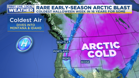
I can’t find any rain for the FOX12 viewing area in the next week.  And almost EVERY DAY will be sunny.  But hang on, there’s a big catch; Monday night & Tuesday will be very windy and chilly for the entire metro area.  In some parts of the Pacific Northwest this will be a historic cold snap for so early in the cold season.

First, today was a fantastic late October day; brief spots of fog and then all sunshine.  High temps right around 60 are normal for this date.  Although the low of 33 was much cooler than average

Todays Observed Highs OrWa 2017

October continues to be the coldest in Portland since 1969.

30 Day Almanac - CSV Driven

I was 6 months old last time we saw an October this chilly in Portland…let that sink in.  And now it appears the last three days of the month (not tomorrow) will be unusually cold for late October, especially east of the Cascades.  In fact the airmass coming out of Canada will be the coldest we’ve seen around Halloween since 2003!

THE HIGHLIGHTS

  • Expect mainly sunny skies through at least next Sunday.
  • Monday will be nice again, just like today.  Comfortable temps and light wind
  • Around midnight or so tomorrow night, a strong east wind develops over the Cascades and comes down into the foothills.  Strong and/or damaging wind is POSSIBLE in a few isolated spots.   Where gusts exceed 40 mph is a tough call.  Could be eastern Clark county, eastern Clackamas or Marion/Linn counties.   I mention 40 mph gusts because in these areas a strong east wind doesn’t happen very often.
  • After midnight (early Tuesday) that wind will descend into parts of the metro area too.  At sunset tomorrow it’ll be calm in Portland, but for many areas the wind will just suddenly pick up at some point during the night.  Probably a few limbs will fall onto power lines and give us a few outages.  Gusts 35-50 mph are possible.  Everyone gets SOME easterly wind, but only a few spots get gusts over 40.
  • Tuesday will be sunny, windy, & chilly across the region.  Portland metro temps only top out around 50 degrees; not record cold, but close.
  • Cold air across eastern Oregon will be some of the earliest you’ve ever seen along with a gusty north wind.  Very cold in Cascades too; Timberline goes from around 40 tomorrow to 15-20 (high temp) Tuesday!  Expect easterly gusts 40-50 mph up there too.  Hiking in Cascades Tuesday will be just like wintertime; without snow on the ground of course.
  • Wednesday the east wind returns to the usual spots in the western Gorge and east metro.  All other areas will calm down wind-wise.
  • Calming conditions Wednesday-Friday mean the coldest outlying areas west of the Cascades could reach 18-25 degrees for lows.  We haven’t seen this in late October since 2003.

Where is this coming from?  Northern Canada, way up in Northwest Territories.

Mark Jet Arctic 850mb Temps1

By Tuesday morning, that lobe of a cold upper-level low over Canada will be right over Idaho

Mark Jet Arctic 850mb Temps2

How cold?  850 millibar temps on Tuesday morning are forecast down to around -12 over Spokane.  So around 4,000′ elevation it should be about 10-12 degrees F!  That same airmass pushes up against east slopes of the Cascades.  That means Timberline Lodge and Mt. Hood Meadows, plus the upper parts of Skibowl will be somewhere between 10-15 degrees Tuesday morning and struggle to get above 20 by afternoon!  That’s midwinter cold.  Speaking of records, Spokane has not seen anything colder than -12 (at 850mb) before November 10th, so this is the earliest it gets there.  At Boise, the sounding each day has never been lower than -8 (at 850mb) before November 12th.  Models are forecasting around -11 Tuesday morning there, a full two weeks earlier then the previous record!  So this is historic cold over the inland Northwest and Rockies.

Notice we are right on the edge of the cold air, so the main effect will be strong east wind for one day (Tuesday) all areas and then a continuing east wind Wednesday closer to the Gorge as upper-level temps warm dramatically through Thursday.  Dewpoints will be dropping below 10 degrees west of the Cascades.  Think dry desert air that cools quickly at night.  Calm areas that get up around 50 during the day will drop into the low-mid 20s Wednesday morning.  I think the coldest spots west of the Cascades will be in the 16-20 range at some point Wednesday-Friday mornings.

Last time this happened was in 2003; yes, I actually saved this map from 16 years ago.  Weird, I know.

October2003Map

The trough was a little farther west and stayed over us longer compared to what is forecast this week.  PDX saw five days with highs below 50 degrees starting on Halloween that year.  We ended up with a low of 26 from that cold spell.

Then one year previous (late October 2002) a similar setup brought record cold to our region.  I have it in my notes that it was the “coldest airmass of the season”.  That was a very mild winter, but I’m not sure if I was referring to the general setup or if it really was the coldest airmass to come south.  Regardless, look at those low temps on this slide I presented at a winter weather recap the following year:

October2002Stats

That 2002 event was more like this one; cold air comes in quickly and leaves quickly in a couple days.  Notice it set October lows for several stations.  In Portland we’ll have to drop to 25 to set a new October low.  There’s no reason that couldn’t happen if wind goes calm at PDX at some point Wednesday night.  We’ll see.

Enjoy the sunshine Monday, but be ready for a big chill and lots of flying leaves Tuesday!

Chief Meteorologist Mark Nelsen


October Will End Unusually Dry

October 23, 2019

6pm Wednesday…

Today was a great late October day; early fog/clouds then afternoon sunshine.  Temperatures peaked out around 60 in the metro area, perfectly normal for October 23rd.

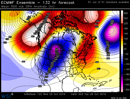
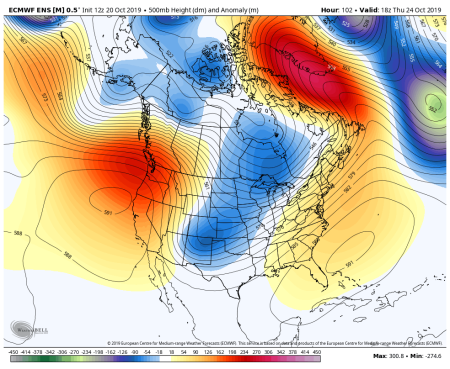
Looking at all the maps/charts/models this afternoon, the most obvious feature is a persistent upper-level ridge near the West Coast of North America for at least the next 7-10 days.  One weak weather system slides through the ridge Friday for clouds and a few sprinkles/shower, but that’s about it.  Take a look at the current pattern at 500 millibars (around 18,000′)

Mark Jet Stream

Behind that weak system, the ridge pops up again but farther west.  This gives us cool northerly flow again; like we have seen twice so far this fall season.  Although this time the core of cold air is farther east.  The view Saturday…

Mark Jet Stream2

This setup in the cool season (we’re just about there) typically features very dry air coming down from the north or east.  Low relative humidity = not much cloud cover or valley fog.  So this weekend will feature abundant sunshine and a “cool-ish” feel.  That’s perfect pumpkin patch weather.  Our wet ground will be drying out nicely.

That ridge is probably going to remain near or just west of the West Coast through next week.   And it’s quite a block in the atmosphere.  Look at the high/warm anomalies stretching north to the Arctic Monday afternoon (red/pink colors).  On the backside see those low/cold anomalies from Hudson Bay all the way down to Baja California!

eurmon29th

Jumping ahead to NEXT Friday (the 1st), the ridge is still there.  Maybe a bit farther west

eurfri1st

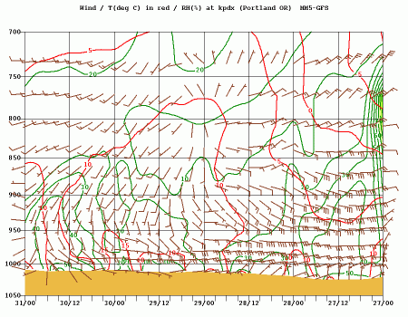
These last two images are from the EPS (ECMWF ensembles), but other models are similar.  The screaming message here is that we’re going to be quite dry for the next 10 days.  We’ll probably see a gusty east wind develop after Saturday as well.  That plus dry air should keep fog to a minimum.  Take a look at the WRF-GFS cross-section that covers Saturday afternoon (right side) to next Wednesday afternoon.  Lots of easterly flow, especially early in the period.

kpdx.x.th

This will be our first drier than average October in 6 years.

October Rain Stats

It’s interesting that during the Autumn of 2013 we saw a similar rainfall setup; a very wet September then a dry October.  That also happens to be the last time we were in ENSO-neutral conditions leading into the winter.  That refers to no El Nino or La Nina in the tropical Pacific.   Speaking of…I’m working on some winter thoughts this evening.  I should be able to get a post done for that by early next week.

Enjoy this last weekend of October!

Chief Meteorologist Mark Nelsen


The Week Ahead: Not much rain plus some warm sunshine

October 20, 2019

7pm Sunday…

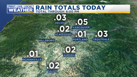
Today was sure a gloomy day!  It seems like it rained at least a third of the day, but we only ended up with a few hundredths of an inch in the metro area.  That’s a classic warm-front setup

Rain Metro Today Databound

The system changed snow to rain in the Cascades.  After a big dumping above 5,000′ Thursday night through Saturday, now it’ll be mainly rain through Tuesday up there.

Snow Mt Hood Totals

A warm but “flat” upper-level ridge is sitting over the NE Pacific Ocean.

Satellite Surface

That gives us lots of clouds, but not much rain.  Tomorrow another warm front sweeps mainly into Washington.  So we’ll see lots of clouds again but little rain.  On Tuesday a little “wiggle” moves over the top of the ridging and down over us.  At that point we should see at least a few hours of rain.  Then the ridge pops up again a bit stronger and closer to us.  Here’s Thursday, look at those 588 dm heights over Oregon!  ecmwf-namer-z500_anom-1940000

If it was early September we’d see 90s out of this pattern.  Instead, at the end of October, highs somewhere between 65-70 are more likely under dry offshore flow.   This means Wednesday and Thursday feature the best and warmest weather this week.

Then by this weekend the ridge pops up a bit farther west, allowing a cold upper-level trough to drop south out of Canada and into the western USA.  That looks chilly!

ecmwf-namer-z500_anom-2177600

These maps are the ECMWF ensemble forecasts, but other models are similar.  Notice the real cold air doesn’t drop right over us, but a bit farther east.  The Rockies and Intermountain region get nailed with cold snow showers next weekend.  This should give us a round of dry/chilly northerly/easterly wind Saturday through sometime early NEXT week.    The result for our area will be a sharp drop in temperatures between Thursday and Saturday/Sunday.  Overnight lows will go from near 50 Wednesday to around freezing once again next weekend.  But not a whole lot of rain.  Check out the change in airmass on the ECMWF 850mb ensemble chart, quite a drop isn’t it?  Just 5 days ago there was not hint this would occur.  That ECMWF wanted to put the ridge right over the top of us, but now wants to dump come cold air south over the West.  This is the 3rd time this fall season we’ve seen this happen.  Very interesting…

tseries_850t_000-360_Portland

Check out the ensemble runs from ECMWF, GFS, & GEM models.  All show 1″ or less rainfall in the Willamette Valley through these next two work weeks.  That’s through the first day or so of November.

This slideshow requires JavaScript.

It’s probably a bit premature to mention this, but why not…  It’s interesting that this is the type of pattern we can get during a weak El Nino winter.  Split flow can be common in those winters too.  We are on the warm side of ENSO neutral right now and it seems we’ll be right on the edge of weak El Nino conditions this year.  Just tossing that out there for fun.

Summary

  • I don’t see much soaking rain for these last 10 days of October, but it will rain here and there.
  • This work week features mild temps, Wednesday & Thursday should be the warmest!
  • Next weekend may feature a nice chill; perfect for the weekend leading to Halloween.
  • There’s absolutely no sign of a stormy weather pattern ahead.  I’m referring to our usual stormy setup with one area of low pressure after another giving us waves of strong wind and rain.
  • Snow in the Cascades will gradually melt over the upcoming week.  A few more inches could fall later Friday or Saturday.

Chief Meteorologist Mark Nelsen


A Week of Wet Weather Ahead

October 15, 2019

7pm Tuesday…

Hopefully you’ve paid close attention to our forecasts the past few days.  If so, you’ve finished up any project that requires dry weather and are now ready for a week of rain.  No, it’s not going to rain for the next 168 hours non-stop.  Instead, we’ll see a succession of wet Pacific weather systems moving into the Pacific Northwest.

After a very wet September, the faucet has shut off this first half of October.  We’ve seen little/no rain the past 10 days in the Portland metro area

Rain PDX Last 10 Days

And of course it’s been a very cool 1st half of October; temperatures are running 5 degrees below average at PDX so far… THIS HAS BEEN THE COLDEST 1ST HALF OF OCTOBER IN PORTLAND IN MY LIFETIME!  Only two have started colder, October 1968 and October 1949.  Those were followed by some interesting winters…just throwing that out there.  I highly doubt what happens the first two weeks of October means anything about the upcoming winter.  Notice the last few Octobers have been wetter than average

October Rain Stats

A cool upper-level trough (dip in the jet stream) is sitting in the Eastern Pacific and moves a bit closer tomorrow

ecmwf-nw-z500_speed-1248800

Tonight a weather system is sitting offshore; it’ll move inland Wednesday morning.  That system will be quickly overtaken by a cold front by tomorrow afternoon.  So we get two waves of rain tomorrow.  Behind that cold front, Thursday and Friday will feature the usual cold showers mixed with sunbreaks.  Friday night and Saturday a quick-moving trough spins up a surface low pressure system offshore.  Models are showing quite a slug of rain and gusty southerly wind with this one.

ecmwf-nw-z500_speed-1486400

That said, I don’t see any hints that we’re entering a real stormy pattern with multiple areas of deep low pressure tracking along the coastline.  We’re just going to see a parade of wet and breezy  systems moving overhead.  In October, in this pattern, it’s possible to get those waterspouts or weak tornadoes too if the pattern is just right.  We’ll be on the lookout for that.

Now that you’ve finished planting your spring bulbs, garlic, or cover crops, you’re probably wondering how much rain is on the way?  Quite a bit!  The WRF-GFS from UW shows less than 2.50″ in the western valleys ending next Tuesday

pcpt.180.0000

ECMWF, GFS, & GEM models all show somewhere between 1.50″ and 3.00″ in the western valleys of Oregon and SW Washington.   Maybe 5-10″ wettest parts of Cascades and Coast Range.  This isn’t enough to cause flooding when spread out over a week, but it’ll help recharge groundwater I suppose

This slideshow requires JavaScript.

This is the reason that I’ve been saying to “wrap up all your dry weather projects” by tonight.  It’s going to be quite wet over this upcoming week.

What about more dry days?  Models are suggesting we get some sort of upper-level ridging over the USA West Coast starting a week from now.  All three of the above models show a strong ridge right over us 8-10 days out.  Here’s Friday the 25th

This slideshow requires JavaScript.

It’ll be interesting to see if we get a setup we’ve seen twice this autumn; a trough suddenly comes across the ridge, pushing it back to the west and putting us under cold northerly flow.  There are a few hints of that in the 12z ECMWF ensemble chart; some ensemble members take quite a dip in the 2nd week.

tseries_850t_000-360_Portland (2)

To wrap it up…enjoy your inside time this next week.  And enjoy the gentle Pacific Northwest rains splashing on your roof.

Chief Meteorologist Mark Nelsen


Coldest October Start in Almost 50 Years; But Mainly Dry Weekend Ahead

October 10, 2019

9:00pm Thursday…

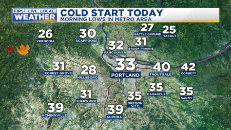
These first 10 days of October have been the coldest in Portland since the early 1970s!  Not only did we see a record low temperature of 33 in Portland this morning; but it was the earliest 33 degree reading since 1985!  Take a look at some of the lows around the metro area

PDX Observed Low Today

You’ll notice that some of us did not have a “first frost”.  Much of East Portland saw enough of an easterly breeze to keep temperatures up around 40 degrees.  A northerly breeze kept some Willamette Valley locations a bit on the “warm” side as well.  Now check out the frigid temps east of the Cascades…amazing for early October.  Single digits at Burns.

Todays Observed Lows OrWa 2017

That 13 at La Grande is the coldest October temp in 13 years!  And it happened by the 10th of the month.  The last time Redmond was this cold (13) in the first half of October was 50 years ago!  Redmond has been all the way down to zero and even a little below in October, but it has always been in the last few days of the month.  This was a very rare event, and I think it’s VERY interesting that we’ve seen something similar occur twice now this fall.  The same weather setup a month from now would give us a blast of cold arctic air.

What’s ahead?  More of the same tomorrow, except a stronger east wind blowing through the west end of the Columbia River Gorge and east metro area.  Gusts have been in the 40-50 mph rage.  Expect those gusts to bump up to around 50-60 there tomorrow and 25-35 mph in east metro.  Of course we’ll see sunshine all day too.

This Weekend

Definitely a “meh” weekend ahead.  A very weak system dies overhead late Saturday and Sunday.  Lots of clouds but very little rain.  We lose the east wind Saturday.  At best we could see .10″ rainfall total by late Sunday.  Monday looks dry too.

There are strong hints that we’ll see our first soaking rain of October the 2nd half of next week.  See the ECMWF model forecast of 24 hour rainfall.  Each thin horizontal line is one of the 51 ensemble members on the top half.  The bottom half shows the average of all ensemble members.  Good agreement that next Wednesday-Saturday will be wet, maybe not excessively so, but back to normal.  Expect lots more cloud cover too.

ecmwf-KPDX-indiv_qpf_24-0708800

All the more reason to enjoy this fantastic sunny/cool October weather.  Have a great weekend!

Chief Meteorologist Mark Nelsen