What a spectacular run of February weather! It’s been 20 years since we’ve seen so many 60+ days in Portland. We hit 60 again today in Portland and with the very dry air mass it was crystal clear. This was the 7th day at/above 60 degrees this month; the most since February 1995. We’re in a “Central Oregon” climate for a few days with the low dewpoints, clear air, and chilly nights. That will end after tomorrow. By the way, we did a story on people suffering from allergies early this year. Most likely the allergens are “ahead of schedule” along with our temps. Notice it’s been warmer than normal for 3 months now:

We finally have some snow on the way for the Cascades…The last time we saw significant snow at Government Camp (more than an inch or so) was two months ago! Only 2″ has fallen there since January 1st. Here’s our forecast for the next 8 days.

Your next question is likely “…Hey, I thought we were entering a period of snowy mountain weather and rainy valleys?“. Well, things have changed a bit in the past week since I posted those monthly ECMWF ensemble maps last Monday.
Instead of the big upper-level ridge pushing well off to the west, models have gradually decided to keep it much closer to us. In a position quite close to where it was much of November. Compare these two images. ECMWF run a week ago for March 2nd-9th (next week):

That was a “Week 3” forecast. Now look at the current “Week 2” forecast, same time period:

The cool and wet trough is gone. With the ridge much closer we just get some disturbances sliding down the coastline this Wednesday/Thursday and maybe another next Monday/Tuesday. That’s it.
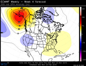
Now take a look at “Week 4” from last week, followed by the new “Week 3” this week. Both are valid for March 9th-16th:


Much different, a weaker ridge off to the west, but the cold trough is gone on this latest run. A bad sign if we want to build snowpack in the Cascades.
March has been the catch-up month for Cascade snow in most of the really bad years. If it doesn’t change this month then it’s too late to have a recovery in the elevations below 5,000′ in the Cascades. Take a look at 3 different SNOTEL sites at Red Hill (north of Mt. Hood), Mud Ridge (near Gov’t Camp), and McKenzie (McKenzie Pass).


Thick blue line is current SWE (snow water equivalent on the ground) and light blue is the average. These are all in the 4,000-5,500′ elevation. All have little or nothing on the ground right now. In an average winter/spring they max out in depth between late February and April 1st because rising spring temps and melting periods at these elevations are able to balance out the snowy periods. Obviously in April then there is more melting than accumulation and the snow pack melts rapidly (in a normal year).
I know I’m making a bit of a leap here, but these maps imply the closed ski areas may NOT be able to open in the first half of March. They need a good 3 feet of snow since they are starting from zero again. And a week or so after that it’s mainly over for the lower elevation ski areas even in a normal year. Most skiers lose interest after spring break because it’s…well…spring. Yes, I know hard-core skiers continue in April or May, but most others move on to spring activities.
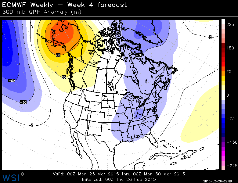
Here is Week 4 of the latest ECMWF monthly run (from last night):
There we go…just when Oregon’s Spring Break arrives, supposedly a cool trough centered just to our south. Actually the ridge is still to our northwest with no sign of a wet westerly flow coming at us. This could just be a slightly wetter pattern.
Just in, the 00z GFS is even more pitiful, showing ridging popping back up over us around days 8-13 and less than 1″ precipitation in the next 13 days!
Chief Meteorologist Mark Nelsen


 Posted by Mark Nelsen


