11pm Wednesday…
Whew, a busy day for the news folks. That means not much focus on the weather despite record highs at Salem and Roseburg.

Here in Portland there was just enough easterly flow to keep us “cool” at 54 degrees…two degrees below the record for the date. Note that the 47 degree low “today” (calendar day) is the warmest low temperature since early January. We haven’t seen frost in almost 3 weeks here in the city either. A very mild 2nd half of January for sure after a nice and chilly start!
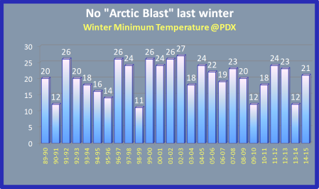
That brings up the question people often ask me this time of year (when temps start to warm). “Has the coldest weather of winter passed on by?“. I think that’s quite possible this year. First, we’ve dropped to 24 at PDX twice in late November. Then and again in early January the colder suburbs dropped into the upper teens. Compare that with the past few years:

If we only have a low of 24 that’ll be a bit on the warm side, although not too unusual. Look at the low temperatures over the past 20 years. The title refers to last winter, although it may end up being correct for this winter too.
Take a look at a neat graphic from Climate Matters, showing the average date of the coldest winter temperature

We already know our coldest winter temperatures are often in late December, but you can see here it tends to be later in the winter in the Eastern USA, especially in the northern areas. That’s because widespread mid/late winter snow cover reflects the sunlight well over there. A wide open path for arctic airmasses to move south over the snow-covered terrain doesn’t hurt either.
The last two big El Ninos featured mild January/February weather so I think it’s UNLIKELY we have anything colder than 24 in the next 5-6 weeks. Of course we know it’s POSSIBLE this late, but it seems unlikely this year.
Chief Meteorologist Mark Nelsen

Yay…Mark dedicated a blog post to one of my favorite topics of all!!! 😀
Anyway….I’m still convinced that weak-sun inversion mechanisms west of the Rockies, between November and early February, play a key role in moving up the coldest average date of winter a bit. Part of it is undoubtedly the fact that, like you said, the same latitudes east of the Rockies tend to have more snow cover, and that this would tend to delay the peak of winter. So does the fact that the “epicenter” of North American arctic air action, seems to nudge slightly eastward after Groundhog Day. (In other words, it’s rarer to see the proper upper-level pattern for arctic air over the PNW in late February and early March, than it is in December.)
But think about how much of a role the Columbia Basin plays in first collecting the cold air, then shooting it down the Gorge. Weak-sun inversions (and sometimes snow cover) play a key role in keeping the east-side lowlands cold for days on end even after the upper-level cold airmass has moved out. It also keeps surface high pressure in place over there, bringing the cold Gorge influence to Portland and much of NW Oregon when the next system comes in from the Pacific!
What happens when arctic air actually does make it in here after Valentine’s Day? As soon as the middle atmosphere moderates, surface temps east of the Cascades also begin to moderate, especially in the daytime. And the powerful solar radiation beating down serves to kill the chill even further, if you happen to be standing in it. (The only exception I ever remember happening was late February 1993, when snow cover east of the Columbia Basin allowed a persistent low-level cold airmass to establish itself a bit later in the season than it otherwise could have.)
Add to this the fact that “fake cold” is a problem under a really warm ridge in November, but almost never in late February, due to the stronger sun angle. Same inversion mechanism as an arctic blast, and once again: it tends to push the low-level cold stuff closer to the winter solstice.
edit: “late February 1993 when snow cover IN the Columbia Basin”
I came upon a really great website last night http://www.oregonphotos.com Apparently created by photographer Bruce B. Johnson. Click or tap “Wildeness Info” then “Oregon and Washington Climate…” Loaded with fun weather and weather related information and pictures! Retired State Climo George Taylor is in there too. A bunch more other relsted links. Great site.
I had been studying up on Burns, Oregon. In spite of the dubious news out of there lately, their climate backdrop has also been exposed. Much more extreme over there than even places like Bend. The town of Seneca is 45 miles to the north. The state record low was recoded there at -54′.
Enjoy!
Just glanced there and found some cameras I didn’t have.
Will be fun to explore, thanks!
62 yesterday in Milwaukie. Low last night of 51 just after midnight, up to 56 this morning. 0.42″ in the bucket so far today, and still raining hard.
Glad I’m not down in Pacific City this morning. 83 degrees and pouring rain, DP of 75F and winds gusting to 45 mph… That sounds absolutely miserable! lol
Get those forks ready!
Mine are ready!
Forks?
Forks.
1.57″ from the atmospheric river so far here.
Sunny and a balmy 57 in PDX. I’m not complaining, but this is what I mean by saying El Nino is knocking the daylights out of these fronts. As they split, of course, they have to go somewhere. That somewhere is apparantly into northern Washington and northern California. So, knocking the daylights out of these for us in Oregon.
A nice break to sunny skies for about an hour and a half early this afternoon allowed the temperature here to climb to 55F- the highest I’ve seen it since early December. After last night’s rainfall it seems we’ll probably have about a normal amount of precipitation for January; somewhere just under 7.5 inches.
Easterly flow still going at PDX. 46 there. 53 here in Battle Ground. It shot up to 57 this morning with the pick up in the winds.
63 in Newberg. 53 at the summit of highway 6 at 8am. Thick fog to go with it.