You are living through what will likely be the hottest summer ever recorded in Portland.
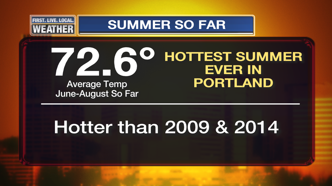
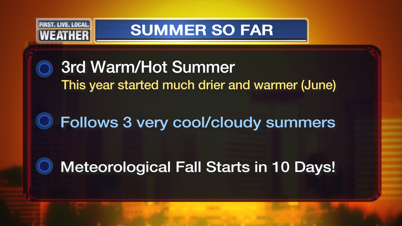
Meteorological summer only has 10 days left (June-August). As of now we’re running almost 3 degrees WARMER than the next closest contender (2009)! In fact we would need to have an average high around 72 and low each night around 50 for the next 10 days to cool our average temperature down to 2009 levels. So…
2015 is going to end up as the hottest summer we’ve ever seen
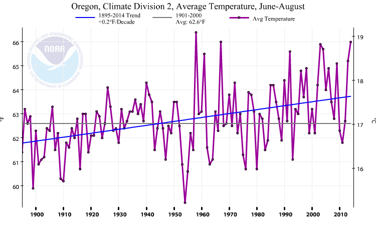
Airport records go back to 1940; and downtown numbers go back to the late 1800s. But the downtown observation was moved around quite a bit, including up high on roofs (not a good idea), so I don’t put a lot of faith in those earlier numbers in the summertime. You can get a general idea if any other summers have been close by looking at the entire Climate Zone #2 here in Oregon; that’s all lower elevation locations between the Coast Range and Cascades. Check out the NCDC data back over 100 years…the June-August average temperature:
Several things stick out:
- Before 1958 there are no obvious contenders for really hot summers like we have now.
- 1958 is a close call but likely cooler than this year. Here in Portland, Summer 1958 was hot but nothing like this year.
- As I mentioned in a blog post last September, our summers are definitely turning warmer. Just since my teenage years (1980s), our summer weather has been warming about 0.5 degree per decade. That’s 5 degrees/century IF that pace were to keep up! Obviously 35 years is a relatively short time period so you have to be careful.
Now before you get too excited about some sort of cataclysmic oven about to descend on the Pacific Northwest in the next few summers, take a look backward first. Remember these 3 warm, then hot, summers follow 3 very cool and cloudy summers. Remember how many of us (including me) wondered if this was some sort of change in our climate? I even constructed a (small) greenhouse for growing tomatoes at my home since the garden was a part failure for two of those years. Now it’s payback time.
We’ve seen a highly anomalous (unusual) pattern of high pressure lingering near/offshore the West Coast. As regular readers of this blog know, this has been going on for 2+ years. That includes the warm blob of ocean water offshore. There is no reason to believe this is a “new normal” and no current research to suggest that.
So no, this is not the beginning of a sudden change caused by global warming and one should not make a (big) leap to a conclusion that all our future summers will be just like this one. That said, there is a clear upward trend in that chart above. With more warming anticipated globally over the next few decades, most likely there fewer very low dips in that chart and more high spots. We’d better learn to adapt!
Chief Meteorologist Mark Nelsen

Time for the coldest winter ever in Portland!!
Mark I must disagree with part of what you posted. While 2010 and 2010 were cooler and wetter than normal 2012 was not. June of 2012 was a little cooler than normal However July through September of that year was warmer than normal. Albeit not like the last three years. 2012 was a transition year to the warmer and drier regime that we have now. I do agree with the rest of it however. In the past we have had a hot year here and there but not year after year after year. Whatever the cause UHI or pollution or just plain natural causes is is plain to me that about 1990 we here in Oregon started warming up in a big way that has not stopped. What will happen in the future we will find out soon enough. Peace.
West winds are starting to gust in the 20’s in the John Day area. While this is good news for Canyon City and John Day, not so much for Seneca to the south on 395. Could this fire conceivably even threaten Burns if it moves that way? I wouldn’t think so but in these conditions…
Burns is South by about 35 miles as the crow flies. If it were to threaten Burns, it would truly be a monster
West winds, that means that the fire will get pushed back toward areas that it’s already burned, if I’m not mistaken? If so, it should go out — nothing left to burn.
The fire direction was to the southeast. West winds will continue the fire’s progression, if you mean winds from the west.
By the way – drove to Boise yesterday – the Cornet/Windy Ridge fire burned right up to I-84 in spots, and is still smoldering in the hills a few miles from the freeway. And the smoke in Boise, likely from a variety of fires, is palpable. However, I did not notice any planes or helicopters in the air the entire drive over, and there is a large fire (near Medical Springs northwest of Baker City) quite visible from the freeway as well.
Good info, thank you!
Cloudy with drizzle in Battle Ground, 56 degrees. Loving the clouds etc, but unfortunately for east of the mountains just a rush of wind today really. Then offshore flow tomorrow and Sunday.
Drizzle and a few rain drops in Venersborg currently! Wow!! Not even showing up on radar but there it is.
Congratulations to Portland for getting their warmest summer ever! Well, perhaps celebrations aren’t quite in order considering how dry everything has been… Anyway, I found Mark’s description of summers 2010-2012 as being “very cool/cloudy” intresting to compare with my observations where I live; Of those 3, just 2011 seemed like an unusually cool, wet summer. (that is, if you count summer as ending on August 31st).
We are heading into a new sunspot cycle which will hopefully turn the heat factor around.
If that doesn’t do it, most likely fall and winter will
Solar cycle 24 fell short of forecast — like, WAY short — only about 50-60% the number of sunspots as was expected, and that’s even after they reduced their forecast down once they realize the last solar minimum took nearly two years longer than it was supposed to.
Solar cycle 25 (which won’t get started until Cycle 24 ends sometime around 2020) is now predicted to yield even fewer sunspots, by some estimates down to as low as only 10% of Cycle 24 at its peak, but generally thought to be around 50%.
Many are now thinking that this reduction in solar activity is ushering in a new, prolonged solar minimum.
See: Maunder Minimum

In the past, it’s these prolonged solar minimums that are believed to have spawned the various Ice Ages. During these periods, the near flat-lining of solar activity usually lasts between 75 to 150 years.
Very interesting and fascinating things going on with our variable star…
A repost from a few weeks ago, but I explained my thoughts about all this pretty thoroughly about 5 years ago in the links below — I may have been a bit premature with my thinking, but it still holds true…
http://www.facebook.com/notes/457362998736/
https://www.dropbox.com/s/4xy4qzsxrqk2mme/A%20New%20Extended%20Solar%20Minimum.pdf?dl=0
(Links are to different versions of the same document.)
Interesting read Erik. Thanks
Nice Erik that’s what I was reading earlier.
Well summarized, Mark. The data speaks.
To my uncalibrated eyeball, it appears that variation, other than the 2 decades from 1950-1970, has also significantly increased over the last 12 decades.
8/20/2015 Oregon (All) Temperature Summary
Warmest:
High:99 at Rye Valley(I-84(2229 ft)
Low: 72 at BLALOK(277 ft) & CW2444 Echo(722 ft)
Coldest:
High:58 at Newport(30 ft)
Low: 28 at CROW FLAT (5172 ft ) & IRAWS 40 (PUMICE (5956 ft )
Largest Diurnal Change: 55 degrees
Beatty (88/33 ) (4320 ft )
CROW FLAT (83/28) (5172 ft)
BTW, 2 posts on the same day! WooHoo! Mark is back, and healthy.
Actually, we need to evolve.
I guess im childish…
Me too
I’m in!