8pm Thursday…
I’ve wanted to write about this issue for a couple years, but figure now that the weather has calmed down would be a good time. That’s with memories of snow still fresh in our minds.
By the way, snow showers tonight will return, with ANYONE west of the Cascades possibly seeing something briefly stick. More likely is a covering of snow on higher hills. Yet it’s just showers so accumulations will be spotty. A hill at 1,000′ in one part of town may be bare but 20 miles away at sea level there could be a dusting. Scattered showers.
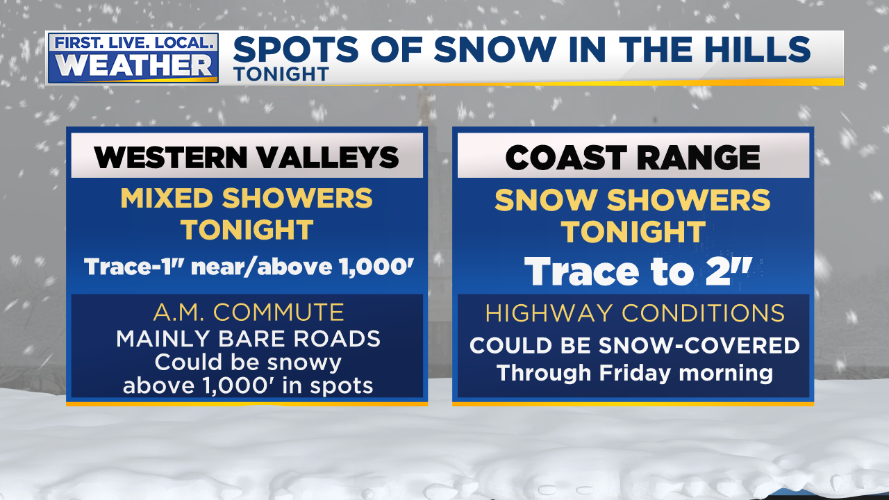
After tomorrow midday, snow levels jump back up to around the passes. This is quite possibly our “last chance” for snow this month.
So did you have the impression we had significant snow on the way this week? Like a snowfall that could paralyze the metro area and give us a hellish commute?
Here’s the forecast timeline:
About 10 days ago we first put “mixed showers” in our 7 Day Forecast for this past Monday. Yes, it’s a tough decision whether to throw a snowflake/rain mix into the forecast. Because viewers and coworkers notice immediately. Models clearly showed a cool/showery weather pattern, but not one that produces widespread snow. So seven days ahead of time we forecast those mixed showers with a high of 40 for this past Monday. For the following 6 days we had a high of 39 to 41 degrees for this past Monday and kept the same forecast. That’s exactly what happened!
How about Tuesday? We first forecast “mixed showers” six days ahead of time. Then we changed it to “flurries and sun” five days ahead of time when it was obvious there wouldn’t be much moisture left that day. Guess what? We had flurries, sun, and a little graupel that day. Highs were always forecast between 35-37. We hit 40 with the sunbreaks. Close enough, so for seven days we had a great forecast for Tuesday as well! No problem so far…
How about Wednesday’s forecast? This is where things got a bit more intense and we as forecasters were thinking could be the “real deal”. Models were generally telling us we might have the perfect setup for large regional snow/ice event with cold east wind pouring out of the Gorge. Or maybe just in the metro area, depending on the model. Six days ahead of time we had “snow developing” and “snow or freezing rain” in the 7 day Forecast for Wednesday/Thursday forecast with highs at/below freezing. That would definitely imply something big might be in the works. For three days we kept that general wording, telling you something like this:
By Saturday, still four days ahead of time, I said this in the blog about Wednesday’s possible “big event”

By Sunday afternoon, the chance of a major event Wednesday was still alive, but on life support. Some models were pushing the big low offshore farther north, ending our brief cold spell quickly. Our most reliable models (ECMWF & GEM) were saying there would be little or no snow…3 DAYS AHEAD OF TIME! I wrote this on the blog Sunday evening:

Then by midday Monday it was very clear Wednesday could easily be a non-event. From my post that day:

TO SUMMARIZE OUR FORECASTING HERE AT FOX12
We nailed the Monday/Tuesday forecasts well ahead of time, calmly letting you know that your “life would continue as normal” through most of this period. Expect to see snow in the air but not much on the ground at the lowest elevations.
We did indeed indicate Wednesday/Thursday could bring life-altering snow/ice to our area, but backed off drastically 2-3 days ahead of time. We know that can be the case as we get closer to an event. Would it have been better to ignore it and then suddenly spring a snowy/ice forecast on you just two days ahead of time? I don’t think so. Keep in mind we can’t just leave those last 2-3 days of the 7 Day Forecast blank! We have to put SOMETHING in there.
WHY THE FEELING THAT A “SNOWMAGEDDON” WAS COMING?
I think it’s a combination of factors:
Today’s connected world: There is a constant flow of information on TV, smartphones, & the Internet. Rumors of snow, ice, cold move around in circles and pass through social media instantly. The volume of information is staggering; we are exposed to far more “snow may be coming” posts/blogs/tweets than even 10 years ago. Every news/media organization is promoting their brand or business. I think it’s perfectly natural for a person to think “wow, something big must be on the way” when they are seeing so much of this info. Alert after alert, notifications promoting a newscast, web page, newspaper app, etc… How could I not think a snowy/hellish commute is headed for Portland?
Government organizations prepare for the worst, as they should. But that worst-case scenario can appear to be THE forecast. Leading up to a snow event, city leaders, PBOT, ODOT, WADOT, & counties often put out media releases, tweets, hold live news conferences, show off their newest plows, compare sand/salt pile size, etc… It’s a constant feed of “WE’RE GETTING READY FOR SNOW”. And of course they should always prepare for the worst. After seeing all this info, it’s easy to think “something big is on the way“. No one is doing anything wrong here, that’s just how it is.
Some people WANT to see a good snowstorm. I think plenty of the recent complaints are from people genuinely disappointed we didn’t get a good 2-5″ snow event. That’s fair, but a forecast of a dusting to 1″ up on the hills doesn’t mean we’re “forecasting snow for Portland” and missed it.
A final one, snow forecast maps from models passed around social media. I actually didn’t see it much this time around. It was an issue last February when one local news organization put out a snow map showing 15″ of snow in Portland. These move around as fast as lightning! Generally I don’t like to post images more than about 3 days ahead of time. Notice I didn’t post any snow forecasts for the big Wednesday event here on my blog? This is why.
What do you think? What did I miss. I’ve got a tough skin and would love to see your comments on my Facebook page: @MarkNelsenWeather

Doom and gloom… really??? This is typical PNW weather. If you don’t like it move! Oregon would thank you!!!
What we’ve needed this winter, is a nice blocking ridge of high pressure parked right over Atlanta, GA, and it’s been absolutely non existent.
That tends to put a “kink” in the upper atmosphere (or can), shifting the pattern to dive a nice cold pattern over the PacNW and shove the jet up and across the mid-west and well up into the NE.
No such pattern on the radar, not even close. Bummer…
The dog days of winter.
One additional contributing factor that Snowmaggedon might be coming is all the hype surrounding the long-term forecasts reflected in the Weather App on peoples’ phones. I think you had previously cautioned against over-interpreting the long range forecasts on these Apps, as they’re computer generated ‘point’ forecasts without any human attention given to how the source weather model has been performing relative to reality. But that doesn’t stop all the hype from the public, and that probably comes your way as a result, Mark. Always enjoy your blog, Mark, it’s educational and informative.
Yesterday was a spectacularly beautiful day! 52 degrees with bright sunshine, felt more like 60 until the wind would blow.
Some things I noticed while out for a walk: flowers are coming, if not already blooming. Daphne Odora has bloomed ahead of the crocuses this year. I could smell their sweet, strong fragrance around the neighborhood. Not too unusual, and only a couple of weeks ahead of normal. Daffodils are spiking up already, 3-4 inches in most flower beds that I saw. That seems early. And I saw one rhododendron blossom that already popped open. That one was definitely strange, way too early, probably just a fluke.
Generally, all this means nothing. But, wandering the neighborhood while soaking in the sunshine for an hour was wonderful, a welcome reprieve from the oppressive dark, cold, wet, gray Winter sadness we’ve endured for the last couple months. By the end of the walk I was regretting my heavy coat!
And now, back to our regularly scheduled darkness and gloom.
Your unseasonable warm weather sometimes makes me long for the opportunity for an early break and sunny walk. Here in Idaho I’ve been basically snowed in for a week with several heavy snow storms and packed snow and ice on the hilly steep private road in my little community, only drove out once last Thursday. It is quite beautiful here with everything still covered in snow unlike the Portland area where it melts and drops off the trees and shrubs. I suppose I will get my time in the sun someday soon.
Your 100+ degree sunshine will return soon enough, and all that snow and ice will be nothing more than a distant memory.
Snow is quickly disappearing now from the landscape with a current temperature of 44F and light rain. I’m just happy to finally have seen a good snow event here in January. We had been almost completely snow-free for this month for the last several years!
Went snow wheeling in the Cascades today and the snow that fell recently has a high moisture content. Was a great time but a lot of downed trees from the heavy snow fall. Was able to get to about 2’ deep before having to turn around near 2500-3000’.
Winter can hit hard here in the PNW into February.
Split flow has returned, and the big melt is on for the Cascades.
I thought I would put my two cents worth in about what I see with the Euro model. It was hinting at it on the 00Z run and it’s still hinting at it on the 12Z. One the 12Z, if you look at the 500mb Height Anomaly at hour 144, you can see a nice Low coming off Alaska into the Gulf of Alaska. It tries to come down into the PNW but is held up. It’s still a long ways off but a lot can change between now and Friday.
Let’s hope that something can come from that nice low 🙂
“Stick in the fooooork, the party’s overrrrrrrrrrrrr!”
I honestly hope so!!!
Ok Farmer Ted… Mr. Realistic…
A bit of a snow forecast bust up here as well, last night: Saw a snow flurry around 5;30-5:45pm, and about 2 inches was expected to start after 8pm, but nothing resulted,except some light rain showers and wind. In a way, that’s good- we don’t want more of a sloppy slushy mess than we already have.
Hibernation mode. Set the alarm for full on arctic outbreak.
Mark: I don’t go anywhere else for the forecast because you do the best you can and you admit it when you get it wrong, but you get it right most the time. I’d say you nailed it this past week. Gold star for you!!
I think it’s a testament to your forecasting ability that I still follow this blog religiously, despite the fact that I moved from Vancouver, WA to Rapid City, SD over a year and a half ago. I remember well my own frustration many winters when events that looked promising 5 or 6 days out failed to materialize…and how, once in a while, they ended up being more than we could ever hope for (December 2008 and January 2017 both come to mind).
Those who love snow will never be truly satisfied living in Portland. That’s not why I left, of course…but I’d be lying if I said, as a lifelong weather enthusiast, that the climate out here didn’t offer plenty of excitement. Not just during the winter (which lasts a LOT longer), but in all seasons.
Keep up the great work, Mark. My fingers are crossed that all the PDX snow lovers get some sort of payoff before this winter is over.
Nicely done Swinged Cat!
If you like snow, there is a pile of powdered sugar just 60 miles east to satisfy your snow taste buds.
True that. We have options here. If we want snow, it’s just an hour away. I like our summer option of skiing in the morning and playing golf in shorts in the afternoon. If it happens to be raining in Portland that afternoon, you simply head an hour the other way and play in Central Oregon. We got it all!
I did trail work in the Willamette NF on Thursday. Very dramatic snow level at 1000, where it was raining and just wet. We worked at 1250′ where the road was borderline safe to drive and it was snowing like mad. When you have such varied microclimates as we do here, any forecast can be right or wrong very easily. It was a nice day to be out in it.
Me looking at the extended forecast/models: 🤮🤮🤮
We simply live in a (Portland) marine climate where true winter events are really hard to come by—definitely some years (e.g like this year) more than others. Our climate is very unique, however, in that we are very close to climatic regions where winter events are not so rare (e.g. the Gorge), or even common (e.g. Cascades). I think for a lot of we long time W Oregonians, our main exasperation lies in the fact we “can” and in “some” years “do” experience deep winter weather. And the winters in which we don’t, become very frustrating to say the least—even while knowing full well that they are not so uncommon. I cover these points every year with my Massachusetts native wife, half driving her crazy! She politely assures me—after living here many, many years—that she does “get it”!
Crappy weather returns to the PNW. yeah
Ice Storm Warning for the Gorge, up to 3 inches ice accumulation. Are we really supposed to get 3 inches of rain by 8am tomorrow morning??
https://inws.ncep.noaa.gov/a/a.php?i=41979929
That’s up to 3″ snow – ice accumulations will vary. “Total snow accumulations of 1
to 3 inches. Ice accumulations will vary depending on location
within the Gorge”
It says 1 to 3 inches of snow. Ice accumulation will vary depending on location. 🙂
Spring day incoming on Sunday.
Bottom line is that the nuances of weather forecasting – especially in this region – is simply not conducive to the type of instant gratification, icon based weather predictions that like 99% of the population relies on. I actually think the problem is becoming more acute as newer, “better” weather apps emerge that provide such things as hourly forecasting. All these do is amplify the illusion that the apps know what’s going to happen.
But I also think it’s unrealistic to think the general population, who doesn’t really care about the science of weather like we all do, is going to endure long blog posts extrapolating model runs and empirical data to present a more accurate, yet highly nuanced, forecast.
I happen to love weather and often alert family, friends and coworkers of the “real” situation, especially when apps go bonkers (i’ll never forget the seven consecutive snow flake days for Portland in the Apple weather app last February that got people thinking we were headed for a historical event). Thats why all the access to models and this tremendous blog, along with its insightful readers and commenters, is so great. It gives true enthusiasts like me a better sense for reality so I can play weatherman with my own community and help them navigate each event.
Every weather geek in these parts knows that the models often promise much more than we actually end up getting. Plus, they can change radically in a short period of time. Mark was, as always, right to be cautious with his forecasts during these past several days.
That said, there’s a neat little nugget in the latest Reader’s Digest:
“The only difference between ‘mostly sunny’ and ‘partly cloudy’ is my weatherman’s outlook on life.”
Slept in, woke up to 32.0 degrees and a 1/4 inch of snow. Pavillion Park area of Oregon City, elevation of about 450 feet.
Had about 1/2” this morning in Clackamas. 33° and melting
Snow here this morning. 30 degrees. Not much but enough to cancel school.
Well, apparently the 150 feet that the hill Vancouver Heights is situated on was enough to get some sticking snow last night. I woke up to white roofs, yard, and cars. The street was slushy as well so it did stick to the road brief before ticking back over to a rain/snow mix.
But the time you get to the bottom of the hill on Mill Plain everything was just wet.
Thanks for everything that you and everyone one at fox12/kptv do to keep us up to date
Woke up to 39 degrees and rain this morning. Absolutely no evidence of snow, and all the frost from last night’s freezing fog is gone.
👏 S L O W 👏 C L A P 👏
Same here except 34.5 and rain.
To lightning Rod Hill, Dave Sale-Sky and Matt zaffi-no. Take notes from the Cliff Mass of our region.
Good post and forecast Mark. I don’t bother with any other local news sources of weather anymore and love coming here for your analysis each winter.
Any disappointment each time these events crumble is not aimed in your direction. Many of us would just like to see less crumbling 😉 Cold rain gets boring!
Maybe someday there will be a new, highly accurate model named the MNEL 🤔
34 degree rain showers ~350ft lower sylvan area. Glad to hear it snowed somewhere for a minute 😂
Happy Friday!
Foster Powell had some very light dustings. Big floppy flakes when I headed to exercise around 4:45. Seems really random where snow ended up. Walk 2 blocks in any direction and what and how much was on the ground seemed to change. At least the kiddos got a late start!
Just dumping snow in Happy Valley 400’. Solid inch so far on everything but the back edge of this band is quickly approaching so looks like that will be it. Guess we can say winter fell on a Friday this year?
It’s nice to see some snow in my are this morning 🤗❄
Had a trace here in the banana belt when I woke up. All gone now.
If you’re getting down with repeated weather disappointments, start following the stock market. Much more fun over there (lately, anyway!).
I agree. Been making a killing to start the year. Heck all last year was a big win.
Hi, snow! You’re late to the party, but thanks for showing up.
Fog + snow falling could be an interesting sight if we get lucky!
All of you snow people missed a true blizzard last Sunday at Timberline. Winds gusting 35 to 45 MPH, knocking people down shunting down 2 of the lower lifts 15 inches of new snow in 8 hours, burying cars in the parking lot, below 0 wind chills, it was dangerous to be out in that weather! I’ve been on the MHSPatrol for 51 years and that is as bad as I can remember. So all the weather you could handle was only one hour away last Sunday, PORTLAND.
Mark you do a superb joy trying to get a handle on mother nature.
Good description Anonymous. I was in Government Camp and the conditions there were very similar.
I think you nailed it with the comment about social media.
Bottom line? Leave the computer and phone for awhile, go outside and take a walk.
I belong to the “I really want 2″-5″ or more of snow” contingent. I’ll keep hoping.
Exactly!
It all stunk up the place.
It wasn’t about the forecast. It’s that the results matched the forecast. And it sucked.
Owe how I wanted to believe the GFS… I figured it wasn’t going to happen but wanted to believe. After watching the models and seeing consistency run after run it gets exciting, heck that’s what being part weather nerd is about. I don’t do weather forecasting for a living but lived here in Oregon my whole life. In weather anything is possible. It was a fun ride and the mountains got a ton of snow. Not let down at all. The cool weather gave me 4 snowfalls with about an inch +- each time. Snow has been on the ground over a day for 2 of the 4 snowfalls. More snow went to southern/ central Oregon foothills. Owe well. Reading the blog lately shows how sad society is anymore. People seem to complain about everything. I was excited going into it but it’s life. There will be another model ride in the future and another snowstorm.
Great job Mark. You being a seasoned PNW meteorologist did a great job.
It appears we have a light N wind that continues to cool us off.
You didn’t miss anything this time last time you missed a major storm was Jan 2017 Mark Nelson and Rod Hill are my go to forecaster Rod gives me hope for Major snow and Mark tapers off my expectations a bit and I end up with optimism somewhere in a nice middle spot haha side note very disappointed in the new American gfs model
A whole lot went wrong, where does one begin?
Mark, you are my go-to meteorologist every time, because you always avoid the hype and are very thoughtful about what you post. You back up your forecast with graphs and charts and good information, and always strive to give us the very best predictions of what’s to come, year ’round. Thank you!