8pm Thursday…
I’ve wanted to write about this issue for a couple years, but figure now that the weather has calmed down would be a good time. That’s with memories of snow still fresh in our minds.
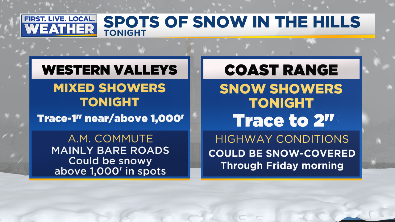
By the way, snow showers tonight will return, with ANYONE west of the Cascades possibly seeing something briefly stick. More likely is a covering of snow on higher hills. Yet it’s just showers so accumulations will be spotty. A hill at 1,000′ in one part of town may be bare but 20 miles away at sea level there could be a dusting. Scattered showers.
After tomorrow midday, snow levels jump back up to around the passes. This is quite possibly our “last chance” for snow this month.
So did you have the impression we had significant snow on the way this week? Like a snowfall that could paralyze the metro area and give us a hellish commute?
Here’s the forecast timeline:
About 10 days ago we first put “mixed showers” in our 7 Day Forecast for this past Monday. Yes, it’s a tough decision whether to throw a snowflake/rain mix into the forecast. Because viewers and coworkers notice immediately. Models clearly showed a cool/showery weather pattern, but not one that produces widespread snow. So seven days ahead of time we forecast those mixed showers with a high of 40 for this past Monday. For the following 6 days we had a high of 39 to 41 degrees for this past Monday and kept the same forecast. That’s exactly what happened!
How about Tuesday? We first forecast “mixed showers” six days ahead of time. Then we changed it to “flurries and sun” five days ahead of time when it was obvious there wouldn’t be much moisture left that day. Guess what? We had flurries, sun, and a little graupel that day. Highs were always forecast between 35-37. We hit 40 with the sunbreaks. Close enough, so for seven days we had a great forecast for Tuesday as well! No problem so far…
How about Wednesday’s forecast? This is where things got a bit more intense and we as forecasters were thinking could be the “real deal”. Models were generally telling us we might have the perfect setup for large regional snow/ice event with cold east wind pouring out of the Gorge. Or maybe just in the metro area, depending on the model. Six days ahead of time we had “snow developing” and “snow or freezing rain” in the 7 day Forecast for Wednesday/Thursday forecast with highs at/below freezing. That would definitely imply something big might be in the works. For three days we kept that general wording, telling you something like this:
By Saturday, still four days ahead of time, I said this in the blog about Wednesday’s possible “big event”

By Sunday afternoon, the chance of a major event Wednesday was still alive, but on life support. Some models were pushing the big low offshore farther north, ending our brief cold spell quickly. Our most reliable models (ECMWF & GEM) were saying there would be little or no snow…3 DAYS AHEAD OF TIME! I wrote this on the blog Sunday evening:

Then by midday Monday it was very clear Wednesday could easily be a non-event. From my post that day:

TO SUMMARIZE OUR FORECASTING HERE AT FOX12
We nailed the Monday/Tuesday forecasts well ahead of time, calmly letting you know that your “life would continue as normal” through most of this period. Expect to see snow in the air but not much on the ground at the lowest elevations.
We did indeed indicate Wednesday/Thursday could bring life-altering snow/ice to our area, but backed off drastically 2-3 days ahead of time. We know that can be the case as we get closer to an event. Would it have been better to ignore it and then suddenly spring a snowy/ice forecast on you just two days ahead of time? I don’t think so. Keep in mind we can’t just leave those last 2-3 days of the 7 Day Forecast blank! We have to put SOMETHING in there.
WHY THE FEELING THAT A “SNOWMAGEDDON” WAS COMING?
I think it’s a combination of factors:
Today’s connected world: There is a constant flow of information on TV, smartphones, & the Internet. Rumors of snow, ice, cold move around in circles and pass through social media instantly. The volume of information is staggering; we are exposed to far more “snow may be coming” posts/blogs/tweets than even 10 years ago. Every news/media organization is promoting their brand or business. I think it’s perfectly natural for a person to think “wow, something big must be on the way” when they are seeing so much of this info. Alert after alert, notifications promoting a newscast, web page, newspaper app, etc… How could I not think a snowy/hellish commute is headed for Portland?
Government organizations prepare for the worst, as they should. But that worst-case scenario can appear to be THE forecast. Leading up to a snow event, city leaders, PBOT, ODOT, WADOT, & counties often put out media releases, tweets, hold live news conferences, show off their newest plows, compare sand/salt pile size, etc… It’s a constant feed of “WE’RE GETTING READY FOR SNOW”. And of course they should always prepare for the worst. After seeing all this info, it’s easy to think “something big is on the way“. No one is doing anything wrong here, that’s just how it is.
Some people WANT to see a good snowstorm. I think plenty of the recent complaints are from people genuinely disappointed we didn’t get a good 2-5″ snow event. That’s fair, but a forecast of a dusting to 1″ up on the hills doesn’t mean we’re “forecasting snow for Portland” and missed it.
A final one, snow forecast maps from models passed around social media. I actually didn’t see it much this time around. It was an issue last February when one local news organization put out a snow map showing 15″ of snow in Portland. These move around as fast as lightning! Generally I don’t like to post images more than about 3 days ahead of time. Notice I didn’t post any snow forecasts for the big Wednesday event here on my blog? This is why.
What do you think? What did I miss. I’ve got a tough skin and would love to see your comments on my Facebook page: @MarkNelsenWeather

Looks like we’re back to the usual boring January weather here(overcast with showers or rain periods). One consolation: we have only 10 days left in the month, and then we possibly go into another exciting February. (I hope)
There is a report of a tornado in the Manzanita area. Wild day.
Didn’t they get hit by one a couple years back?
That’s rough.
Yes, about 3 and a half years ago. Channel 12 was reporting it at noon. It will be interesting to see what they have at the 5pm news.
Like it of not we are still in the low elevation theoretical winter weather window and will remain so until mid February (by some standards)—or even the first week of March (by others.) So all we can do is grin and bear it. Hardly the first time. Nor the last!