8:45pm Wednesday…
Today turned out pretty much as expected, with a few last minute twists & turns.
- We saw a rain/snow mix which changed to mainly rain as the cold front moved through during the evening commute
- Clark county warmed up to around 40 as our “mesoscale” models showed; no snow for most of you up there.
- No measurable snow for almost all of us.
What was different than expected?
- Cold Gorge wind was very persistent (surprise!). Although quite a bit more reasonable compared to a few hours ago, it is still transporting cold continental air westward into the eastern edges of the metro area. Temperatures are hovering just above freezing in a narrow area along the Columbia River east of I-205
- Due to that, plus the cooling air overhead, snow has been falling for several hours in the western Gorge, all the way into Camas and Washougal. Just got a report that two inches have fallen in Bridal Veil, that’s where we should have only seen freezing rain.
Take a look at current temps, only the numbers below 34 degrees plotted below. (click for a better view)

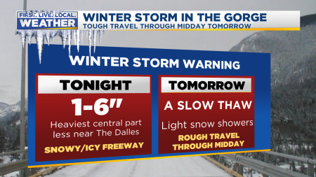
Areas to the right of the yellow line are generally seeing snow. Mainly or all rain to the left. Yet in general the snow level west of the Cascades is around 1,500 to 2,000′ right now. Then how is it snowing down to the Columbia River in Clark and Multnomah counties? What would typically be about a 1,500′ snow level right near the Gorge and into Camas/Washougal has become “sea level snow” since the last 1,000′ or so are near/below freezing due to that east wind; snowflakes are coming down much lower than one would expect in this pattern. Due to this, and more precipitation on the way, the NWS has upgraded the western & central Columbia River Gorge to a Winter Storm Warning. 3-6″ likely in these areas. The pressure difference through the Gorge does continue to weaken and it’s possible at some point Camas/Washougal/Troutdale lose the easterly wind. If so temps will rise a few degrees. They sure won’t go down any lower through tomorrow morning.
Through the rest of tonight we’ll see waves of showers moving onshore behind this evening’s cold front. In general the snow level will remain above 1,000′ through tomorrow morning. But anyone at/above that elevation in the metro area could see a skiff of snow on the lawn/barkdust/car. Same setup again tomorrow night and Friday morning. Beyond that time we’re headed back to a milder weather pattern for the last 1/3 of January.
Chief Meteorologist Mark Nelsen


 Posted by Mark Nelsen


