 A busy weather evening with a cold front moving inland…nice little line of heavy rain coming over the Coast Range right now. Then after checking temperatures/dewpoints in the Gorge, I decided that it looks good for .20-.40" of precip falling in frozen form tonight. That should be mainly above river level (I-84). The flow turns westerly tomorrow, so temps rise up into the lower 40’s.
Here in the metro area, just showers and sunbreaks for Saturday with lots of post-frontal cold airmass showers showing up on the infrared satellite looper.
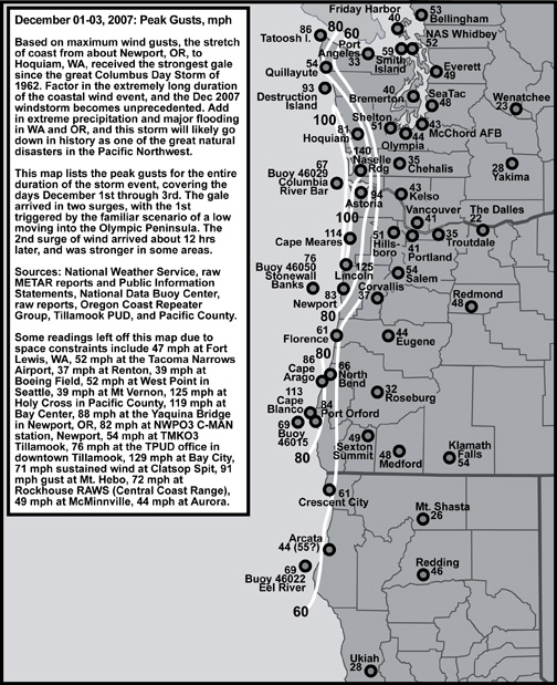
System #2 arrives Sunday morning…I still see low level wind along the coastline forecast at 40-45 kts. That should produce gusts above 60 mph for the first wind "event" since the "Great Coastal Gale of 2007" (unofficially named by Wolf Read, thanks for the graphic). That cold front is going to be a juicy one with quite a bit of snow in the Cascades too.
As for Tuesday, I notice there has been some vibrant discussion in the previous post’s comments (and now I assume in this post). Models HAD been showing a surface low moving onto the coastline to the south of us, then tracking in towards N. Idaho. Now the 00z GFS shows a weakening low moving towards the coastline kind of "morphing" into a low up near Puget Sound by Tuesday evening. Hmmm, I assume future model runs will look much different. Regardless of the track, it wouldn’t be cold enough to snow in the lowlands of Western Oregon since there is no significant cold or dry air in place over us at the time. More important, the low level cold air currently in place to our east will be wiped out by systems number 1 & 2. Possible yes, but very unlikely for us to get snow on Tuesday then.
Beyond that…more systems later next week…anything is possible, so lots to watch! Got to go now…11pm show awaits…Mark Nelsen


 Posted by kptv