4pm Thursday…
Your Valentine for today…
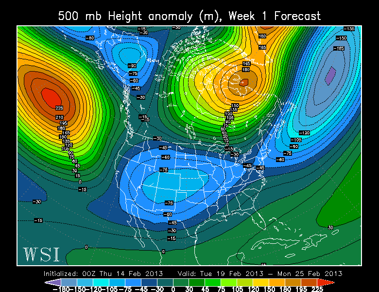
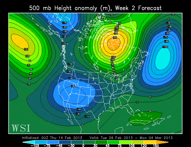
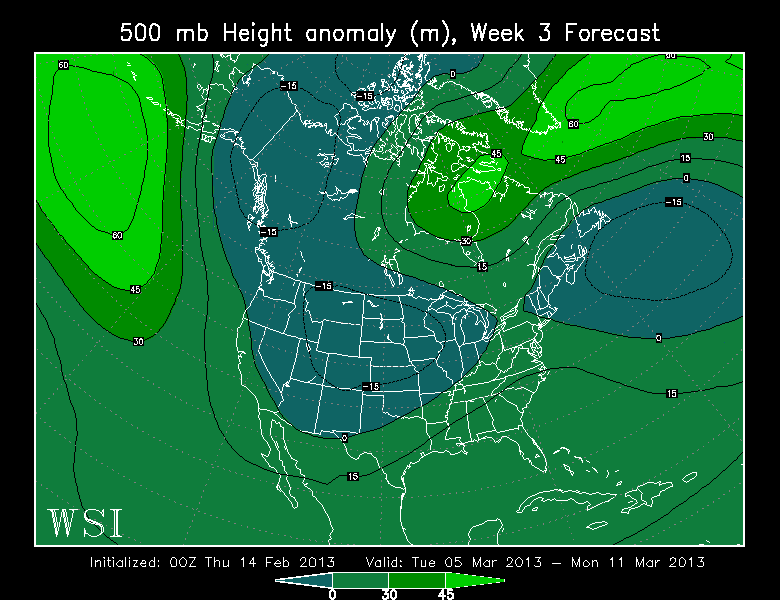
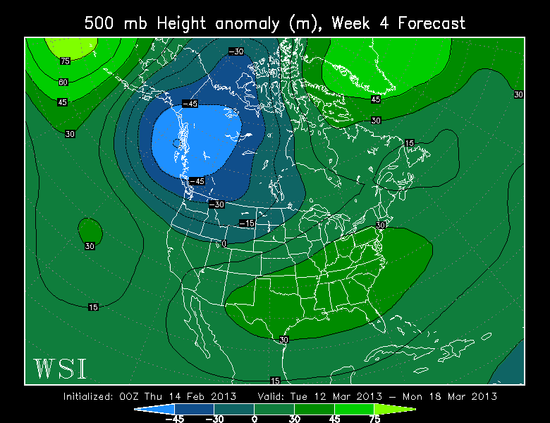
You know the deal, the weekly average 500mb heights from last night’s monthly run of the ECMWF. Looks wetter and cool as we head into the middle of March? Hmmm…surprise…
4pm Thursday…
Your Valentine for today…
You know the deal, the weekly average 500mb heights from last night’s monthly run of the ECMWF. Looks wetter and cool as we head into the middle of March? Hmmm…surprise…
This entry was posted on Thursday, February 14th, 2013 at 3:52 pm and is filed under Weather. You can follow any responses to this entry through the RSS 2.0 feed. Both comments and pings are currently closed.
THE BASICS:
Commenting on this blog is open to anyone with an interest in or fascination with weather. Here at FOX-12 we're happy to provide you a space to "geek out" with fellow Pacific Northwesterners. But please don't abuse the privilege.
1. POSTING LINKS/VIDEO:
It's okay to insert video or pictures, as long as the link points to something appropriate for the general public. No politics, obscenity, etc...
2. CHOOSE A NAME ONCE:
Choose a name or identification once and stick with it. The very first time you comment it is held for moderation. After it's approved, that EXACT name will be allowed to comment at any time. Note that this applies to your IP address too. So using the same name but on Grandma's computer will require a one-time hold as well. This keeps the spam out.
3. NO PROFANITY:
This is pretty obvious, but avoid being rude or taunting others too.
4. NO RACISM, OR VIOLENT THREATS:
This will get you kicked off quickly. Please report this to me at mark.nelsen@kptv.com if it happens here.
| WEATHERDAN on An unremarkable May this year,… | |
| Snomanski on An unremarkable May this year,… | |
| Roland Derksen on An unremarkable May this year,… | |
| Roland Derksen on An unremarkable May this year,… | |
| Jim on An unremarkable May this year,… |

Hmmm, Kinda of a exciting weather day today. Pea size hail, heavy rain not a bad day. Looks like Boston is going to get a foot of snow again !!
62 here today in BG. It’s the first 60 degree day in February (for me at least) in 5 years!
It’s amazing what SOUND can do…it has force! This from the Russian meteor today:
http://www.wired.com/autopia/2013/02/russian-dash-cams/
Do you know why there are so many great videos of the meteor in Russia? This article explains why nearly every Russian has a dashcam. Video 1 and 3 in the article have GREAT meteor videos. Video 2 is a car accident. It’s unreal. view full screen
Advised when driving through Milwaukie
flurball you are SOOOOOO right!!!
Anything worthy of mentioning on the GFS or EURO?
Cool but not cold!!!! Cold rain at times
Bleh, what about the end of the month?
I think there is a possibility of maybe some light wet snow showers Sunday night/Early Sunday morning per the 18z GFS. We’ll see though. No reason to get excited.
Really Josh? Sounds good to me, but did you mean early Monday morning?
He must cause Sunday just ain’t happenin, sorry……..
LOL, yeah I meant Monday. It’s still possible we won’t really know until the time comes and passes. But 00z says no. I expect that to change about times before it comes.
6* times
Just hit 60 in La Center wow what I nice day last one for a while go out and enjoy:))
Oh yeah, take THAT rain/cold weather lovers, what a day!!! Thank you sir Mark, may I have another?!?
No
Ouch, that hurt. But at least the 7 day says warm & dry tomorrow (but yet there is a rain symbol in there) Way to hedge that forecast Mr.Nelsen!!
50 now – I (humbly) predict 61
Humbleness duly noted…pride goeth before the fall.
It missed!! \^_^/
But its little brother scored a direct hit!
Already 43 degrees, forecast high is 54. This now marks 19 consecutive days of nice walking weather outside.
For anyone interested, live info about today’s 2012 DA14 asteroid flyby on NASA TV, full coverage begins at 11am PST, so in about an hour.
http://www.nasa.gov/multimedia/nasatv/ustream.html
On the air now, link to more stable streaming video:
http://www.nasa.gov/multimedia/nasatv/index.html
I like how one guy describes the asteroid as 150 feet, “half the size of a football field”, and the next one says 150 meters, “the size of an office building”. I thought NASA’d already learned that lesson??
I wanna know how many times the size of a football helmet that works out to…
Are these events connected?
The meteorite in Russia and the asteroid approaching this afternoon are “completely unrelated,” according to NASA. The trajectory of the meteorite differs substantially from asteroid 2012 DA14.
“Information is still being collected about the Russian meteorite, and analysis is preliminary at this point,” according to the NASA website. “In videos of the meteor, it is seen to pass from left to right in front of the rising sun, which means it was traveling from north to south. Asteroid DA14’s trajectory is in the opposite direction, from south to north.”
Sorry, Erik – you can take off your tinfoil hat, now.
Well, I guess that answers that question then…
Thanks for doing all the leg work!
Tinfoil hat, huh? 😆 You’re so funny!!
Thanks…
That thing’sbookin’!
…so fast I couldn’t hit the space bar!
“another…potentially colder low will bring a chance for more
precipitation Thursday.”
National Weather Service Portland or
839 am PST Friday Feb 15 2013
Long term…Monday night through Thursday…the upper trough will form a cut off low off of southern Oregon by Monday night. The low will push inland Tuesday with wrap around showers bringing periods of rain and mountain/foothill snow Tuesday. Another period of brief ridging is modeled to build in for Wednesday…keeping things mainly dry. But another…potentially colder low will bring a chance for more precipitation Thursday.
In other news…
Medium foggy and 39.7 here – a slight stirring of Easterly breezes.
I’ll be watching for the disc of the sun (at least) over the ridge shortly – I already see the localized brightening – indicating the likely persistence of this soup.
Hoping for full beam by 10AM.
Full on sunshine this morning in Happy Valley after a brief stint of fog earlier. Time to get out and turn the garden over.
Still too wet here…
…maybe spray some Roundup.
Breakout at 9:50 – Hooray!
Here’s another NASA kink:
http://www.nasa.gov/mission_pages/asteroids/news/asteroid20130201315144.html
Some links for the asteroid, “2012 DA14” flyby:
http://science.nasa.gov/science-news/science-at-nasa/2013/13feb_asteroidcoverage/
Completely clear here and 31 degrees this morning. It promises to be a beautiful day!
2/14/2013 Oregon (All) Temperature Summary
Warmest:
High:72 at BROOKINGS( 79 ft)
Low: 49 at BROOKINGS(79 ft)
Coldest:
High:27 at HOWARD Mt Howard(8150 ft) & CW7477 Lostine(7002 ft)
Low: 11 at ANEROID LAKE #2 (7300 ft ) & CRAZYMAN FLAT (6100 ft )
Largest Diurnal Change: 38 degrees
Horse Ridge (US (54/16 ) (4160 ft )
Heaviest Rainfall:
0.08″ at CW6318 Welches(1283ft)
0.07″ at Astoria Regional(10ft)
Russians get all of the cool meteors…wow…amazing stuff…at first I thought it was another viral video prank…obviously not…
Amazing photos and videos all over twitter. Reports of 200 people injured on BBC. Unreal…
http://www.slate.com/blogs/bad_astronomy/2013/02/15/breaking_huge_meteor_explodes_over_russia.html
Just minutes ago over Russia!!
https://twitter.com/a_koretsky/status/302272831029391360
Hey W7 whats going on ?
Looks like a chunk of rock from space came careening into the atmosphere over Russia. The shockwave has apparently caused some damage, and reports of possible casualties. Something may have reached the ground, too. Not sure yet. Details are still coming in.
This may or may not be related to the asteroid set to pass midday tomorrow (for us). I’m wondering if this wasn’t possibly a smaller, unseen chunk that was travelling just ahead of the main asteroid? If so, how many more are there, and might we expect something like this once we rotate around toward its path in the morning??
Lots of questions…
Well at least we know they have great car alarms there !
And they love taking videos with loud Russian music in the background!
thats crazy
Closest approach of the main asteroid will be at 19:25 GMT (11:25am PST) tomorrow. It will be passing by at ~17,000 miles above the Indian Ocean, so I think we’ll be fine on this side of the planet. I wouldn’t mind being woken up by a sonic boom, however!
Where was NASA on this one? They were sure proud of the one they saw that wasn’t going to hit the Earth. How crazy, I saw a blueish streak in the sky on the way home tonight when I was on I 205 around 9:45. Wonder what else is heading our way, better where a hard hat to bed tonight.
The one “they” saw coming — which still has yet to pass by — is about the size of a football stadium. The one that exploded over Russia earlier today was maybe the size of a compact car.
Latest info has injury count up to about 1,000 people, mostly from falling glass.
http://www.kptv.com/story/21203652/meteorite-falls-in-russian-urals
Chelyabinsk (Челябинск) is a city of about 1 million people, roughly the size of Portland, I suppose. Imagine a small nuke detonating 30,000 feet overhead.
“The Earth travels about a million miles in a day and these are two events separated by almost 24 hours, so it is unlikely they are connected,” says asteroid expert Richard Binzel of MIT. Meteors the size of the Russian one hit Earth every few years, Binzel says, but land near inhabited places much less often. “We just have the incredible coincidence of this happening just before the asteroid flies by,” Binzel says.
Incredible coincidence, indeed! Although, I don’t necessarily believe in coincidence. It is true that the Earth travels about a million miles a day, however, cut that distance in half since this occurred only about 12 hours ahead of the passing of Asteroid 2012 DA14. I don’t know if the trajectory is similar or not (I haven’t looked into that yet), but it’s not totally inconceivable to believe that a random space rock set to graze our planet could have smaller debris nearby — ahead, behind or alongside. On the grand scale of things, 500,000 miles isn’t really all that far.
Maybe it was the arrival of the new Pope? Was it headed toward The Vatican??
With all due respect, I’ll go with the guy from MIT.
I am loving all the negative numbers on the weekly maps Mark. I knew winter was not over yet. The fork kept falling out of winter 😉
I love them too…but is there any value to them at this point in our loser winter??
Have faith Alan I think something might be coming for one more chance yet. 😉
Ok, I’ll keep the faith. I just want sticking snow before the cold spring starts. Hope you’re right Greg!
Of course it’s going to be a cold spring…
Cold NE Pacific…. Trend of the last few springs… CFSv2 suggesting cold March… CPC outlook for cold spring…. Smart money is on a cold nasty spring
Can’t argue. The tradional spring or fall temps to the calendar are not what they used to be.
The PDO actually isn’t all that cold right now, just slightly below average…so perhaps the CPC maps are pulling a boner on us…
Tee hee, you said boner!
Ummmmmmmm………..
^_^
XD
Just a cycle, it’ll eventually warm up…one of these springs. Last year wasn’t too bad in April and May, June was the really bad part.
March was the bad one last year… As was June. April was pretty good (except for the first part, which was an extension of March) and May was okay (the last part of the month wasn’t really different from June.)
Tomorrow could be a great taste of spring you won’t see for a month unless you can get east and or at some elevation. Otherwise it seems we are in a rut of cold springs and late summers. I understand true north magnetic poles change and it seems our traditional calendar for warmth/dry and cold/wet is also sliding forward based on the last several years. Spring forward and fall back have seemed to advanced in my lifetime as far as weather is concerned.
It’ll change again – it’s just a matter of when.
And when it does flip back, it’ll probably do so with a VENGEANCE! Think record warmth in March and April….
Hopes for snow
ten to fifteen days out
smacked down, dead
俳句謝罪
haiku apology
ワックスオフでワックス (Mark’s note: This better not be Japanese swear words Larry!)
error in structure
five seven five is correct
count those syllables
It says “Wax On, Wax Off” Mark. You can copy/paste it into Google Translate.
Haaaa, Larry!
Yeah, should have used my abacus.
I keep asking myself how many more years are we going to have wet and cold March’s and warm dry September’s. I truly miss the days where we get our first 70 day in March and then have a nice June. This pattern can’t last forever. A sunny 80+ degree day in June is much better than an 80+ degree day in September due to the long day length.
Hey, good thoughts.
Two more years
I heard that down in San Francisco they were expecting their first 70 degree day soon. I will have to check that at the NWS site down there. Paul Deanno at KPIX down there actually made it a highlight on his forecast. Looks like right now would be a great time to visit Brookings, Oregon as well.
It wasn’t that impressive in Portland after February, but the whole Feb-May period in 1968 was dope in The Dalles. WAY above climo for Feb, Mar and May – and slightly above climo for Apr.
NWS backed off on the minor snow possibility. That clearly means snow.
Yes, yes, but no. Nice try, but it doesn’t look like snow on that day that they used to say that minor snow possibility. But it is true that when they say it’ll rain it’ll snow! Ya never know!
I’ll take credit for the reminder to post these!
Does anyone know a snow dance?
This Spring wiil be a normal one. Some sunny warm days, and some cool wet ones. I look upon the computer models as entertainment, nothing more. How many major storms or cold blasts were on the computer models this winter.? And how many actually happened here this winter. Nada, Zip, Zilch. Let the tv mets forecast weather up to a week out, ok. But saying that spring will be a bust because a computer model says so is foolish. You might as well read tea leaves or look into a crysal ball. Once you get out much past about 7 days out on the GFS, and about 10 days out on the ECMWF the accuracy seems to drop off rapidly. This current winter weather pattern we are in is not at all like the last three winters. And I have every confidence that this Spring will be nicer than the last three. That said our normal Springs have a lot of cruddy weather and I’m sure we will get our share. I am looking forward to having some nicer days in March.
Calling Spring a bust this early is stupid…
But I don’t think Spring is going to be that good this year. Just a gut feeling that, at least March, will end up cold and wet… Just blah weather. I keep thinking (and I sincerely hope I’m massively wrong) that we’re going to end up with a worse March this year than last year’s terrible performance. And I don’t think April is going to be much better. Though I have a feeling May is going to end up nice.
In my case (and I suspect in the cases of others around here), there’s not much in the way of science, rhyme or reason… It’s just a gut feeling. Unfortunately those gut feelings are just as accurate this far out as anything else. 😛
I ‘try’ never to look more than 3 days ahead, usually = disappointment for me no matter what the season……..usually.
Just like calling this winter a bust in November was stupid? Riiiiiiiiiiight… Well, I guess we can all rehash this again come June, ‘kay?
Sheesh…
Last day of winter is March 22nd and so is the first day of Spring. Don’t count your chickens until their all hatched but at the same time don’t go to far out on the forecast limb to predict an epic late season snowstorm. We’re due for a warm Spring and early summer surely but the trend for both on the CPC NOAA charts is not looking all that impressive for it.
Come on Gregg, you know the “official” definition of winter is way off in terms of average temps, at least for the Pacific Northwest. November 21-February 20 is the coldest quarter of the year, not December 21-March 20.
Actually I like to think of the whole period from Halloween through Spring Equinox as the “greater winter season” with the two “big” months usually being December and January. November is the transition INTO winter, while February and early/mid March are the transition OUT.
I said this would happen …grrrr..
This has all happened before, and will all happen again.
Haha! So say we all
I’m liking the trend!!! http://www.wetterzentrale.de/pics/MT8_Portland_Oregon_USA_ens.png
Yes, that looks good but this late in winter it’ll pan out to be cold wet rain, and then to an average spring (whatever that is)
Like last Sunday, about an 1 hours worth of sunshine. Hopefully @ least 2 tomorrow yes………….
You just had to whip out that Inferior ECMWF.. didn’t ya. ^_^
Greg? Do you have a comment about that?
Ahhh you betchya Mark.
I like that the NWS has been watching a retrograding pattern now as they have mentioned in their discussions. I actually saw some of that going on some 240 hrs ago from this current post here. It was not a stable pattern as there appeared at times to be some westerly flow in the 500 millibars level at times but it seemed a ridge wanted to stay offshore at any rate to the southwest of us. Looks like the GFS sort of jumped on board and the NWS is pessimistic right now about it because the colder stuff is a ways off but I am still seeing a pattern trend that brings the colder goods to us. The only bad problem about a sharp ridge though offshore is it tends to take everything to California where The Sierra gets all the fun and excitement and we get nothing but cold and dry air around here.
It will surely be more exciting than what I have had though so far here in Southeast Tacoma. Only two days of freezing or below. For that matter I have only had drips and drabs of precip as well with a whopping total of just 0.26 inches. Ugh…Another below normal precip February is in the making but then again based on the ECMWF I did say that I think we will be more wet in the second half of the month. Hmm the trend is not playing out real high on that idea at the moment but we will see how things look after Saturday when the NWS says a front should usher in a colder air mass here.
Notice Mark…I mentioned “Looks like the GFS sort of jumped on board”. I did not put it in front of ECMWF because in my belief it is a far more accurate model than the GFS.
Okay now off to look at the Canadian GEM. My second model of choice also ahead of the GFS. 😉
The Canadian GEM Global showing a pretty good diving pattern toward the south far from Oregon and Washington. California should get all the fun for this time period.
Grrr, the maps are all liney for me!! 😦
You in
Well, of course, Erik – there ARE lines on the maps.
That’s kinda the point, I think.
..I’m pretty sure Eric talking abut the same thing i’m seeing, which are the grey overtones with lots of lines on (for me) the 3 bottom charts…
…darn cheap keyboard of mine…:(
Yeah, they look like this to me…
Tell me honestly that’s normal? Otherwise, methinks it’s a legitimate issue.
When you actually pull up the map (click on it) are the lines still there?
They look good when I click on them. Maybe Erik has had 1 to many bottles of wine tonight.?
The thumbnail for the 3rd one down is “liney” for me but the full screen pics (when clicked on) work fine for me (on Chrome).
They look fine when I click on them, Mark.
No wine tonight, Josh. Completely sober. I typically don’t drink alone, on principle. Poor form. It’s a social thing for me, and tonight I have no friends. Throes of single life, I suppose? But, tomorrow’s Friday!!
…and now the grey is gone…