7pm Sunday…
I can’t find any rain for the FOX12 viewing area in the next week. And almost EVERY DAY will be sunny. But hang on, there’s a big catch; Monday night & Tuesday will be very windy and chilly for the entire metro area. In some parts of the Pacific Northwest this will be a historic cold snap for so early in the cold season.
First, today was a fantastic late October day; brief spots of fog and then all sunshine. High temps right around 60 are normal for this date. Although the low of 33 was much cooler than average

October continues to be the coldest in Portland since 1969.

I was 6 months old last time we saw an October this chilly in Portland…let that sink in. And now it appears the last three days of the month (not tomorrow) will be unusually cold for late October, especially east of the Cascades. In fact the airmass coming out of Canada will be the coldest we’ve seen around Halloween since 2003!
THE HIGHLIGHTS
- Expect mainly sunny skies through at least next Sunday.
- Monday will be nice again, just like today. Comfortable temps and light wind
- Around midnight or so tomorrow night, a strong east wind develops over the Cascades and comes down into the foothills. Strong and/or damaging wind is POSSIBLE in a few isolated spots. Where gusts exceed 40 mph is a tough call. Could be eastern Clark county, eastern Clackamas or Marion/Linn counties. I mention 40 mph gusts because in these areas a strong east wind doesn’t happen very often.
- After midnight (early Tuesday) that wind will descend into parts of the metro area too. At sunset tomorrow it’ll be calm in Portland, but for many areas the wind will just suddenly pick up at some point during the night. Probably a few limbs will fall onto power lines and give us a few outages. Gusts 35-50 mph are possible. Everyone gets SOME easterly wind, but only a few spots get gusts over 40.
- Tuesday will be sunny, windy, & chilly across the region. Portland metro temps only top out around 50 degrees; not record cold, but close.
- Cold air across eastern Oregon will be some of the earliest you’ve ever seen along with a gusty north wind. Very cold in Cascades too; Timberline goes from around 40 tomorrow to 15-20 (high temp) Tuesday! Expect easterly gusts 40-50 mph up there too. Hiking in Cascades Tuesday will be just like wintertime; without snow on the ground of course.
- Wednesday the east wind returns to the usual spots in the western Gorge and east metro. All other areas will calm down wind-wise.
- Calming conditions Wednesday-Friday mean the coldest outlying areas west of the Cascades could reach 18-25 degrees for lows. We haven’t seen this in late October since 2003.
Where is this coming from? Northern Canada, way up in Northwest Territories.
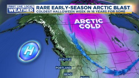
By Tuesday morning, that lobe of a cold upper-level low over Canada will be right over Idaho

How cold? 850 millibar temps on Tuesday morning are forecast down to around -12 over Spokane. So around 4,000′ elevation it should be about 10-12 degrees F! That same airmass pushes up against east slopes of the Cascades. That means Timberline Lodge and Mt. Hood Meadows, plus the upper parts of Skibowl will be somewhere between 10-15 degrees Tuesday morning and struggle to get above 20 by afternoon! That’s midwinter cold. Speaking of records, Spokane has not seen anything colder than -12 (at 850mb) before November 10th, so this is the earliest it gets there. At Boise, the sounding each day has never been lower than -8 (at 850mb) before November 12th. Models are forecasting around -11 Tuesday morning there, a full two weeks earlier then the previous record! So this is historic cold over the inland Northwest and Rockies.
Notice we are right on the edge of the cold air, so the main effect will be strong east wind for one day (Tuesday) all areas and then a continuing east wind Wednesday closer to the Gorge as upper-level temps warm dramatically through Thursday. Dewpoints will be dropping below 10 degrees west of the Cascades. Think dry desert air that cools quickly at night. Calm areas that get up around 50 during the day will drop into the low-mid 20s Wednesday morning. I think the coldest spots west of the Cascades will be in the 16-20 range at some point Wednesday-Friday mornings.
Last time this happened was in 2003; yes, I actually saved this map from 16 years ago. Weird, I know.

The trough was a little farther west and stayed over us longer compared to what is forecast this week. PDX saw five days with highs below 50 degrees starting on Halloween that year. We ended up with a low of 26 from that cold spell.
Then one year previous (late October 2002) a similar setup brought record cold to our region. I have it in my notes that it was the “coldest airmass of the season”. That was a very mild winter, but I’m not sure if I was referring to the general setup or if it really was the coldest airmass to come south. Regardless, look at those low temps on this slide I presented at a winter weather recap the following year:

That 2002 event was more like this one; cold air comes in quickly and leaves quickly in a couple days. Notice it set October lows for several stations. In Portland we’ll have to drop to 25 to set a new October low. There’s no reason that couldn’t happen if wind goes calm at PDX at some point Wednesday night. We’ll see.
Enjoy the sunshine Monday, but be ready for a big chill and lots of flying leaves Tuesday!
Chief Meteorologist Mark Nelsen

First light breeze blew in the window at 12:30am, heard gusts picking up through the trees outside by 1:30am. Nothing over 15 mph, however, and it was relatively calm at 6 when I was heading out.
MAX trains were AFU, TriMet claiming due to power outages. The winds in downtown were incredibly strong and cold. A veritable blizzard of leaves on my walk down to my office! Would estimate gusts over 30 at street level, but the way it circulates between the buildings, there’s no real direction to it, it’s all chaos.
Let me try this again (forgot to login) 1/2 inch of snow last evening and the clear and cold. 14 degrees this morning in Kamiah, ID
1/2 inch of snow last evening and then clear cold skies, right now it’s a chilly 14 degrees in Kamiah!
Is this still “on”? It’s 4am Tuesday morning, and I’m seeing 1MPH wind in central Gresham.
Winter coat in the morning – woot!
By morning, I’ll bet you’ll be able to count the number of leaves remaining on trees in the Portland area on one hand. Ok, maybe two hands.
My neighborhood has lots of leaf piles and they’re bone dry. This is gonna be interesting!!
25 for a low this morning. Hoping for teens this week. Still October, SAY WHAAAAT!?
I just moved over to Kamiah Idaho this past spring hoping to experience true 4 season weather! Looks like I’m getting what I wished for.
Bring it on!! It’s already down to 32 in Hillsboro.
After this almost historic october cold, we’ll have a mild and uneventful winter like 2002. just saying.
Most likely, cold early then warm i guess 1949/50 winter is out the question ever again thaks global warming.
I’m thinking maybe winter will be like ’04. Halloween ’03 was cold like what’s forecast tomorrow, then in January (I think) we had a big snow/ice storm.
Is that what your crystal ball is telling you?
I’ll second Lurkyloo’s thoughts,
hoping for a January 2004 redux!
Thirding it. Especially after what winter weather weather confrence said.
Or like winter 1991-92? 🙂
Thanks for the update, Mark!
It was good to see you yesterday.
Well if this artic blast ends up being the coldest air of the fall/winter season then we better enjoy it now just in case.
So would this count as a widespread arctic blast that we’ve been missing since 2014 or does it have to be colder?
Bring on winter.
Ehhh, no.
It would have to be modified Arctic air coming down into the Willamette Valley straight out of the N or NW. This is more our typical “back door” scenario, cold air setting up Eastside and rushing into Portland Metro down the Gorge and spilling over the Cascades crest.
It’s going to be cold here. It’s 34* as of 9:30pm. Did I understand there was a Weather Conference at OMSI on Saturday? Neutral weather pattern? (No la nina or el nino). Please fill us in!!! Always watching your weather Blog Mark!!!
Yes there was a conference on Saturday. Neutral ENSO and PDO index. All the presentations should be posted in a couple of days on the Oregon AMS website.
Over here in south central Idaho I have a feeling we’re going to be crushing the record lows. The record low for tonight is 22* and our low is supposed to be 14*. On Wednesday morning the low is supposed to be 5*. I’m curious what the lows were during the 2002 & 2003 arctic outbreaks. It has certainly been an October to remember this year!!!
Yea no way those old records will hold for you guys out there. You all had snow in the Rockies well a month ago already. Brrrr! Is all I have to say to all this and now we’re supposed to get windy event out of this here too?
I was marveling how quick Summer came and went. Now Fall wants to leave too – is Spring on the way lol? Narly weather.
Hope it’s a sign for the dead of Winter being something awesome for us all in the PNW.
Thanks for that update, Mark. I am enjoying these crisp clear days.
Should we be protecting outdoor pipes and faucets this week if we’re 82nd Ave distance East??