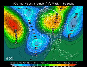
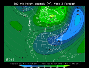
We already have the general idea (from the previous post today) that cooler than average temps are on tap for the next 7-9 days. Then the first wet westerly flow we’ve seen in quite a while.
What about beyond that time? That would be maps #2-4 below. This is the monthly run of the ECMWF split into the next 4 weeks. Could we actually have a mild start to March??? Maybe…maybe.
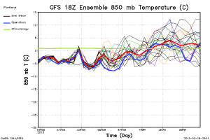
I’ve included the 18z GFS ensemble chart which says after next Monday-Tuesday we’re headed to milder weather. It also shows the operational model is the coldest in the Sunday-Tuesday period too.
I need to get those forks sharpened…


Getting a decent hailstorm right now. about 1/4″-3/8″ hailstones.
Awesome day. I just got my camping gear ready and washed out. I was just sure thunder storms would come out of all this sunshine, but the northerly flow must have cut off the development. A few dark clouds out there now, nothing too interesting according to radar.
http://www.wunderground.com/radar/radblast.asp?zoommode=pan&prevzoom=zoom&num=6&frame=0&delay=15&scale=1.000&noclutter=0&ID=RTX&type=N0R&showstorms=0&lat=0&lon=0&label=you&map.x=400&map.y=240&scale=1.000¢erx=400¢ery=240&showlabels=1&rainsnow=0&lightning=0&lerror=20&num_stns_min=2&num_stns_max=9999&avg_off=9999&smooth=0
Looks like I won’t be seeing any thunderstorms as of now.
Insanley dark clouds to my NE, insanley blue sky to my SW…
Haha This is some Bi-polar weather 😀
Light rain shower in Camas a few minutes ago. Thunder heard in the distance.
TORNADO WARNING – Redding, CA
http://m.krcrtv.com/w/news/story/85381183/
Tornado warnings just south of Redding, California. Very rare! They might have expired by now.
Oops, you snuck one in under me… 😆
Don’t you guys have something to do? Work or something? 😉
Sunny and almost solid blue sky to the SW of Downtown, to the NE the sky is almost black and looks really pissed off!!
nice anvil building off to my NE. quite large and impressive
Some baby anvils to my NE, quite pretty. One may not be all that small at this point either.
Looks like the atmosphere is destabilizing, someone may get a nice hail shower before the sun sets.
Couple of ’em showing a slight chance of severe hail. And they appear to be moving our way (PDX metro, that is).
I call that Styrofoam Shower in these parts.. LOL
Ha! And, if these showers survive crossing the Columbia, looks like they will only affect the east metro. Kind of slipping to the SE.
Good view from here in Hillsboro. Fingers crossed for some thunder….
http://t.co/pXhj2Bfw
Pretty gnarly looking contrast coming off Silver Star Mt. into the beautiful valley sunshine,
Thanks Kent, those are quite lovely! 🙂
Well, it’s a shame those don’t expand out anymore. 😦 Either Mark found a way to block that feature, or WordPress caught on. Oh well.
Oh weird, and now it does expand out?
Whatever, I give up!!
Got some snow today.
https://www.facebook.com/media/set/?set=a.567319383287725.133894.100000290041786&type=3
That small low is rapidly diving south well off the coast this morning. Wonder if we might actually get a nice day out of this development with minimal shower activity. Would still like to see some hail showers if that remains possible.
Ton-o-sun out there presently! (in the Land of gravelly plains)

NWS still think it’s possible (hail shower):
National Weather Service Portland or
911 am PST Tuesday Feb 19 2013
This will leave US in between systems…but with cooler air remaining aloft and breaks in the clouds expected…we expect the daytime heating to cause showers to redevelop. Those that do form could contain small hail…and instability parameters suggest a clap or two of thunder is not out of the question.
Hahaah!
Betcha that got a laugh! Was attempting to post this with the ton-o-sun statement!
http://sat.wrh.noaa.gov/satellite/alternative.php?wfo=pqr&area=west&type=vis&size=1
Every year, there are always a small handful of hold-outs who flat refuse to concede. For these people, the wishcasting for snow doesn’t typically end until PDX sees its first 80. That’s when these die-hards finally disappear, not returning until the next snow-wishcasting season returns in November, when everyone else is ready to play the game again. Hence our proverbial “cliff”, from which I think most people have already jumped, though we’ve all been far less vocal about it this year.
Interesting, I got a page error after the first time, so I posted again and they both went??
Okie fine…
Only thing I am waiting for before I jump is the food for the cook off, anybody pick up the steaks yet?
…ribs!…
Costco filets, mmm, mmm, super good.
Ribs, Steaks, Halibut, and beer, not necessarily in that order though….Great way to jump……..
Thanks Mark
Not what I was hoping for on the weeklies but I will take it. At least we are not seeing a ton of ridging. I surely want it to be winter during winter so we don’t have another Junuary 😉
Technically meteorologists consider March a spring month in the northern hemisphere though.
If things do go back to a wet westerly flow, might mean winter isn’t over for Klamath Falls. I was thinking March might be the month, February is not its usual self on the eastern slopes.
Regarding the rest of you on valley floors.. grab your pitchfork from the shed outside. Much bigger than a table fork, and more efficient!
I’m not grabbing a fork until Winter is completely over.
You mean in the calender sense cause aside from a lil dust that covers the grass it’s over. Still nipply though for about 50 or so more days.
Chances of an arctic blast are mostly over, but we still could see more than “dust” on the grass.
Yes, chances of an arctic blast ARE over, and as of now it is looking like the best we could see is a little dust on the grass.
Every year, there are always a small handful of hold-outs who flat refuse to concede. For these people, the wishcasting for snow doesn’t typically end until PDX sees its first 80. That’s when these die-hards finally disappear, not returning until the next snow-wishcasting season returns in November, when everyone else is ready to play the game again. Hence our proverbial “cliff”, from which I think most people have already jumped, though we’ve all been far less vocal about it this year.
We could still get a quick dump of mashed potatoes! Hahaah!
2/18/2013 Oregon (All) Temperature Summary
Warmest:
High:51 at DW7442 Philomath( 325 ft) & AGNESS2(247 ft) & CW3255 Dayville(2441 ft) & DW0266 Paisley(4380 ft) & MCDERMITT 26N(4464 ft) & CW8140 Spray(1772 ft)
Low: 41 at BROOKINGS(79 ft) & NEWPRT Cape Foul(1024 ft)
Coldest:
High:24 at Timberline Lodge(7001 ft) & Timberline Lodge(6001 ft)
Low: 4 at ANEROID LAKE #2 (7300 ft )
Largest Diurnal Change: 32 degrees
EW2055 Prairie C (50/18 ) (3547 ft )
CRAZYMAN FLAT (43/11) (6100 ft)
Heaviest Rainfall:
0.41″ at EW1814 Florence(98ft)
0.41″ at EW1135 Yachats1(32ft)
Winter’s over… So now we can finally begin to flirt with Valley snow for the next month. I’m hearing about a big blow out at the bottom of the cliff. Think I’m gonna drop on in. Larry grills a very fine burger I’m told!
…Ribs!!!…
May I have some warm sunshine now, please?
No warm sunshine for you! Come back… 2 weeks! Next!
What a nice day out there! Looks like you got your sunshine after all, Erik. I’ll put the Seinfeld schtick back into storage now.
Mother Nature must not have heard. I dusted off my Mt Bike and its all ready for the trails. I thought for sure she would extend winter on my behalf. Well, if its dry and warm, I will be riding. If its wet and cold, I will be skiing. Warm and wet?
I wouldn’t say the snow threat is over mark. One need only look at the charts you posted on Thursday that showed the feb 26th-march 4th timeline as being below avg. It’s hard to put much stock or faith in something that changes so dramatically in a mater of 4 days. I don’t think many saw coming what happened last march down here in salem and Central Valley, so while the fork can be put in the arctic blast scenario, I won’t fork the snow threat till 3rd week of march.😉
Bring out the forks!
At this point I’ll take any change, whether it’s cold rain & snow, wet westerly flow, or mild spring-like temps. Anything’s better than week after week stuck in the weather doldrums. Let’s see what the 00Z model runs have in store for us.
Dave, I am right with you on that one. Something, anything, please!!
Hmmm… that system on the 25th has the potential for low elevation snow if tonight’s GFS operational verifies. 6 days away, though.
6 days is good! I’m still hoping!
I’ll take a 6 as opposed to the ever-present 10.
Actually, the setup for the Saturday – Monday period looks promising. I think W7 might have nailed it a few days ago when he predicted the 24th as the bullseye. In any case, I have a feeling next weekend could be our last real chance for valley snowfall this winter.
Hello……hello…echo…echo…
Looks around the hall…..dark, quiet, cold………HEY! Where’s the party?? C,mon….. I can’t be first…..can I?
hello…
We’ve got a winner!
Party’s down at the bottom of that thar cliff. Runnin’ out of beer too …
You…you…in!…in!…
Finally. Took you long enough, ‘Poose. You’re getting ornery these days. 🙂